
Interactive map! Click and drag to navigate. Larger map here!
It may be technically winter, but CicLAvia season has begun! We're now here in 2016 for the 16th-ever CicLAvia. This time around we return to the 818, albeit much more northeast to and through the communities of Panorama City, Arleta and Pacoima (which, if you're a longtime reader of This Here Blog, is Tongva for "Place of Running Water").
This is also the first CicLAvia in a truly suburban setting, the first CicLAvia that is not directly accessible by any of the Metro Rail lines (tsk tsk tsk...shame...), the first CicLAvia to cross an active mainline railroad track (be watchful at San Fernando Road, folks - you all wanna live to go to the next CicLAvia, right?) and the farthest from Downtown Los Angeles (18.4 miles away).
Now, being mostly suburban, The Militant thought this route would just have like less than 10 points of interest. But digging deeper into the community history, and making an unspecified number of Militant reconnaissance missions to the northeast SFV, The Militant came up with 20 - count 'em - TWENTY points of interest on or around the CicLAvia route (He could have gone with 22 but, The Militant does this stuff for free, so don't push it, K?)!
You'll also notice that The Militant has abandoned his old arbitrary CicLAvia route version numbering system, just because it's a pain in the ass to keep track of, so from here on out, he'll go Super Bowl/Olympics on y'allz and use Roman numerals. So get ready for sweet XVI!
Now before we begin, The Militant would like to name the Official Theme Song of the XVIth CicLAvia (You may or may not get a personal hug or high-five from The Militant if he hears you blast this song from your mobile sound system on Sunday):
Read on, and you'll see why. Come on, let's go!
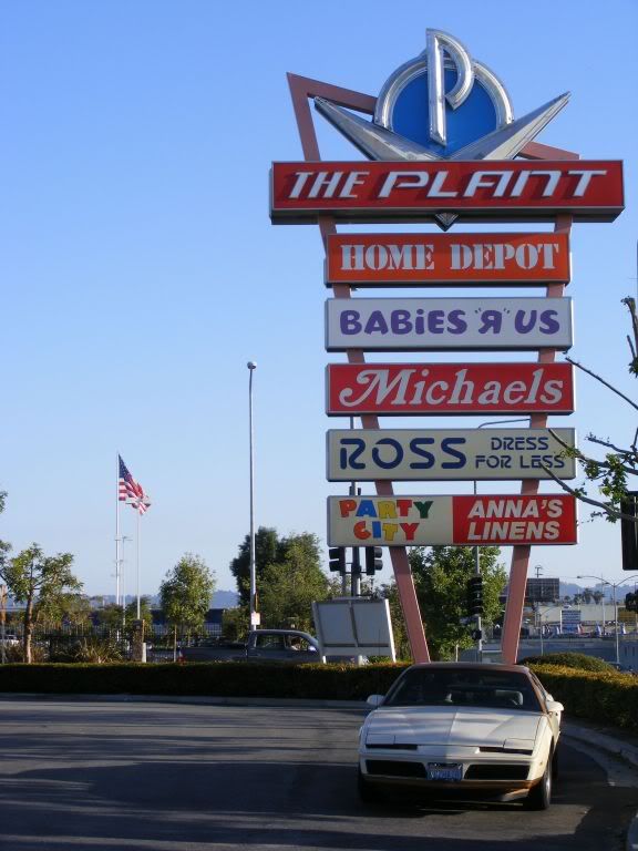
2003/1947
7876 Van Nuys Blvd, Van Nuys
This ginormous, sprawling car-oriented shopping center on the east side of Van Nuys Boulevard where one can catch a movie, buy some hardware or satisfy their "IN-N-OUT URGE" originally began its life as a large General Motors automotive plant (hence the name), pumping out Chevrolet trucks, other Chevy auto models, Buicks, Oldsmobiles and Pontiacs for nearly half a century, built mostly by residents who lived nearby, before closing down in 1992 to satisfy AQMD requirements. The plant was torn down six years later and Los Angeles City Councilman Marvin Braude resurrected the site into the ginormous shopping center in 2003. GM still operates a testing facility east of the stores. The Militant may or may not have written part of this blog post at the Starbucks (his cup may or may nor have read, "Milton").

1962
13651 Willard St, Panorama City
Another major employer that made Panorama City is Kaiser Permanente's Panorama City Medical Center. Though it opened in 1962, it was envisioned as far back as 1948 when industrialist Henry Kaiser developed his residential neighborhood (more on this later), and a large plot of land by Roscoe and Woodman was set aside for the construction of a hospital.

1948
15040 Roscoe Blvd, Van Nuys
In the post-war area, not only did the Panorama City community flourish with homes, shopping and industry, but what more appropriate way to take your shiny new Chevy made down the street to watch a drive-in movie? In the SFV, the Drive-In was king, but every king's reign comes to an end. The Van Nuys Drive-In was the last drive-in theater in The Valley, eventually sporting three screens (in 1983) with a capacity for nearly 900 cars. The drive-in closed for good in 1992 and was demolished in 1998. The property was purchased by the LAUSD, which built Vista Middle School on the site in the early 2000s.

1955
8401 Van Nuys Blvd, Panorama City
When it comes to shopping centers in the San Fernando Valley, North Hollywood's Valley Plaza might have been the pioneer, the Topanga Plaza might be the first enclosed mall (1964) and the Sherman Oaks Galleria might get credit for being ground zero of 1980s "Valley Girl" culture, but Panorama Mall deserves its own induction in the 818 Mall of Fame. It was part of Kaiser and Burns' plan for Pano to surround their hood with commerce and industry, as a place, unlike the regional shopping center behemoths of the time, where residents can simply

2009 (Built 1965)
8450 Van Nuys Blvd (corner Chase St - get it?), Panorama City
You would think that this location would be the product of some clever marketing. But corporations don't think that way. Rather, it was a matter of happenstance. Originally established as a Home Savings of America in 1965, it went under the guise of Washington Mutual in 1998 until WaMu was eaten up by J. P. Morgan Chase Bank a decade later. As fate would have it, this Chase Bank is on the corner of Van Nuys Boulevard and none other than Chase Street. You can't make this stuff up, folks. Now if there was ever a high-speed chase that ended up here, The Militant would explode.

2000
8610 Van Nuys Blvd, Panorama City
Plaza del Valle (Plaza of the Valley), originally built in the 1970s as a strip mall is an outdoor shopping court, nestled behind the nondescript storefronts on the east side of Van Nuys Blvd between Chase and Parthenia streets (and the perfect counterpoint to the mostly-indoor Panorama Mall down the block), was heavily influenced by Downtown's Olvera Street. The old strip mall was re-imagined and re-built in 2000 by its non-Latino developers to serve Pano's growing Latino community. The complex features retail shops and stalls, eateries, fountains and an entertainment stage.
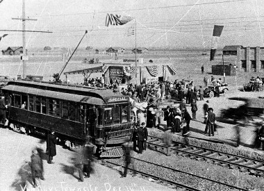
1913
Van Nuys Blvd at Parthenia St, Panorama City
Now that The Militant made his epic Pacific Electric Archaeology Map and detailed where every passenger Red Car line went in Southern California, you all should know by now that Van Nuys Boulevard used to be a PE right of way (and if you didn't, then THE MILITANT IS DISAPPOINTED IN YOU!) So you wouldn't be surprised at all that the westward sweeping curve on Parthenia Street is where the line, which reached this part of The Valley in 1913, diverges from Van Nuys Blvd and continues westward, then northward again to San Fernando. Due to the rising costs of maintaining and operating the line (and not because of some silly Roger Rabbit Judge Doom conspiracy), it was partially shut down in 1938 (years before the supposed conspiracy happened, BTW...but no matter how many facts get shown in your face, you still continue to believe it, right? RIGHT?) up to Sherman Way, and the entire SFV line was closed in 192 (y'allz should have that memorized by now...).

1948
Area bordered by Van Nuys Blvd, Osborne St, Woodman Ave & Roscoe Blvd, Panorama City
Whatup, homes? There's a bunch of them here east of Van Nuys Blvd here in Pano. When World War II was winding down in 1945, real estate developer Fritz B. Burns and industrialist Henry J. Kaiser purchased 400 acres of former dairy farms and alfalfa fiels for $1 million to build their own planned residential community consisting of affordable, pre-fab, single-story homes on winding streets to break up the SFV grid monotony. They built it, and they came.A General Motors factory set up shop down the street, space was reserved for a future hospital, and nearby breweries and aerospace companies also generated employment centers. A large shopping center was built, and Mr. Burns (no, not that one) brought his own personal reindeer to the Panorama Mall to delight shoppers each holiday season (and also found it an opportunity to market some houses to them). Of course, back then in the era of discriminatory housing covenants, you had to be white (and purely white, to be exact) to own these homes, a practice that was in place until the Civil Rights Act was passed in 1968. Today, the majority of residents who live in the former Kaiser Homes development are non-white and primarily of immigrant background -- predominantly Latino, as well as Filipino and Thai, providing the proverbial middle finger of justice extended to the legacy Burns and Kaiser.
.JPG)
1985 (Built c. 1950s)
9303 Roslyndale Avenue, Arleta
Months after Marty McFly traveled into the future, it couldn't be more appropo to take a short detour from the CicLAvia route southeast down Canterbury Ave, left on Kagel Canyon and right on Roslyndale to see the very house which portrayed the McFly family residence in the "Back to the Future" movie saga. NOTE: This is a private residence, please do not bother the current occupants, and please refrain from shouting, "HELLO, MC FLY?!" outside.
.JPG)
1985
Sandusky Ave at Kagel Canyon Street, Arleta
And if you haven't felt enough of The Power of Love yet, head back onto Kagel Canyon, turn right and stop at the intersection of Sandusky Avenue to see the very street where Marty McFly skateboarded down in the first "Back to the Future" film. It don't take money, don't take fame, don't need no credit card to ride this train (well, unless you're talking about a TAP card...).
2012
Van Nuys Blvd between Arleta Ave and Bradley St
Spurred by a local need to increase community pride and aesthetics, several local artists painted murals along the Van Nuys Blvd corridor in Pacoima and thus was born Pacoima Mural Mile. Famous native Ritchie Valens (more on him later) is a popular subject on these walls, as well as cultural icons from Frida Kahlo to La Virgen de Guadalupe to Danny Trejo. Think of this as an Epic CicLAvia tour within an Epic CicLAvia Tour! View the Pacoima Mural Mile map here: http://www.muralmile.org/#!/zoom/csgz/coq6

1947
13428 Remington St, Pacoima
This was the house that '50s rock star and Pacoima native Ritchie Valens purchased for his mother, Concepcion Reyes, in 1958 from the proceeds of his newfound "La Bamba" fame, and was also his final residence until The Day The Music Died on February 3, 1959. NOTE: This is a private residence, please do not bother the current occupants, and please refrain from shouting, "RITCHIEEEEEEEEEEEEE!" outside.

1994
10731 Laurel Canyon Blvd, Pacoima
The former Paxton Park, re-dedicated in 1994 to Pacoima's most famous native in order to spur community pride, Ritchie Valens Park isn't just a patch of grass with a famous person's name on the sign, it features a skate park, a baseball diamond, basketball courts, a swimming pool and a children's playground with historical and interpretive displays highlighting the life of the local Mexican American rocker, whose life was tragically cut short at the age of 17 on a Wisconsin plane crash. Weeeeeeeeeeeeell come on, let's go, let's go, go, everybody...to this nice little detour not too far away from the main CicLAvia route.

1876
Van Nuys Blvd at San Fernando Rd, Pacoima
This is the very first time a CicLAvia route will cross an active mainline railroad track, so please do not ignore the warning lights, bells and gates! These tracks were originally built in 1876 by the Southern Pacific Railroad to connect Los Angeles to Saugus, where continuing lines on to Ventura and the Antelope Valley were built. In the early 1990s, it was taken over by the Southern California Regional Rail Authority, otherwise known as Metrolink, for a commuter rail line from Union Station to Santa Clarita, which opened in October 1992. But on January 17, 1994, the earth shook violently and the 5/14 freeway interchange collapsed. To facilitate commuters coming in from the Antelope Valley during the post-Northridge Earthquake period, the line was extended to Lancaster (which wasn't planned to be built until 2004 at the earliest under normal circumstances) thanks to FEMA funds and was opened IN ONE WEEK. In the near (or distant) future, running parallel to the existing railroad tracks will be the proposed California High Speed Rail system from San Francisco to Los Angeles (...which may or may not get built).

1956
13156 Van Nuys Blvd, Pacoima
Established in San Fernando in 1944 to serve the growing Mexican American community in the area by Francisco and Pilar Tresierras while two of their sons served in World War II, and operating from this very location for 60 straight years, Tresierras Supermarket is a full-service
Latino supermarket featuring produce, dry goods, a carniceria and an in-house tortilleria. It's one of the long-time anchors of Pacoima's Latino community, serving local residents for generations. And we're quite sure that Ritchie Valens himself shopped here back in the day.

1942
10995 Lehigh Ave, Pacoima
This public housing project next to the northern terminus of the CicLAvia route features 448 apartments built in the World War II era by the Housing Authority of the City of Los Angeles. It was built to house workers from the Lockheed aircraft factory in Burbank (though it's pretty far from Burbank -- no freeway and no PE line back n the day) and was unique in that it was racially integrated, and comprised the largest African American community in the San Fernando Valley at the time.

c. 1940s
13058 Filmore St, Pacoima
Though Ritchie Valens' birthplace is unknown, this was the very house where he spent most of his childhood in (after living briefly with an uncle in Santa Monica as a kid). At the age of 9, he taught himself how to play guitar at this very house and took it to Pacoima Jr. High School where he performed for his classmates and joined a local band, The Silhouettes as their singer, until he was discovered by record label owner Bob Keane, and the rest was history.
Duuuuude. The 4.2-mile CicLAvia route is kinda short. Let's go a little farther, shall we? Continue on Van Nuys and make a right on Foothill...
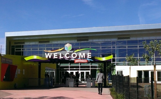
2014 (Built 2007)
11800 Foothill Blvd, Lake View Terrace
The de-facto successor to the nbow-defunct Childrens Museum of Los Angeles, which operated out of the Civic Center for most of its 20-year existence, this building was originally built in 2007 to house an expanded version of the museum. but after the nonprofit went bankrupt in 2009, this building sat as a white elephant on the corner of Foothill and Osborne for seven years, until the City entered a partnership with Santa Ana's Discovery Science Center and operated the intended Children's Museum site as "Discovery Cube Los Angeles" in 2014. But despite the museum's corner location, it's a horribly pedestrian-unfriendly experience just getting to the dang place, where one has to enter through the Hansen Dam Recreation Area's main entrance on Osborne Street, and drive some distance before entering the Discovery Cube parking lot. Whatup with that?

1991
Foothill Blvd, east of Osborne St, Lake View Terrace
Twenty-five years ago this week at this very spot (just behind the Discovery Cube building on Foothill) was where African American motorist Rodney King was beaten by four mostly-white LAPD officers after a brief freeway chase (they didn't televise those things back then). But they did televise the grainy VHS handicam video (no smartphones back then, kids) that was shot by local resident George Holliday, who lived in the apartments on the north side of Foothill. The beating, after airing on KTLA a few days later, sparked outrage in the city's African American community and called to attention the issue and history of police brutality. The acquittal of the four cops over a year later triggered the largest riots in Los Angeles' history.

1940
11770 Foothill Blvd, Lake View Terrace
Built in response to the Great Los Angeles Flood of 1938 that caused catastrophic flooding near the Los Angeles River in The Valley, the City tapped the U.S. Army Corps of Engineers to build a 2 mile-long, 97 foot-high flood control dam on the site of Homer and Marie Hansen's horse ranch (apparently you get naming rights in exchange for eminent domain). It's designed to contain and control runoff from the San Gabriel Mountains, entering the dam area from Bug Tujunga Canyon, where water ultimately enters the Los Angeles River via the Tujunga Wash (and millions of gallons of water just get wasted in the ocean...). But the area, which also sports a large park and recreation area, can also be a part of Los Angeles' water future as the area sits on a large aquifer. The LADWP has long-term plans to clean up the SFV aquifer in the future to allow more harvesting of local groundwater (which currently comprises 10-15 percent of our city's water source), and open the possibility of stored or recycled water.
Oh yeah, if you made it this far, DO NOT PASS UP THE OPPORTUNITY to ride your bike on the dam itself (there's a dedicated bike path)!
Happy CicLAvia and STAY MILITANT!