
 |
| Happy 25th Birthday, you Millennial, you! |
You may or may be familiar with The Militant's Angeleno's award-winning Epic CicLAvia Tour posts, highlighting various points of interest along the various open streets routes, but did you know The Militant has done the same for the Los Angeles-to-Pasadena Metro Gold Line and the Metro Expo Line?
This time around, to celebrate a quarter century of Metro Rail, The Militant offers his Epic 25th Anniversary Metro Blue Line Tour, which points out historic, surprising, and off-the-beaten-path locations on or very near our first light rail route. Even if you've been a regular Blue Line commuter for the past 25 years, if you think you know the Blue Line, guess again!

1993
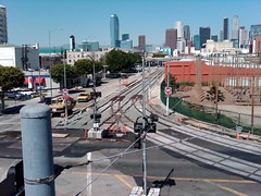
7th St./Metro Center Station, Downtown Los Angeles
Riders waiting at the outbound platform at the 7th Street/Metro Center station may or may not have noticed a peculiar digital countdown clock situated on a pole in the middle of the tracks. It seems to count down regardless of whether there’s a train or not. What is it for?
In 1993, to speed up Blue Line travel times, the street signals along Flower Street and Washington Blvd. were synchronized to give priority to light rail trains along those streets. This timer clock allows train operators to time their exact departures in accord with the street signal synchronization, so that when the white light under the clock is lit and the train begins to depart under normal operating speed, the train will encounter a continuous series of green lights.

1990
Pico and Flower Streets, Downtown Los Angeles
Pico Station is where it all began; it was the first operational station in the history of Metro Rail. The station was the site of a public dedication ceremony kicking off the opening of the line (See The Militant's exclusive archived video of the event here). The Blue Line on opening day in 1990 was somewhat shorter than the line we ride today. For the first two months of operation, the Blue Line only ran from Pico Station to the Anaheim St. Station.
Back then, it was just located in a far-flung region of Downtown. It wasn’t until the late 1990s when the Staples Center was built that the South Park section of Downtown started to become revitalized. Today, the recent upgrades of the Blue Line stations have also given the station a minor facelift.
The station also has the shortest name of any Metro Rail station in the entire system (Well, okay, it's tied for 1st place along with Soto and Lake).
2010
Flower Street and Washington Blvd, Downtown Los Angeles
The first surface-level "junction" track that switches trains among the Blue and Expo lines is located here. A few months after the Expo Line opened, the California Public Utilities Commission ordered Metro to replace a section of rail within the switch track that would potentially cause derailments.
The other junction track on the Metro Rail system is the one north of the Wilshire/Vermont subway station. Future junction tracks will be built west of the Metro Green Line Aviation Station (serving the Green and Crenshaw lines) and another switch track as part of the Regional Connector under Little Tokyo.
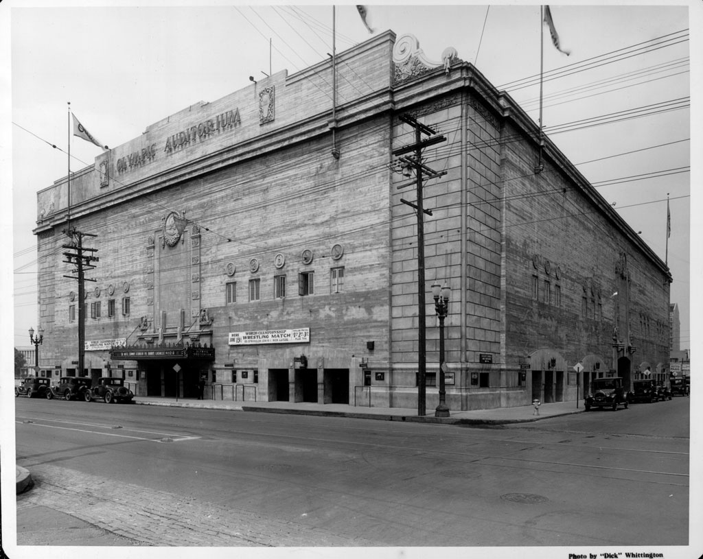 4. Olympic Auditorium
1924The other junction track on the Metro Rail system is the one north of the Wilshire/Vermont subway station. Future junction tracks will be built west of the Metro Green Line Aviation Station (serving the Green and Crenshaw lines) and another switch track as part of the Regional Connector under Little Tokyo.
1801 S. Grand Ave., Downtown Los Angeles
This historic venue through the years, easily seen from the nearby Blue Line Grand station, has hosted boxing matches (including the boxing competitions for the 1932 Olympic Games), wrestling bouts, roller derby events and concerts. The match sequences from the original Rocky movie was filmed here, as well as Bon Jovi's "Livin' On A Prayer" and Janet Jackson's "Control" music videos.
For the past decade the venue has been owned by a Korean Christian Church known as Glory Church of Jesus Christ (hence the large Jesus mural on its south wall).

1893
Washington Blvd and Hill Street, Downtown Los Angeles
The first permanent baseball field in Los Angeles isn't Dodger Stadium, nor was it South Los Angeles' Wrigley Field nor the Fairfax District's Gilmore Field. It was here at Washington Park, located near Washington and Hill, where the Pacific Coast League Los Angeles Angels of Los Angeles played from 1893 to 1925 (the first Washington Park stood from 1893 to 1912; the second was in use from 1912 to 1925. It was torn down in the 1950s. William Wrigley, the team's owner, left Washington Park after he was denied permission to build an underground parking garage. He then moved his Angels to his own Wrigley Field in 1925. Washington Park it was also one of the home venues of the USC Trojans football team before the Coliseum. Adjacent to Washington Park was an amusement park named Chutes Park that stood on the land where the municipal courthouse now stands.

1957
1900 S. Central Ave, South Los Angeles
What is currently a taco stand at the southeast corner of Central and Washington was once the first McDonalds in the city of Los Angeles (and the 11th McDs in the entire chain) which opened in 1957. As you may or may not know, McDonalds originated in San Bernardino in 1940 by the McDonald brothers, and was later taken over by Illinois businessman Ray Kroc, who turned the unique Southern California hamburger chain into the gargantuan unhealthy corporate chain we know today. The trademark side arches were present on this building (and a single arch present on the corner sign) up until the early 2000s. But hey, tacos are more healthy for you than McDonalds junk, so eat up.

c. 1941
1600 E. Washington Blvd, South Los Angeles
On your southbound Blue Line ride, look to the right just before the train curves towards the Washington Station and look for the "Hanson Tank" sign. To the left of the sign, and right above the main doorway is a tiny cubby-hole featuring a Buddha statue. Years ago, a Militant Elder told The Militant Angeleno that the buddhas were placed there to give Japanese Buddhists a clandestine place to worship after December 7, 1941. The Militant covered this location in an early MA blog post in October 2007.

1989
Washington Blvd and Long Beach Avenue, South Los Angeles
Due across the street and due north of the Blue Line's Washington Station, there's a stretch of track that diverges from the Blue Line route that seems to head off into oblivion. The track is one of several along the Blue Line route that function as an emergency storage track for broken trains or so-called "gap" trains to replace trains that have been taken out of service due to technical issues.
The tracks follow the original Pacific Electric 4-track "speedway" alignment that led to the Pacific Electric Building at 6th and Main streets in Downtown Los Angeles. In fact if you follow the Washington Tail Track north to 16th Street, you can still see the old Pacific Electric tracks partially buried under the pavement!
The Washington Tail Track is rarely used nowadays, though in March the track was used to temporarily store the new Kinkisharyo light rail vehicle which was being tested on the Blue and Expo lines at the time.

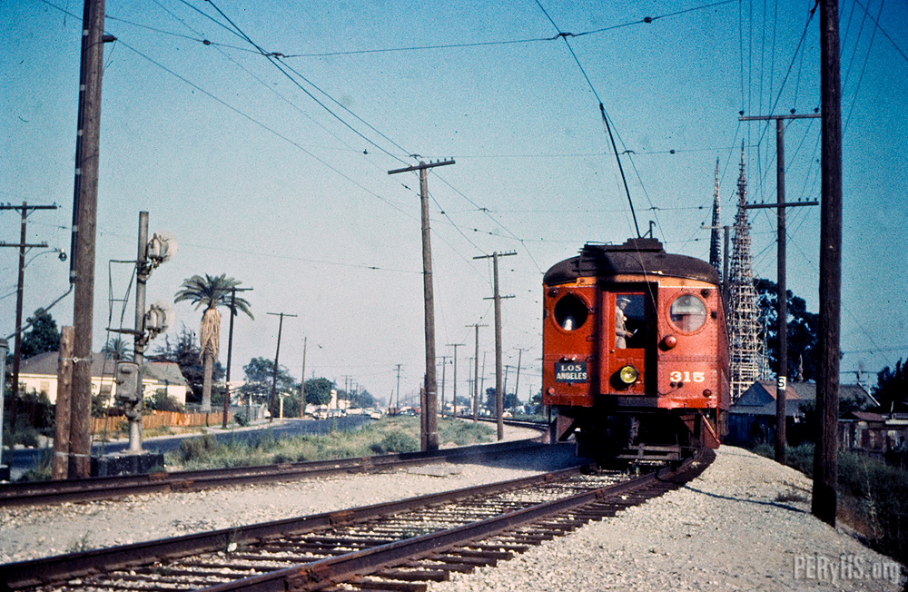
1904 (discontinued early 1980s)
Long Beach Ave., south of 25th Street, South Los Angeles
About 6 blocks south of the Washington Station, look to your right and you'll see tracks in the street mysteriously end at the fence that protects the Blue Line tracks. Look westward and you'll see an abandoned rail right-of-way. That was, until 1958, the Pacific Electric Air Line trackage which went all the way to Santa Monica (and until the early 1980s as Southern Pacific freight track), and functions today west of Figueroa Street as the Metro Expo Line. During the Pacific Electric era, the Downtown-bound trains from Santa Monica headed all the way to Amoco Junction (named after the American Olive Company factory nearby) to join the 4-track "Speedway" trunk line and head north.

1994 (demolished 2006)
41st St between Long Beach Ave and Alameda St, South Los Angeles
This large, empty plot of land just east of the Blue Line tracks, a half-mile north of the Vernon Station was home to the 14-acre South Central Farm run by community members between 1994 and 2006. Acquired by the City of Los Angeles in 1986 via eminent domain from private landowners, it was originally slated for use as an incinerator site, a plan dropped due to community opposition. The City allowed the neighboring nonprofit Los Angeles Regional Foodbank to run the site as a community garden. Over 300 low-income families from nearby communities turned the land into one of the largest urban farming projects in America over 12 years. But in 2001, the land's former owner sued the City for breach of contract, because the incinerator plant was never built. Eventually the City settled with the landowner in 2003 and they began the process of re-claiming the plot, eventually evicting the farm in 2006. To this day, the land lies vacant.
The controversy attracted the support of various celebrities, public officials and philanthropic organizations, including a failed attempt by The Annenberg Foundation to purchase the land, but it did galvanize the community and led to the rise in urban farming activism, especially in the South Los Angeles area.

2000
5790 Compton Ave, South Los Angeles
A few blocks west of the Blue Line's Slauson Station lies one of the best-kept secrets in South Los Angeles -- Augustus F. Hawkins Natural Park, an 8.5-acre surreal green oasis in the 'hood, featuring ponds, native plants, hiking trails, picnic areas and even wildlife. This former DWP pipe yard was converted into a re-created natural park, named after the late African American congressman who represented the area for 28 years, in 2000 by the Santa Monica Mountains Conservancy, which trucked in actual dirt from Malibu mudslides to the site to form the park's terrain. The park is popular with local residents seeking refuge from urban life, and the park is also popular with members of the local Audubon Society, who frequent the park to do bird sightings and bird counts.

1904
Slauson Ave and Randolph St, South Los Angeles
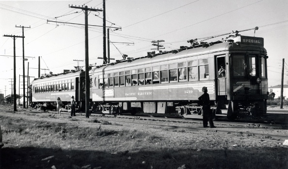
When passengers rode the Blue Line for the first time in July 1990, they were thrilled to have the train suddenly shoot up the elevated structure, with a towering view of the area below as the train stopped at the Slauson Station. While stopped here, you can see a piece of the Blue Line's Pacific Electric heritage by just looking to the east: The unmistakable curved "wye" tracks heading eastward formed another major junction to the PE's Long Beach Line trunk, as the place where trains bound for Fullerton, La Habra and Whittier diverged from the quadruple-tracked "Speedway."
Francis Nixon, the father of President Richard Nixon, was once a Pacific Electric motorman who navigated his Whittier-bound trains through this very junction.

8908 S. Maie Avenue, South Los Angeles
There are many parks that line the Blue Line route, but this one is unique for two reasons. As you head southbound and depart the Firestone Station, look immediately to your right and you'll see a park and recreation center. It's a Los Angeles County-run park called Colonel Leon H. Washington Park, named after the founder of the Los Angeles Sentinel newspaper (originally called The Eastside Shopper), the city's premier publication in the black community. The other reason is that the rec center here is a popular spot for NBA stars such as Kobe Bryant, Lebron James, Kevin Durant and others to play pick-up games and compete in the Nike-sponsored Drew League, a weekend summertime program where the biggest stars in basketball play with and against locals from the community.
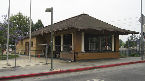
1904
1686 E. 103rd Street, Watts
Adjacent to the Blue Line's 103rd St/Watts Towers station is a mustard-colored building that was once the Pacific Electric's Watts depot. A popular stop along the old PE Long Beach Line, the building survived not only the PE's abandonment, but was the only wooden structure that was not set on fire during the 1965 Watts Riots. After a renovation project in the 1980s, the Watts Station has functioned since 1989 as a Los Angeles Department of Water and Power customer service center.
1903
Graham Ave and 105th Street, Watts
In the Pacific Electric era, this junction, where the overhead pedestrian bridge is located today, marked the end of the four-track "Speedway" which had express trains from 9th and Hooper streets in Downtown Los Angeles go to/from Watts in the center tracks, while the outer tracks handled local stops Dominguez Junction is where trains along the Long Beach trunk line headed west to Torrance, southwest to San Pedro and southeast to Santa Ana via Bellflower.
Directly adjacent to the former Santa Ana tracks are the famed Watts Towers, built by Italian immigrant Simon Rodia (who actually called his sculpture "Nuestro Pueblo") between 1921 and 1954. There is definitely a direct relationship to the Pacific Electric: Rodia used the rails on the PE Santa Ana tracks as a fulcrum to bend his steel bars into shape, enabling him to build his masterpiece.

1990
Willowbrook Ave at the 105 Freeway, Willowbrook
At the nexus of the Blue and Green Lines, just east of the Willowbrook Station is Metro's Rail Operations Center (ROC), where all of the 87-mile rail system's signaling, dispatching and security systems are manned and monitored. The building also houses a Los Angeles County Sheriff's Department station, as part of their Metro system security operations.
Adjacent to the ROC is a non-revenue connector track that allows light rail vehicles to transfer between the Blue and Green lines for emergency or service purposes. The single track also allows light rail vehicles based out of the Metro Green Line yard in Torrance to move to the Long Beach yard, which houses a paint shop and heavier maintenance facilities. But in case you're wondering, the track is not equipped to handle revenue service from, say Long Beach to Redondo Beach.
The Willowbrook Station is due for a major renovation in the near future.

2013
275 N. Willowbrook Ave, Compton
If you're a regular Blue Line commuter and need your fill of fresh, locally-grown produce, get off at the Compton Station on Thursdays from 3 to 7 p.m. and visit the weekly certified Blue Line Farmers' Market. Started in September 2013 to combat food desert concerns in the local community, the market has become a hit with locals and commuters alike.
There are currently 24 weekly certified farmers' markets at or near Metro Rail stations, visit them regularly!
The first waterway the Blue Line crosses isn't the Los Angeles River, but one of its tributaries, Compton Creek. You can see the 8-mile stream before approaching the Artesia Station and immediately east of the Del Amo Station. Be on the look out for horses, as there's an equestrian trail alongside it. The equestrian and cowboy culture of Compton actually predates its street gang reputation by several decades, and in fact lives on today in the form of a youth equestrian program called the Compton Jr. Posse.
Also located along Compton Creek, midway between the Artesia and Del Amo Stations east of the Blue Line tracks is the Rancho Dominguez Adobe Museum, highlighting the Spanish-era land grant roots and early California history of the Compton and Carson areas. Worth a bike ride from either of those stations!

2002
Along South Alameda Street
Midway between the Artesia and Del Amo Stations is what appears to be a highway, which is actually Alameda Street. adjacent to it are a set of railroad tracks -- both the street and the tracks form the Alameda Corridor, a ground transportation system opened in 2002 that allows trucks and trains to easily access the Ports of Los Angeles and Long Beach -- important gateways for importing and exporting for not just Southern California, but the entire United States. Toys from China and cellphones from Korea pass through the Alameda Corridor in the form of intermodal shipping containers en route to Chicago or other U.S. destinations. The corridor began construction in 1997 as a way to consolidate the Union Pacific and BNSF railroads onto a unified, high-capacity, mostly grade-separated track to and from the port area. North of here, the tracks run in a trench alongside Alameda Street to railroad yards southeast of Downtown Los Angeles.

1989
4350 E. 208th St., Long Beach
Sandwiched between the 710 Freeway and the Los Angeles River is the Metro Blue Line Yard and Shops, otherwise known as Metro Division 11. It is here where Blue and Expo Line cars make their home and are cleaned, painted and serviced. Cars from other light rail lines also visit this yard for work that can't be performed at their respective home yards. Blue Line trains also stop near the yard regularly on a mini-platform to allow operator crew shift changes.
21. Pacific Electric Abutments
1901
East Bank of Los Angeles River, North Long Beach
As soon as your Long Beach-bound Blue Line train crosses the Los Angeles river, look to the right side of your train and you'll see about four concrete abutments next to the tracks. Those were part of the Pacific Electric Long Beach Line infrastructure -- the abutments supported the old Long Beach Line bridge that crossed the Los Angeles River.
1904
Long Beach Blvd, north of Willow Street
Look to the left after your train leaves the Willow Station and you'll easily see the now-paved-over right-of-way that diverged from here that formed Pacific Electric's Newport-Balboa Line, which reached the PE's southernmost point in Balboa Island. The line today supports parks and bikeways, as well as this bridge in Long Beach that still exists today, which The Militant covered in 2011.
1990
Long Beach Blvd, 1st Street, Pacific Avenue and 8th Street, Downtown Long Beach
The first "extension" of the Metro Blue Line opened in September 1990 when the Long Beach Loop was completed, allowing Blue Line trains to run in a clockwise-loop around Downtown Long Beach before heading north to Los Angeles (Before September 1990, Long Beach Transit shuttle buses painted like Blue Line trains provided interim service on the Long Beach Loop). Early operation scenarios for the Blue Line planned for "Loop Only" trains (the original rolling head signs of Blue Line trains had such a designation) that ran continuously through the Long Beach Loop, but in reality they never had a need to happen.

1996
223 E. 1st St, Downtown Long Beach
In 1996 the nation's first-ever Bikestation opened here in Downtown Long Beach, just yards away from what was then called the Transit Mall Station (now the Downtown Long Beach Station). It was a one-stop facility for bicycle commuters and recreational cyclists alike, as a place to park, maintain, rent or purchase bike accessories. In 2011, the operation moved into its current, very orange, expanded facility. The Bikestation was a pillar of Long Beach's bike community and bicycling infrastructure, which includes protected cycle track bike lanes, bike paths and several marked bike lanes across town.
25. Pacific Ave. Tail Track
1990
Pacific Avenue and 8th Street, Downtown Long Beach
Here is the southern-end counterpart to the aforementioned Washington Tail Track. This track was also designed to temporarily store bad-order or malfunctioning trains, as well as supplemental trains to fill in service gaps made from out-of-commission trains. It is also rarely used.