Monday, September 4, 2023

Moving Right Along...


 All good things may or may not come to an end. After 16 years, the Militant is making his last post on This Here Blog Site...Because he has recently purchased his own domain and has set up a brand-spankin' new WordPress blog site! So, no, The Militant isn't calling it quits, he's just moving. He's had it with this Blogger.com platform and its very user-unfriendly formatting. But history-loving archivist he is, he will keep this site up as The Militant Archives and continue to link to this one when and where appropriate. Some important posts will be updated and migrated to the new site as time permits though.

In the meantime, you can find The Militant at his new website: militantangeleno.com! See you or see you there!

Saturday, June 17, 2023

The Militant's Epic CicLAvia Tour XLVI!!!


Interactive map! Click here for larger view.

The 46th CicLAvia is upon us this Sunday, the fourth of eight such open streets events in 2023, and this is the first, and perhaps only all-new route in this year's lot that doesn't include a portion or alteration of a previous CicLAvia route. At 6.2 miles, its one of the longest CicLAvias this year (especially since last month's CicLAmini edition in Watts was so dang short...). This time, we head deep down Vermont from the 30s to the 90s-numbered streets. It was a corridor which was quite a happening place back in the 1930s-1940s, and some of the vestiges of that era remain in buildings with Art Deco and Streamline Moderne architecture, and some very unique business signage (Forgive the lateness of this Epic CicLAvia Tour Guide post - Life and The Metro Regional Connector opening got in the way...It's going on 6 a.m. Saturday morning as he's typing this and The Militant is looking forward to at least a couple hours' sleep...Zzzzz...).

Welp, see you or not see you on the streets this Sunday!

Oh yeah, if you found this Epic CicLAvia Tour guide useful and visit any of these sites, please add the #EpicCicLAviaTour hashtag to any social media post that includes it. The Militant will be glad to re-tweet!

And if you appreciate The Militant's work, kick him a little love via PayPal! He *hates* asking for money, but you know how it is these days...A Militant's gotta pay his bills! He sacrifices a lot of his time to do this! Your support is much appreciated!

Support The Militant Angeleno!
https://www.paypal.com/donate/?hosted_button_id=K5XC5AM9G33K8


1. Lucas Museum of Narrative Art
2025
Vermont Avenue and 39th Street, Exposition Park

Taking shape on west side of Exposition Park like a Naboo Royal Starship is the George Lucas Museum of Narrative Art (or, "The Luke," as The Militant would like to call it), a state-of-the-art visual, cinematic and interactive museum founded by 'Star Wars' creator and filmmaker George Lucas and his wife Mellody Hobson. The site, located in close proximity to Lucas' alma mater, USC, beat out other site proposals in San Francisco (home of Lucasfilm, Ltd) and Chicago (Lucas' birthplace) when it was announced in 2017. Originally intended to open in 2021, it was delayed to 2025 due to the COVID-19 pandemic and various construction delays.


2. Los Angeles Memorial Coliseum
1923
3911 S. Figueroa Street, Exposition Park

You all know this sports venue. Chances are you've been to a sporting event, concert or other gathering here at last once in your life. Opened on May 1, 1923 - 100 years ago - in honor of the local soldiers who died in World War I (hence the "Memorial" in the name), it is THE home of Los Angeles sports. It was designed by Los Angeles icon architects, the father-and-son team of John and Donald Parkinson. At one time or another, it has been the home turf of the Rams, Raiders, Chargers, Dodgers, UCLA Bruins and USC Trojans (who still play there today). Its iconic peristyle torch tower lets you know that it has hosted two Olympic Games (1932 and 1984, with a third in 2028), one World Series (1959) and two Super Bowls - including the first-ever (1967, and later 1973). And there's been so many more. Happy 100th to the Coliseum!

3. Manual Arts High School
1910
4131 S. Vermont Avenue, Exposition Park

Built in 1910, it is the oldest high school in the Los Angeles Unified School District still standing on its original site (Los Angeles HS moved from Downtown to Mid-City in 1917 and Polytechnic HS moved from Downtown to Sun Valley in 1957). It suffered serious damage in the 6.4 1933 Long Beach Earthquake, and its buildings were rebuilt through the mid-1930s, this time in its current WPA Streamline Moderne style, designed by none other than John and Donald Parkinson. Notable alumni include film director Frank Capra, Jackie Robinson's widow Rachel Robinson and former Los Angeles County Supervisor Yvonne Brathwaite Burke. From 1911-1915, a teacher by the name of Ethel Percy Andrus taught at Manual Arts. In 1916, she moved on to Lincoln High School where she became the first woman in California to become a high school principal. After her retirement, she founded the American Association of Retired Persons (AARP), which also happens to be a major sponsor of CicLAvia. Full circle!

4. Vermont Square Branch Library
1913
1201 W. 48th Street, Vermont Square

Built at a cost of $35,000 from steel magnate and philanthropist Andrew Carnegie's library fund, Vermont Square was the oldest and first of the Los Angeles Public Library system's 72 branches to be built, and the first library to be owned by the LAPL (the Central Library opened 13 years later and its predecessor was in a leased building). The single-story Italian Renaissance Revival building was designed by architects Hunt & Burns, who also designed the Wilshire Ebell Theatre and the Automobile Club of Southern California headquarters on Figueroa. It was the first of six (and three surviving) such LAPL branches built from the $210,000 Carnegie Libraries grant in the 1910s (the other surviving branches are the Lincoln Heights Branch, and the Cahuenga Branch in East Hollywood). The Militant visited the Vermont Square Branch Library back in 2011.

5. Santa Fe Railway Harbor Subdivision/Metro Rail To Rail Project
1880s/2024
Paralleling Slauson Avenue, South Los Angeles.

The CicLAvia route crosses a set of railroad tracks in the street...but there are no more tracks to the east or west of Vermont Avenue. Whatup with that?! Well, this abandoned railroad right-of-way was an important part of the Atchison, Topeka and Santa Fe Railway (a.k.a. the Santa Fe) and Los Angeles transportation. It was built in the 1880s as the railroad's access to local sea ports (initially Redondo Beach in 1888, and later extended through Torrance to Los Angeles Harbor in the 1920s). It provided freight transport access for local industries - particularly the oil industry in El Segundo, as well as passenger/local commuter rail service up until the early 20th century. The line was abandoned in 2002 with the opening of the Alameda Corridor, providing a shared, direct access to the Harbor for all of the freight railroads. It is now owned by Metro, where a bicycle/pedestrian path currently known as the "Metro Rail to Rail Project" is under construction. The path will start from the K Line Fairview Heights station and head east along the former freight line to the Metro A Line Slauson station. A later phase will continue even father east to the Los Angeles River.


6. The Gage Avenue Bends
1930
Gage Avenue, South Los Angeles

Take a look at 11-mile Gage Avenue on a map and you'll readily notice that the street, which stretches from Bell Gardens in the east to Los Angeles' Hyde Park neighborhood in the west, is not as quite as straight as the other major thoroughfares in the absolute N-S-E-W Jeffersonian Grid dominant in Los Angeles (outside of the angled Spanish Grid of Downtown, of course). Why is this so? Was it a rail line? Not for most of the alignment (there were short sections that bore Los Angeles Railway and freight railroad tracks). The answer lies in how Gage Avenue was created: Named after California governor Henry T. Gage (1852-1924), who served from 1899-1903, the far eastern end of the avenue (where the Gage family hacienda was located) was named "Gage Road" in 1925, presumably in memory of the recently-deceased former governor. In 1930, Gage Avenue was designated, which involved the piecemeal merging of the former 63rd Street, Hyde Park Boulevard, and Baker, Merrill and Irvington avenues. Curved sections of road were carved out of city blocks to create a continuous alignment, and Gage Avenue was born.


7. Congress Theatre
1939
7506 S. Vermont Avenue, Vermont Knolls

Back in the day, this part of town - then known as "Southwest L.A." (hence Los Angeles Southwest College just a few miles away), was a pretty happening place, with numerous shopping destinations and neighborhood theatres. One of them was the Art Deco Congress Theatre, designed by Clarence J. Smale. The architect  designed other theatres in Southern California, such as the Hawaii Theater in Hollywood, the Colorado Theatre in Pasadena and the Loyola Theater in Westchester, as well as a number of private homes, such as that of actor Buster Keaton. The 869-seat cinema opened on May 25, 1939 and featured 'Flirting With Fate' and 'Gunga Din' with a few celebrities of the day in attendance. In the 1940s, the theatre was bought by Harry Vinnicof, whose Vinnicof Theatres chain ran a number of other movie houses along Vermont Avenue, such as the Madrid, the Regent, the Temple and the Vermont (no, not the one that exists today - that was called the Campus Theatre). The Congress was popular for screening sci-fi and horror/monster movies. It the last reel rolled in Fall 1960 and a number of churches have used the building ever since.


8. Faith Dome/Site of Original Pepperdine University Campus

1937/1989
7901 Vermont Avenue, Vermont Knolls

This was the original campus of Pepperdine University (a faith-based liberal arts college founded by auto parts magnate George Pepperdine), which opened in September 1937. The 1930s Streamline Moderne structures of the original campus, designed by John M. Cooper (Santa Monica's NuWilshire Theatre, DTLA's Roxie Theatre) are still standing towards the southern and eastern ends of the property.
Pepperdine moved to its current Malibu campus after growing racial tensions between its predominantly White student body and staff and the predominantly Black residents of the surrounding neighborhood tragically culminated in the shooting death of a local teen by a university security guard in 1968. In 1981 the old Pepperdine campus property was purchased by a church called the Crenshaw Christian Center, which built the 10,146-seat Faith Dome (they put the "God" in "geodesic," you could say...) as their primary place of worship in 1989.


9. Hattem's Shopping Center
1931
8039 S. Vermont Avenue, Vermont Knolls

This towering Art Deco delight seems to be out of place on South Vermont. But back in the day, it was just another Art Deco/Streamline Moderne structure on the avenue. Isadore M. Hattem, a Turkish-born Shephardic Jew, was one of the pioneering merchants of the early 20th century, having started out as a produce vendor at Grand Central Market. In 1927, he created the first supermarket in Los Angeles, Hattem's Market, located in a Spanish revival building designed by architect Walter R. Hagedohm (who also designed Newport Beach's Balboa Inn) on Western and 43rd Street. In 1931, Hattem  opened a larger 2nd location here on Vermont, called Hattem's Shopping Center, also designed by Hagedohm. It was a 24-hour supermarket that boasted its own parking court and adjoining buildings with other retail spaces. In the 1940s, the market became Allen & Huck Markets, which closed in the early 1960s. It was later purchased by Pepperdine University and functioned as its administration building until they moved out to Malibu in 1969. The building, largely intact and renovated, is now a community center for the Church of Scientology.


10. Vermont Knolls
1928
Area bounded by 79th Street, New Hampshire Avenue, 83rd Street and Normandie Avenue, Vermont Knolls

You might have heard of various knolls - Bixby, Canterbury, Beyoncé...Well this collection of Spanish Colonial Revival and French Revival single-family homes, originally known as Vermont Avenue Knolls was created in the late 1920s in an area then-known as Southwest Los Angeles, marketed a middle-class neighborhood with affordably-priced homes accessible to Downtown by the Los Angeles Railway's F Line on Vermont, but also bearing driveways and detached garages. If you look at a map, you'll see an elliptical pattern formed by 81st Street and 81st Place. Where have we seen those patterns before? Why yes, in Leimert Park. In fact, Vermont Avenue Knolls was developed by The Walter H. Leimert company, at around the same time his larger Leimert Park development was built. The homes are recognized by the City of Los Angeles as the Vermont Knolls Historic District.


11. Balboa Theatre

1926
8713 S. Vermont Avenue, South Los Angeles

South Vermont had no shortage of cinemas. This one such Spanish Churrigueresque movie house, the Balboa Theatre, which seated 1,250, was designed by Lewis A. Smith, who also designed the almost-century-old Vista Theatre in East Hollywood/Los Feliz. Opened on April 6, 1926 as part of the West Coast Theatres chain, it was later part of the Fox Theatres chain and known as the Fox Balboa in the '30s, and later under the ownership of Southside Theatres. Its movie days came to a fin in the 1960s. In the 1980s, the Balboa was revived as a live music venue, specializing in punk and metal concerts (The Dead Kennedys performed here in 1985). In the '90s and '00s, it became a Nation of Islam mosque and is currently known as Pan-Andreas West, a movie production/filming facility.


12. Million Article Thompson Sign

1932
8938 S. Vermont Avenue, South Los Angeles

What is a Million Article Thompson? Who is Million Article Thompson? Was he a prolific journalist who wrote a million articles for some long-gone newspaper (gotta be the evening edition of that paper, perhaps)? Actually, Million Article Thompson was the name of a local hardware store in the below retail space. The store opened in 1932 and they bore a decidedly large neon sign on its roof to tell the whole world who they were. The store closed sometime later, but the sign remained (though its neon tubes long gone due to weather and decay), and is a curious vestige of the aesthetics of the Great Depression/Art Deco/Streamline Moderne/WPA era.


13. Happy Bear Sign
c. 1930s/1940s
9640 S. Vermont Avenue, South Los Angeles

The business currently known as Perfect Paint & Body features a rusted metal silhouette of what looks like a twerking teddy bear holding up some sort of rectangular sign. From the 1920s to 1950s, auto shops across the US had these signs, known as "Happy Bear" or "Laughing Bear" signs. Bear Manufacturing Company of Rock Island, IL was known for producing automobile wheel alignment  and diagnostic tools. Auto mechanic shops bearing (no pun intended, but maybe it was) the Happy Bear signs let customers know that the mechanics at the shop were trained by Bear and they were using their tools. Many servicemen returning from World War II in the late 1940s went to train at Bear's mechanic school in Illinois to learn new trades and start their own mechanic shops. Only about three dozen "Happy Bear" signs are still in existence nationwide, most of which are here in Southern California.

14. Kindle's Donuts/The Original Big Do-Nut
1950
10003 S. Normandie Avenue, Westmont

You might look at this ginormous donut sitting atop a single-story stand and scoff at it being a Bought-on-Wish.com version of Randy's Donuts. But hole on, your mind is in a twist here. You're actually looking at The O.G. Ginormous Donut Stand. Donut entrepreneur Russell C. Wendell opened the first of his Big Do-Nut stands right here in 1950. It was designed by Harry J. Goodwin and featured a ginormous 32-foot gunnite donut atop the retail stand. He opened nine other locations across Southern California, from Bellflower to Reseda. Big Do-Nut lasted for some 25 years, after which the individual locations went independent. The Inglewood Big Do-Nut, in operation since 1953, was bought by Robert Eskow in 1976 and re-named it after his son, Randy. The rest is history. Russell C. Wendell later moved on from donuts to tacos and hot dogs and started a chain called Pup-N-Taco (You might have heard of it). This location was bought by Gary Kindle in 1977. Of the five surviving Big Do-Nut locations, this is the only one to spell "Donut"/"Donuts" as "Do-Nut" from the original name. Definitely try the Texas Glazed here. It's almost as ginormous as the donut on top of the building!


15. Jesse Owens Park

1950
9651 S. Western Avenue, Westmont

The Militant remembers passing by this place during his Lil'Mil days before the 105 Freeway existed, when his family would make that 7-mile surface street trek along Century Boulevard from the 110 to get to LAX. This 20-acre Los Angeles County Regional Park seems to have it all: A gymnasium, a swimming pool (including heated indoor pools), basketball and tennis courts, a Dodgers Field of Dreams baseball diamond, a children's playground, a soccer field and a 9-hole, 3-par golf course. Originally built in the 1950s as Southwest Sportman's Park, it was re-named in 1980 following the death of Olympian Jesse Owens, the Track and Field athlete who won 4 Gold Medals (the first American to do so in that sport) at the 1936 Summer Olympics in Berlin, Germany. As both an American and a Black man, his record-setting performance at the time was a symbolic "up yours" to Adolf Hitler, who was present at the games and attempted to use the Berlin Olympics as a propaganda vehicle for Nazi Germany and the supposed superiority of the Aryan race (Well that didn't quite work out, did it?).

Happy CicLAvia!

BONUS: THE OFFICIAL MILITANT ANGELENO EPIC CICLAVIA TOUR FOOD GUIDE!

1. Mr. Fries Man
3844 S Figueroa Street, Exposition Park

Started in 2016 as a Gardena-based food truck whose loaded fries gained viral popularity via the Instagram platform. The Militant has been to its K-Line accessible Inglewood location. This one is right on the other side of the Coliseum, check it out!

2. Barbeque King
5309 Vermont Avenue, South Los Angeles

The place to go for tri-tip, ribs and links. Burgers also made here as well.

3. Slauson Barbacoa Corridor
All along Slauson Avenue, South Los Angeles

Perhaps one of the biggest hidden food secrets in Los Angeles. For the past few years now on weekends, a number of authentic Mexican barbacoa stands have set up along the abandoned BNSF railroad right of way along Slauson Avenue. Despite the Rail to Rail Project construction, many of them are still around, albeit moved to the other side of the street. The Militant can't recommend any single stand, try any of 'em, or judge them on the size of the lines/crowds. You can't miss here really.

4. Carnitas El Valy
Southeast corner of Vermont and Gage avenues, South Los Angeles

They're only here during the weekends, which is perfect timing for CicLAvia. This stand sells carnitas plates, as well as tacos.

5. Casa Honduras
9131 S. Vermont Avenue, South Los Angeles

In the mood for some Central American cuisine? This is the place for some authentic Honduran dishes.


6. Gorditas Salcido
9715 S. Vermont Avenue, South Los Angeles

Also only open on weekends, this stand sells authentic Mexican gorditas.

7. Kindle's Donuts
10003 S. Normandie Avenue, Westmont

The original Big Do-Nut stand! Try the ginormous Texas Glazed!

8. Dulan's on Century
1714 W Century Blvd, Westmont

Down for some Soul Food? This local institution's main location on Crenshaw is currently closed for renovation, its K-Line close Inglewood location is packed, but this low-key location on Century is just right, especially on CicLAvia Sunday.


Thursday, May 18, 2023

The Militant's Epic CicLAvia Tour XLV!!!


Interactive map! Click here for larger version.


The third CicLAvia of 2023, and the 45th-ever such open streets event in Los Angeles has gotten quite a bit smaller - on purpose. The first of two CicLAvia-branded "CicLAmini" bite-sized events this year is upon us this Sunday. This time, although we're in Daylight Saving Time, the CicLAmini hours are the same as the Standard Time CicLAvias (9:00 a.m. to 3:00 p.m. as opposed to the 4:00 p.m. end time). And instead of taking the streets on your bike (which is still allowed), the focus on the CicLAmini is to emphasize walkability, as well as smaller human-propelled vehicles (e.g. skateboards, scooters, rollerblades, etc). In the spirit of the event, and because taking a bike to a 1-mile CicLAvia route is kinda overkill, The Militant will be marching all 1.08 miles of Sunday's CicLAmini Watts in his combat boots. He's walked a few CicLAvia routes before, so this won't be new territory.

Speaking of territory. the community of Watts is no stranger to CicLAvias. Having taken part in some five previous events, the most recent of which was just less than 6 months ago, in December 2022. But this time, we venture south of 103rd Street for the first time and are greeted by some brand-spankin' new bicycle infrastructure, which made its debut earlier this year.

Being only a one-mile route, there isn't much to an Epic CicLAvia Guide, is there? Well, acshully...The Militant found nine points of interest on the route! And stay tuned for some bonus sites on his Twitter account.

As usual...see you or not see you on the streets this Sunday!

Oh yeah, if you found this Epic CicLAvia Tour guide useful and visit any of these sites, please add the #EpicCicLAviaTour hashtag to any social media post that includes it. The Militant will be glad to re-tweet/re-whatevertheycallthatonMastadon!

And if you appreciate The Militant's work, kick him a little love via PayPal! He *hates* asking for money, but you know how it is these days...A Militant's gotta pay his bills! Your support is much appreciated!

Support The Militant Angeleno!
https://www.paypal.com/donate/?hosted_button_id=K5XC5AM9G33K8


1. Mudtown Farms
2022
2001 E. 103rd St., Watts

A project of the influential locally-based community nonprofit Watts Labor Community Action Center (you will be hearing their name a lot in this guide...) to create sustainable urban farming to combat food insecurity and provide a closer bonds to nature and associated wellness, this 2.5 acre farm, garden and community center features fruits and vegetables, flower gardens, raised beds, exercise stations and walking paths. WLCAC purchased the land in 2005 and received a $5 million grant from California state Proposition 84 funds to create Mudtown farms, named after the part of Watts where African Americans were segregated in, known for its mud-covered streets. The facility, which broke ground in 2012 and was formally dedicated in 2022, also includes a two-story training center, a greenhouse, orchard and an outdoor classroom. The next phase of Mudtown Farms will feature a cannery, general store and a roadside produce stand.


2. Watts Towers
1921
1727 E. 107th St, Watts

You all know the story by now: Italian immigrant Sabato "Simon" Rodia collects scrap reinforced steel bars (using the adjacent Pacific Electric Santa Ana Line tracks as a fulcrum to bend them) and other found scrap material from rocks to broken glass to bottle caps, and builds 17 structures on his property over a period of 33 years. Then in 1955, he up and left for Northern California and never came back. Now that you know the story, see them up close for yourself. You don't deserve to call yourself an Angeleno if you've never visited the Watts Towers before. Signore Rodia's creation is 102 years old now, and recently fully restored for Angelenos to admire them for generations to come.


3. Pacific Electric Watts Depot
1904
1686 E. 103rd Street, Watts

Adjacent to the Metro A Line's 103rd St/Watts Towers station is a mustard-colored building that was once the Pacific Electric's Watts depot. A popular stop along the old PE Long Beach Line, the building survived not only the PE's abandonment, but was the only wooden structure that was not set on fire during the 1965 Watts Riots. After a renovation project in the 1980s, the Watts Station has functioned since 1989 as a Los Angeles Department of Water and Power customer service center.


4. Children's Institute Watts Campus
2022
10200 S. Success Ave, Watts

This regional early childhood and youth/family resources nonprofit has locations across the greater Los Angeles area. Its 5th and newest campus right here in Watts opened in June 2022 was designed by none other than the Santa Monica-based starchitect Frank Gehry.  

5. Ted Watkins Memorial Park
Dedicated 1995
1335 E. 103rd Street, Watts

Originally built in the 1930s to memorialize Western actor Will Rogers, this 28-acre Los Angeles County park was re-named in 1995 after the late Ted Watkins (1912-1993), a local community activist and the founder of the Watts Labor Community Action Center, which he started in 1965, just months before the Watts Riots. The aftermath of the uprising heightened the purpose of his nonprofit agency, which dealt with social services, community development and empowerment for the Watts area. The park also features a youth baseball field built by the Los Angeles Dodgers, a newly-built community swimming pool and gym with basketball courts.

6. Watts Central Avenue Great Streets Project
2023
Central Avenue between Century Blvd and Imperial Hwy

You may or may not have noticed that one of the "hidden agendas" of CicLAvia is to create or improve bicycle infrastructure on the streets of its routes. The "Heart of L.A." routes during the 2010s birthed the existing DTLA bicycle infrastructure on 7th Street, Spring Street and Broadway. The streets of Watts have hosted five previous CicLAvias and this 1.1-mile LADOT Great Streets project, spearheaded by the Watts Labor Community Action Committee to alleviate the high number of car crashes along the thoroughfare, became the end result. Completed in February 2023, it features protected bicycle lanes along Central Avenue between Century and Imperial Highway

7. WLCAC Skate Park
2010
10950 S. Central Ave, Watts

Conceived in 2006 as a project of local nonprofit Watts Labor Community Action Center (which is headquartered on-site in the surrounding 7-acre campus) and skatepark builder Spohn Ranch, this 4,000 square foot skateboarding facility was created to give Watts youth a safe and quality space to ollie. If you brought your board to CicLAmini, you have just the place to channel your inner Tony Hawk.
8. Pacific Electric El Segundo/San Pedro Branch
1911

The railroad track that crosses Central Avenue just south of the southern terminus of the CicLAmini route is the El Segundo/Torrance branch of the Union Pacific Railroad, which emerges from the track that parallels the Metro A Line just south of the 103rd St/Watts Towers station. But this track has quite some history. It carried Pacific Electric interurban cars from Downtown Los Angeles and on to El Segundo (1911-1930), Redondo Beach (1912-1940) and San Pedro (1912-1940). After 1940, the tracks were used for local freight trains of the Southern Pacific Railroad until it merged with the Union Pacific in 1996. The plate girder bridge to the west of Central Avenue may or may not have been a Pacific Electric relic (The Militant won't add it to his Pacific Electric Archaeology Map until he can confirm it).

9. Compton Creek
Running from Main Street & 107th St to the Los Angeles River

Just to the west of Central Avenue is Compton Creek, the southernmost tributary of the Los Angeles River. It is a remnant of a time when what is now South Los Angeles and the South Bay were dotted with wetland marshes replenished by winter rains and underwater aquifers, surrounded by forests of Willow and Cottonwood trees. In fact, the unincorporated Los Angeles County community known as Willowbrook was named after what the creek originally looked like. Originally called "Avila Creek" (after the family that owned the original Rancho La Tajauta, which became the Watts/Willowbrook area), The creek began in a onetime marsh in South Los Angeles, where its source was forced into an underground channel circa 1940s and emerges east of South Main St near 107th Street. Passing its namesake city, the creek heads southeasterly and joins the Los Angeles River just east of the 710 and south of Del Amo Blvd. Like its destination waterway and other creeks in Southern California, this 8.5-mile arroyo was channelized in the 1940s to function as flood control (although the southernmost 2.7 miles still have a natural bottom, providing an important ecosystem for avian, aquatic and reptilian wildlife).

Happy CicLAmini!

BONUS: THE OFFICIAL MILITANT ANGELENO EPIC CICLAVIA TOUR FOOD GUIDE!

First off, The Militant really wanted a nice list here for Watts. Unfortunately, things have changed over the years. The experimental healthier fast food joint Locol, located on 103rd between the Watts Pacific Electric Station and Mudtown Farms, closed down for good in 2018. And the Instagram-famous Mexi-Fusion stand All Flavor No Grease since graduated to a food truck after vending from a residential driveway on 108th Street, but unfortunately for us, the truck plans to sell at the Fair in Pomona this weekend. The Militant has spotted a few taco trucks along Compton Avenue north of 103rd, but can't vouch for their menu or quality. So since this is a very short CicLAvia, the list will likewise be very short. So here goes:

1. Hawkins House of Burgers
11603 Slater St, Willowbrook
www.hawkinsburgers.com

Rollin' down Imperial highway, big nasty burger at your side is this institution, in business since 1939. Having survived riots, uprisings and a big-ass freeway built next door, this family-run business is in the hands of Cynthia Hawkins, the third-generation family member to helm this stand that specializes in angus beef hamburgers, expertly-grilled, thick and juicy with a sesame-seed wheat bun, fresh thinly-chipped red onions, romaine lettuce and a generous slice of tomato. A burger (turkey, chicken, fish and veggie patty options are also available) with fries and a drink will cost about $15-$20 but it's totally worth it. They also sell chicken and waffles, fried catfish/salmon, tacos and burritos. The Militant considers Hawkins one of this Top 10 best burgers in Los Angeles. Yes, there's probably going to be a crazy long line on Sunday (open until 6:30 p.m.) but...YOLO.


Thursday, April 13, 2023

The Militant's Epic CicLAvia Tour XLIV!!


Springtime is here! Dodger baseball is in full swing (pitch clock and all...), wildflowers are in bloom, our local transverse mountain ranges are significantly greener in color, and the second of eight CicLAvias in 2021 (the 44th iteration of Los Angeles' open streets event) is upon us this weekend, this time running four miles through the southern end of Central Los Angeles. It's not a new route - The "Mid-City Meets Pico-Union" alignment was last done on June 30, 2019, and the first "To The Sea" CicLAvia route on April 21, 2013 ran through the Venice Boulevard section of this route. Sandwiched between Hancock Park/Koreatown to the north and South Los Angeles al sur, the Mid-City neighborhoods feature a diverse mix of African American, LatĂ­n, Immigrant African, Korean and Caribbean residents.

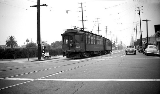
It's an area that was an "urban suburb" of streetcar corridors (The Pacific Electric on Venice, the Los Angeles Railway on Washington), houses, shops and houses of worship in popular early 20th-century aesthetic styles, with well-defined artistic pockets, both historic and contemporary. As usual, see you or not see you on the streets this Sunday!

1. Powers Place - Shortest Street in Los Angeles
1904
Powers Place and Alvarado Terrace, Pico-Union

You all know that the longest street in Los Angeles is Sepulveda Boulevard, right? But the shortest street in the city is right here! It's called Powers Place, a whopping 30 feet in length! Named after onetime Los Angeles City Council president (1900-1902) Pomeroy Powers, who spearheaded the effort to create a city park (originally named Terrace Park) at the neighborhood of Craftsman, Tudor and Victorian-style houses built in the early 1900s decade. All six historic houses along Alvarado Terrace were designated by the City as Historic-Cultural Monuments in 1971.


2. Iglesia Adventista Central/1st Church of Christ, Scientist
1912
1366 S. Alvarado Street, Pico-Union

Currently the site of a 7th Day Adventist Church catering to a Spanish-speaking congregation, this 107-year old Mediterranean Romanesque Revival house of worship has changed owners - even denominations - and has had a long, and even dark, history behind it. Built in 1912 as the 1st Church of Christ, Scientist, it served its Christian Science congregation for six decades, before it became a Jewish synagogue for a few years. In the mid-1970s, it became the Los Angeles location of The People's Temple, the cult founded by Jim Jones, who infamously led over 900 his followers to live in a commune in Jonestown, Guyana, and consequently, to die in the largest mass-suicide in history (which spawned the euphemism, "Don't drink the Kool-Aid"). The current Adventist church has been there since the late 1970s, since, Jim Jones uh...couldn't really use it anymore. The church structure was inducted into the National Register of Historic Sites in 1984.


3. Hoover Street - Original City Boundary
1850
Hoover Street, Pico-Union

The CicLAvia route begins/ends at this street, but note how all the streets east of Hoover run in a diagonal fashion, and all the streets west run perfectly east-west. Yes, Virginia, Los Angeles was not always big and sprawled. From 1850 to 1896, Hoover was the original western boundary of the City of Los Angeles, which meant that over 120 years ago, you'd be on the Westside. On April 2, 1896, the "Western Addition" was annexed into the City, extending the boundaries a few miles west to Arlington Avenue (more on this later...)


4. Loyola High School
1917
1901 Venice Blvd, Byzantine-Latino Quarter

Founded in 1865 at St. Vincent Court off of 7th Street in Downtown (a spot on the "Heart of LA" CicLAvia Tour), this Jesuit-run Catholic boys' high school is the oldest continuously-running educational institution in Los Angeles. The school moved to its current location in 1917 after splitting from the affiliated Loyola Marymount University, and after Irish philanthropist Thomas P. Higgins (who owned the Higgins Building on 2nd and Main in Downtown) donated land in what was then the southwestern corner of the city. Home of the Cubs, the school celebrated its sesquicentennial in 2015. Famous alums include volleyball great Sinjin Smith, Vons grocery founder Wilfred Von der Ahe, broadcaster Stan Chambers and holy Homeboy Fr. Greg Boyle.


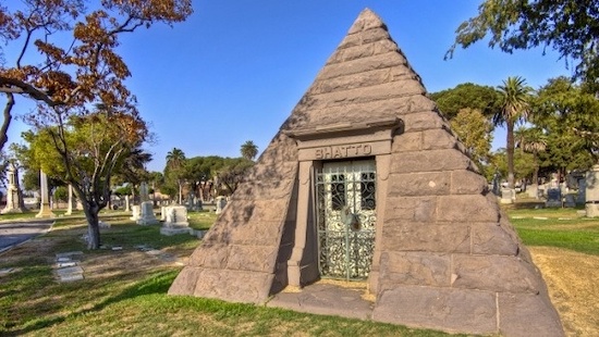
5. Angelus-Rosedale Cemetery
1884
1831 W. Washington Blvd, West Adams

This 65-acre memorial park, originally established as Rosedale Cemetery, has been serving Los Angeles for nearly 140 years, and is the final resting place of a number of historic Angelenos, such as Port of Los Angeles founder Phineas Banning, the City of Burbank's namesake Dr. David Burbank, jazz legend Eric Dolphy, actress Hattie McDaniel and mayors George Alexander, Arthur C. Harper, Owen McAleer, John G. Nichols, Frank Rader and Frederick T. Woodman. One of the most notable graves is that of Catalina Island developer George Shatto, who is interred in a pyramid (pictured above)!

6. Westmoreland Heights Tract Gateway
1902
Westmoreland Avenue and Venice Boulevard, Harvard Heights

In an era before cities erected standard street signs on corners, tract home developments established concrete or masonry gateway monuments bearing the name of the development as well as the street. This one bears the name of the Westmoreland Heights tract, established in 1899, featuring homes built in the Craftsman, Tudor/Craftsman and American Foursquare styles. Many of the residents were the owners of large local businesses. If you notice, the sign facing Venice Blvd bears the name "16th Street." West of Downtown, 16th Street is nowhere to be found on any maps (not even in La GuĂ­a de los Hermanos Tomas) - that's because 16th Street was re-named Venice Boulevard in 1932.

7. Ray Charles RPM International Studios
1964
2107 W. Washington Blvd, Harvard Heights.

Just a few blocks south of the CicLAvia route, this 11,488 square foot, two -story building, designed by Joe Adams and Ray Charles himself, opened in 1964 as the legendary musician's personal recording studio and offices (he lived in nearby Leimert Park at the time). One of his biggest hits, "Georgia On My Mind" was recorded here, as well as his 2004 Grammy-winning swan song album, Genius Loves Company. It was designated as a Historic-Cultural Monument by the City of Los Angeles in 2004, just prior to Charles' death, and since 2010 functions as the Ray Charles Memorial Library, a museum dedicated to the singer's career, featuring free tours of the facility (by appointment) on Mondays thru Wednesdays.


8. Arlington Ave - Old City Boundary
1909
Arlington Ave, Arlington Heights

Continuing the Los Angeles City Boundary history, Arlington Avenue was once the westernmost border of the City from 1896 to 1909, when the Colegrove Addition (which stretched north towards Hollywood) was annexed into the City. Note how the street dramatically widens west of Arlington - that, of course, was to accommodate both automobiles and the Pacific Electric Red Car tracks, which run the rest of the way along Venice Blvd.


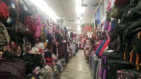
9. Washington Square Market/Swap Meet
1964
4060 Washington Blvd, Mid-City

This shopping center, built in the mid-1960s used to feature a Ralphs supermarket (hence the vestigal red oval sign) and local shops. Since the 1980s the shopping center has hosted an indoor swap meet, akin to the large Slauson Swap Meet in South Los Angeles, an indoor bazaar featuring clothing, shoes, sporting goods, repair/service stalls, salons and eateries owned by upstart immigrant entrepreneurs.


10. St. Paul's Catholic Church
1937
4120 Washington Blvd, Mid-City

Originally established on the site of a convent in 1917 among bean fields and oil derricks, the current Romanesque church building (inspired by the Basilica Papale San Paolo fuori le Mura in Rome) was built 20 years later and designed by famed Los Angeles architects John C. Austin and Frederick Ashley, who also designed the Griffith Observatory (which opened two years earlier). Today, St. Paul's serves a Spanish, English and Korean-speaking congregation.


11. Wellington Square
1914
Victoria Avenue, Wellington Road, Virginia Road and Buckingham Road (south of Washington Boulevard), Mid-City

Developed by M.J. Nolan on land formerly owned by George L. Crenshaw (Yup - that Crenshaw), this four-block neighborhood features over 200 Spanish Colonial, Tudor, French Norman, Craftsman and Revival-style residences. Today, the neighborhood is starting to get Capital "G," but you can check out their weekly Farmers' Market on the parking lot at Wellington Road and Washington Boulevard, also happening during CicLAvia Sunday (and every Sunday) between 9 a.m. and 1 p.m.


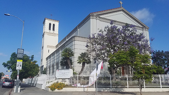
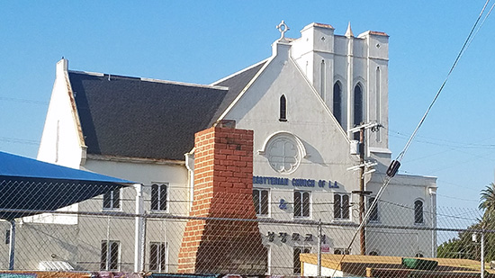
12. First Presbyterian Church of Los Angeles
1924
1809 West Boulevard, Mid-City

This Presbyterian church community, which moved several times around Los Angeles in its 136-year history, settled at this location in 1924. The congregation became predominantly African American in makeup in the 1960s, which it remains today, although the church shares the building with a separate Korean church. This Gothic Revival church structure was also designed by John C. Austin and Frederick Ashley (architects of St. Paul's down the street, remember?), along with Frederic Roehrig, who designed Pasadena's iconic Hotel Green. Check out the old-school incinerator chimney facing Washington Blvd!


13. Nate Holden Performing Arts Center/Ebony Showcase Theater
2004/1950
4718 Washington Blvd, Mid-City

Named after the longtime African American Los Angeles city councilman (1987-2002), this City-owned facility, which opened in 2004, hosts community-based performing arts and arts education programs. It was built on the site of the Ebony Showcase Theater, the first African American-owned theater building in Los Angeles, which was founded in 1950 by actor Nick Stewart (who voiced Brer Bear in Disney's "Song of the South") and his wife Edna. That theater featured community-based performing arts programs which ran until the 1998, when the City's Community Redevelopment Agency took over the Northridge earthquake-damaged building by eminent domain.


14. Trabue Pittman Building/Willing Workers Building
1931
4801 Washington Blvd, Mid-City

This Art Deco structure, built in 1931 at the northwest corner of Washington and Rimpau (where the Los Angeles Railway's W Line ended) was designed by celebrated architect S. Charles Lee. Owned by the Tabue Pittman Corporation, it was leased to various businesses over the years, including an F.W. Woolworth's store and a Bank of America branch. Today it is the home of Willing Workers, Inc, a non-profit that trains developmentally-disabled adults for workforce employment.


15. St. Elmo Village
1969
4830 St. Elmo Drive, Mid-City

This unique artists community was founded by the late African American artist Rozzell Sykes and his nephew Roderick, who purchased several homes in the neighborhood to save them from demolition and create a multicultural artists' community as an urban experiment. The community organizes the annual St. Elmo Festival every May to celebrate the arts. Over 50 years later, now run by Roderick Sykes, the community is still going strong.


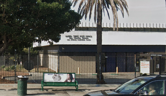
16. U.S. Post Office, West Adams Ray Charles Station
1983
4960 W. Washington Blvd, Mid-City

This post office building, which opened in 1983 and serves the 90016 ZIP code, was dedicated as the Ray Charles Station U.S. Post Office in August 2005, in memory of the one of neighborhood's most prominent figures, whose RPM International Studios is located just a mile and a half east (See #7 on this guide). The post office joins other facilities named after legendary musical artists, such as Nat King Cole on Western and 3rd and Marvin Gaye, on Vermont and 35th.

Happy CicLAvia!

BONUS: THE OFFICIAL MILITANT ANGELENO EPIC CICLAVIA TOUR FOOD GUIDE!


1. Dino's Chicken and Burgers
2575 W Pico Blvd, Los Angeles, CA 90006
www.dinoschickenandburgers.com

Get the Chicken and Fries. French fries, drenched in spicy grilled chicken grease. Served with cole slaw and tortillas. All for $7.95.

2. Papa Cristo's
2771 W Pico Blvd, Los Angeles, CA 90006
papacristos.com

They're one of the reasons (along with St. Sophia's Orthodox Church and the annual Greek Festival) for the "Byzantine" part in the Byzantine-Latino Quarter. One of Los Angeles' iconic long-time eateries for a Hellas-good meal.

3. Pupusa Stand

S. Bronson Avenue, south of Washington Boulevard, Mid-City.

Nice neighborhood sidewalk pupusa stand. Not guaranteed to be here during CicLAvia, but they're usually there on Sundays to serve churchgoers from across the street. Stop by to check it out!

4. Gish Bac
4163 W Washington Blvd, Los Angeles, CA 90018
gishbac.com

A nice Oaxacan option in Mid-City to get your mole on.

5. Simply D'Licious
4641 W Washington Blvd, Los Angeles, CA 90016
www.simplydliciousca.com

If Soul Food is what you're craving on CicLAvia Sunday, this is just the place, but don't be surprised if it's crowded or there's a line forming at the door, as it's already a popular local spot on normal Sundays.

6. Roscoe's House of Chicken and Waffles
1865 S La Brea Ave, Los Angeles, CA 90019
https://www.roscoeschickenandwaffles.com/

The classic, well-loved, presidentially-endorsed Pico location may now be gone, but this modern replacement for it is right here if you're craving some 'Scoes.

7. Leo's Tacos Truck
1515 South La Brea Ave, Los Angeles, CA 90019
leostacostruck.com

The O.G. location of what is regarded as the best Al Pastor in town, long lines form at the parking lot of this Sinclair gas station every evening, but you just might have a chance to get your trompo with the piña on the top with a shorter wait during CicLAvia.

Enjoy this Epic CicLAvia Tour guide? Show some support to The Militant Angeleno via PayPal!

Friday, March 31, 2023

Where The Wild (Flowery) Things Are: The Militant's Spring 2023 Southern California Wildflower Map!


A smattering of wildflowers in Walker Canyon near Lake Elsinore,
taken during the Spring 2019 Superbloom.

"L.A. has no seasons," goes the mantra of The Typical Transplant. But ah, why then are our mountain ranges green and not brown during the 2nd quarter of the year? Why are the stands of Dodger Stadium awash with blue again? And why does the sight of wildflowers attract people of all ages from young Instagram influencers to elderly grandparents?

It's wildflower season. It's the time when our native flora is present and alive. It's when humans go wild over the sight of countless plant genitalia. And we're blessed to have many areas that are not so far away from us where we can appreciate their ephemeral beauty. Do enjoy them now, for in a few months' time, the summer heat will dominate, the flowers will wither away, and the green will give way to golden brown. It's the Circle of Life, Simba.

The record winter rains have made our local wildflowers not only abundant, but have extended their season well into late April and perhaps May. The California Golden Poppy is the big star of the springtime show in this state, but other petals of red, white, purple, blue and yellow persuasions also make their presence known.

And so, The Militant has made a handy Google Map of the confirmed wildflower locations in Southern California - from San Luis Obispo County to San Diego County. All locations are based on personal, word-of-mouth and photographically-documented online observations. Do note that the addresses are based on the general publicly-accessible location (i.e. a park, nature preserve or hiking trail) and not necessarily the exact location of the blooms. But when you get there, the presence of the blooms should be obvious.


This map only includes areas where these flowers grow in the wild (hence, wildflowers - duh) and not any botanical gardens. Nothing against organized gardens, but it's more fun to see fish swim in the sea than in an aquarium, right?

This map is also continuously updated by The Militant several times a week, and certain locations known for wildflower blooms have not appeared on the map yet, because either the flowers have not yet bloomed, or The Militant has not yet seen or received reports of the bloom.

If you want to contribute to the map, shoot an email to The Militant (militantangeleno at gmail dot com) or send him a DM or @ on Twitter with a name and address of the location. If you're a wildflower-spotter and can ID the flowers, great! If you want, you can submit a photo and you'll get credit.

One more thing: Don't Doom The Bloom! Respect the marked trails and any property lines (if there are restricted areas). Don't step on the flowers! Nature is the main attraction here, not you! And Don't pick the flowers! They're not souvenirs, and they will quickly wilt anyway. Also, do note that not only have the flowers awoken from their winter hibernation, but so have the rattlesnakes. It's their home, not yours! Don't intrude on their area and they won't mess with you.

"But wait, Militant," you might ask, "Aren't you making things worse? These are closely-guarded secrets! They'll be ruined now that you're listing them all!" But au contraire - while the mainstream media only focuses on one location (as Lake Elsinore's Walker Canyon was back in 2019 - now it's currently closed to the public), the purpose of this map is to emphasize the fact that wildflowers are EVERYWHERE, and instead of focusing on one over-hyped location, The Militant is spreading out the crowds to other locations so that those other unsung locations can be appreciated and the handful of hyped-up "hot spots" won't be overloaded with crowds. You'll also notice that some areas, like the Antelope Valley and the southern Inland Empire have clusters of wildflower locations. You're strongly encouraged to make a day of it and visit them all! The Militant is doing a public service here!

Enjoy your spring superbloom, Southern California! And if you found this useful, help support The Militant Angeleno via PayPal!