
View The Militant Angeleno's CicLAvia Tour! in a larger map
Note: Though The Militant likes to view the route from west to east for some reason, he has listed these sites from East to West, as some of the sites are related and make a little more sense when going that direction.
The Militant does not like to repeat himself.
The Militant does not like to repeat himself.
The Militant got excited when an early CicLAvia flyer featured a small, yet historically significant branch was added to the route in Boyle Heights, from 4th & Boyle up the latter to the Mariachi Plaza area, but alas, it was an error.
So there's nothing new about this Sunday's route, other than some added media exposure and perhaps another hundred thousand participants. But now. we already have THE largest ciclovia/open streets event in the United States, so in your face, rest of America! We are Los Angeles, no other city can handle us!
The Militant wrote this up six months ago, but in case you may or may not have missed it the first time, here it is again - The Militant's Epic Militant CicLAvia Tour 2.0 - Redux!
Classic CicLAvia Route (Boyle Heights to East Hollywood)
 1. Hollenbeck Park
1892
4th and St. Louis streets, Boyle Heights
John Edward Hollenbeck was a rich dude in the late 19th century who founded the First National Bank of Los Angeles (more on this later) and purchased parcels of land in Downtown, the San Gabriel Valley and the Eastside, where he made his home. Hollenbeck was also credited with the creation of what is now called Exposition Park. His sister married his friend, James George Bell, who founded...Yep, you guessed it! After Hollenbeck's death in 1885, his widow, Elizabeth, donated a 21-acre parcel of land, which was essentially their front yard, to the City. One of the Los Angeles’ oldest parks, it was established in 1892 and continues to function today.
2. Hollenbeck Palms (Site of the Hollenbeck Residence)
1896
573 S. Boyle Ave, Boyle Heights
Take a quick detour from the CicLAvia route on 4th street and head down Boyle Ave a block and a half south.
1896
573 S. Boyle Ave, Boyle Heights
Take a quick detour from the CicLAvia route on 4th street and head down Boyle Ave a block and a half south.
On the site of this retirement facility, which directly dates back to the Hollenbecks' involvement, John and Elizabeth Hollenbeck made their home. The original Hollenbeck residence had a room built for the care of John's elderly father. After John's death, Elizabeth donated land she owned across the street (since visually separated from Boyle Ave in the 1950s due to construction of the 5 Freeway) for Hollenbeck Park and, in another act of philanthropy, created the Hollenbeck Home for The Aged on her property in 1896, offering free board and care for the residents for the rest of their lives. After Elizabeth's death in 1918, the Hollenbeck Trust operated the elderly home (modernized in 1985), and continue to run it today.
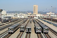 3. Metro Division 20 subway car yard and site of old Santa Fe LaGrande Station
1992 / 1893
320 S. Santa Fe Ave (visible from the 4th Street Viaduct), Arts District
Take a break from riding/walking/skateboarding/pogo-sticking/etc. and take a glance off the north side of the bridge from the west bank of the River. This facility is where the 104 Italian-built subway cars of the Metro Red and Purple line cars are stored, repaired, serviced and cleaned. This was also the temporary storage and repair site of the Angels Flight railway cars after the fateful 2001 accident. The Militant actually visited this facility back in May 1992.
The subway cars are also serviced on the site of the old Santa Fe Railway La Grande Station (hence the name of the street) that was on Santa Fe and 2nd. Built in 1893, it was precisely where midwestern transplants arrived in Los Angeles after paying their $1 train ticket from Chicago. In 1933, the landmark dome was damaged by the Long Beach Earthquake and subsequently removed. In 1939, it was rendered obsolete by the opening of the new Los Angeles Union Passenger Terminal a few blocks north.
4. Site of Quaker Dairy, Original Little Tokyo Restaurant
1890
304 E. 1st St., Little Tokyo
1890
304 E. 1st St., Little Tokyo
On the southeast corner of 1st and San Pedro streets once stood the Quaker Dairy, a restaurant started on this site in 1890 by Sanshichi Akita, an immigrant from Japan. Though preceded five years earlier by another restaurant on First St (location unknown), this is the oldest traceable location of a Little Tokyo business. By the end of the 19th century, there were over 16 Japanese-owned restaurants in this stretch of 1st Street, creating what we know as Little Tokyo.
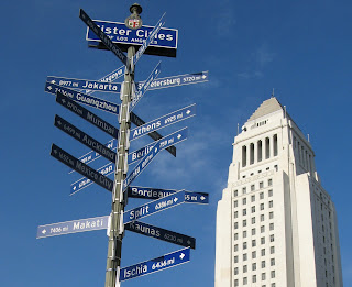 5. Los Angeles Sister Cities Monument
Circa late 1980s
1st and Main streets, Downtown
On the northeast corner of 1st and Main streets stands a pole bearing signs (in the "Blue Blade" style, no less) for every one of Los Angeles' 25 Sister Cities, each pointing towards their location. The signs range from Lusaka, Zambia (the farthest sister city, 10,017 miles) to Vancouver, Canada (the nearest, 1,081 miles) and everywhere in between. Nagoya, Japan is Los Angeles' oldest sister city (1959); Yerevan, Armenia is the newest (2007). Los Angeles, an Olympic host city (1932, 1984) also has that in common with sister cities Athens (1896, 2004), Berlin (1936), Mexico City (1968) and Vancouver (2010). Okay, the Militant is just filling up this paragraph with mindless trivia.
6. New Los Angeles City "Chevy Logo" Street Signs
2009
Various locations along 1st Street, Downtown
Speaking of Blue Blades, and since you're on 1st Street, don't forget to see Los Angeles' new street signs! Featuring a reflective background and typeface, the City Seal and shaped like the Chevrolet logo, these were the subject of The Militant's now-legendary recent post on Los Angeles street signs. Now you can see them for yourself!
7. Los Angeles Police Administration Building
2009
100 W. 1st St, Downtown
Having opened less than two years ago, there's nothing really historic about this building, but do stop and take a picture of City Hall's reflection from the facade's glass panel. It's like, the thing to do.
 8. Old State Office Building Foundation
1931 (Demolished 1971)
1st and Spring streets, Downtown
Ever wonder about that park-like area across the street from City Hall, and why there appears to be a foundation but no building? It was once the site of the State Office Building (pictured left, looking north on Spring), which was built in 1931. Forty years later, the 6.4 Sylmar Earthquake rendered it unsafe, and it was demolished. The land was once an openly-accessible parkspace; the Militant remembers going to a demonstration there as a child (Oh this Militant stuff sure started early...)
 9. Site of the Wilcox Building, First National Bank
1896
2nd and Spring streets, Downtown
Remember Mr. Hollenbeck? He be makin' serious bank! Oh wait, he literally did. As was mentioned, he founded a bank called the First National Bank of Los Angeles, which made its original home here on the southeast corner of 2nd and Spring in what once stood the Wilcox Building. Check this out: First National Bank merged with the Farmers and Merchants Bank to become the Security-First National Bank, which became Security Pacific National Bank (1967), and was eventually purchased by Bank of America in the 199os.
 10. Site of Hollenbeck Hotel
1884
2nd and Spring streets, Downtown
Man, this Hollenbeck dude got around! We're not quite through with him yet. Directly across Spring Street from the bank (on what is now a parking lot) stood the Hollenbeck Hotel, a pretty swanky, bougie inn back in the day. He owned not just the hotel, the entire block the hotel stood on (He sooo money!). As more hotels were being built in Downtown, this one eventually lost ground to its competitors and was demolished in 1933.
 11. Site of Original Ralphs Supermarket
1873
6th and Spring streets, Downtown
Before the Hotel Hayward building was built in 1905, George A. Ralphs (see, that's why there's no apostrophe) and his brother Walter B. started the Ralphs Bros. Grocers on the southwest corner of 6th and Spring. Their company still continues to this day, and in 2007, the company that started in DTLA returned to the area after some 50 years.
12. St. Vincent Court
1868
St. Vincent Ct and 7th Street, Downtown
You'd hardly knew it was there, but this alley nestled between Broadway and Hill (blink and you'll miss it!), with its decorative brick pavement and European decor, seemingly belongs to another world. Originally the site of a Catholic college that was the predecessor of today's Loyola Marymount University, today it's a unique food court featuring Armenian and Middle Eastern eateries. The Militant calls it, "Littler Armenia." Check out this Militant Angeleno post on St. Vincent Court from 2008 for more info!
13. Wilshire Grand Hotel
1952
7th and Figueroa streets, Downtown
What we see today as the now-closed Wilshire Grand Hotel is the latest in a long lineage of hotels that operated from that building. Originally built as the Los Angeles Statler Hotel (one of a dozen nationwide in that chain) in 1952, it became the Statler Hilton, then the Los Angeles Hilton, then the Omni Los Angeles Hotel, and finally the Wilshire Grand. Take a good look at this hotel, though - the hotel's owner, Korean Air Lines, will soon demolish it and put up a big-ass hotel with crazy-ass LED advertisements on the building in the next few years.
 14. City View Lofts/Young's Market Company Building
1924
1610 w. 7th St., Pico-Union
Ever wondered what's the deal with this 4-story Italian Renaissance-style building? It was built in 1924 as a liquor warehouse and original headquarters for Young's Market Company, which still operates today as the largest liquor distributor in the West. This building features actual marble columns and a decorative frieze made of terra cotta. The company, in the roaring, pre-depression 1920s, just felt like it. The building was looted and burned in the 1992 Riots and was rehabbed in 1997 to become the City View lofts. The building is in the National Register of Historic Places.
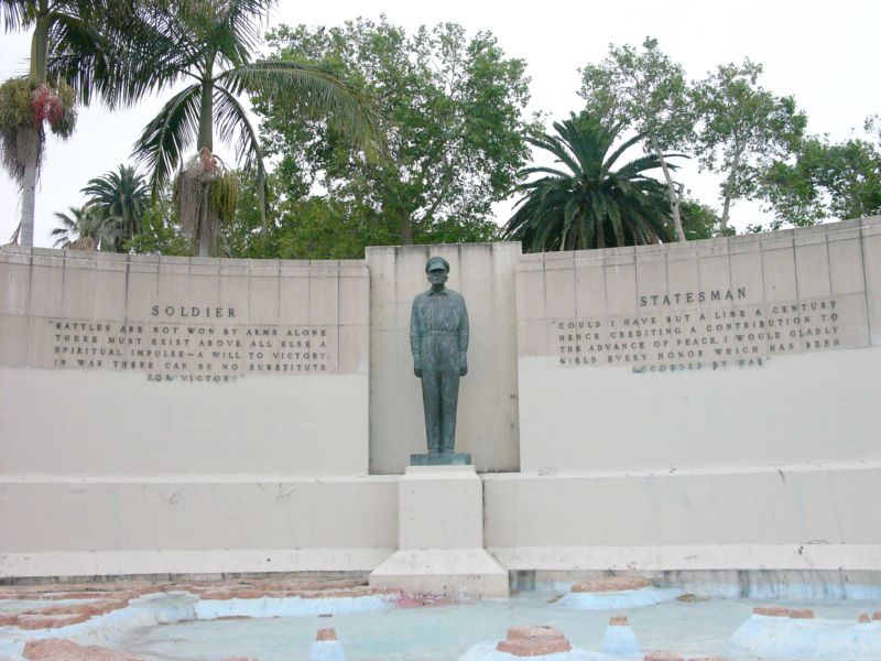 15. Gen. Douglas MacArthur Monument
1955
Southeast corner of MacArthur Park, Westlake
It's sort of strange how a monument to the park's namesake seems almost invisible (Gen John Pershing, MacArthur's WWI counterpart, could totally identify). In fact, most people don't know it's even there, but on the southeast shore of the lake is a dormant memorial fountain featuring a statue of the WWII general overlooking a model of the Pacific theatre (no, not that one) where he led allied forces to eventual victory. It was designed and built in 1955 by Roger Noble Burnham, who previously sculpted the Tommy Trojan statue on the USC campus and taught at the Otis Art School, formerly located nearby.
 16. Gen. Harrison Gray Otis Statue
1920
Northeast corner of Wilshire and Park View, Westlake
Gen. Otis is perhaps the most visible statue at the park, which predates MacArthur's WWII service. This general served in the Spanish-American and Philippine-American wars, and also fought as a Union soldier in the Civil War. But in Los Angeles, he is most known for being the founder, owner and publisher of the Los Angeles Times.
So why is he here? His Wilshire Blvd mansion, called The Bivouac, was located across the street, was later donated to Los Angeles County and became the original campus of Otis Art Institute. It's thought that his statue is pointing to the site of the Elks Lodge, but he's probably just pointing to his old house.
17. Nob Hill Towers/Old Nob Hill
c. Early 1900s
Ocean View Ave. and Carondelet St., Westlake
18. Can You Really See The Ocean?
Present Day
Ocean View Ave. and Park View St., Westlake
Allow yourself to veer off the CicLAvia route for a bit - From 6th St, head north on Coronado St for a few yards and make a right on Ocean View Ave to view a couple places covered in the Militant's January 2011 blog post on ritzy old Westlake.
On Ocean View and Carondelet, you'll find the Nob Hill Towers, the last vestige of what used to be known as Los Angeles' "Nob Hill." Bike up another block to Park View St, and if the sky is clear, look to the south and see if you can see the sea. On a clear day, you can see Catalina Island, for sure. If all else fails, you can still see the park, lol.
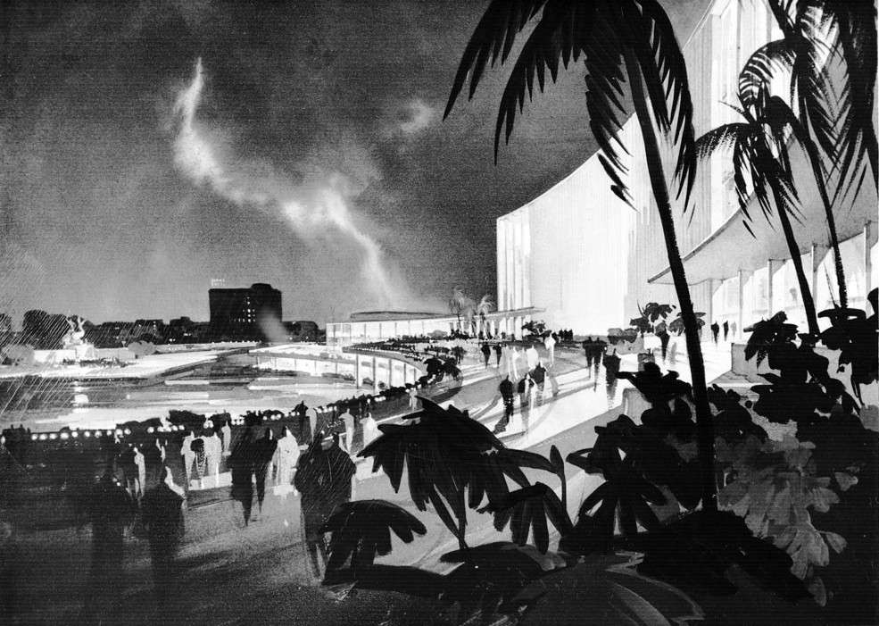
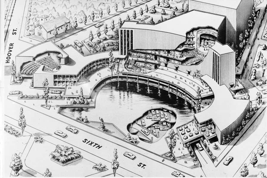 19. Formerly-Proposed Site of the Music Center
1950 (never built)
6th and Hoover streets, Westlake
Believe it or not, in 1950 there was a plan afloat to build a music and fine arts performance facility in Los Angeles...but not in Downtown. This proposal, complete with a concert hall, a theater, a man-made lake and several levels of underground car parking, was to have it located along 6th Street between Hoover Street and Lafayette Park Place. Sounds like a certain county supervisor at the time might have lived in the neighborhood. The Militant is soooo glad this didn't materialize. Some things were just never meant to be.
 20. Occidental Parkway
c. 1920s
Occidental Blvd between Hoover and Beverly, Westlake
Also covered in the Militant's post on old Westlake is Occidental Parkway, which is actually part of the City's park system. The palm-lined street with a median will take you northward to Beverly Blvd (If you're down for an Original Tommy's burger, head east on Beverly for a few blocks).
c. Early 1900s
Ocean View Ave. and Carondelet St., Westlake
18. Can You Really See The Ocean?
Present Day
Ocean View Ave. and Park View St., Westlake
Allow yourself to veer off the CicLAvia route for a bit - From 6th St, head north on Coronado St for a few yards and make a right on Ocean View Ave to view a couple places covered in the Militant's January 2011 blog post on ritzy old Westlake.
On Ocean View and Carondelet, you'll find the Nob Hill Towers, the last vestige of what used to be known as Los Angeles' "Nob Hill." Bike up another block to Park View St, and if the sky is clear, look to the south and see if you can see the sea. On a clear day, you can see Catalina Island, for sure. If all else fails, you can still see the park, lol.
19. Formerly-Proposed Site of the Music Center1950 (never built)
6th and Hoover streets, Westlake
Believe it or not, in 1950 there was a plan afloat to build a music and fine arts performance facility in Los Angeles...but not in Downtown. This proposal, complete with a concert hall, a theater, a man-made lake and several levels of underground car parking, was to have it located along 6th Street between Hoover Street and Lafayette Park Place. Sounds like a certain county supervisor at the time might have lived in the neighborhood. The Militant is soooo glad this didn't materialize. Some things were just never meant to be.
 20. Occidental Parkway
c. 1920s
Occidental Blvd between Hoover and Beverly, Westlake
Also covered in the Militant's post on old Westlake is Occidental Parkway, which is actually part of the City's park system. The palm-lined street with a median will take you northward to Beverly Blvd (If you're down for an Original Tommy's burger, head east on Beverly for a few blocks).
21. Visible Yellow Car Trolley Tracks (6th Street)
c. 1910s
6th Street and Commonwealth Ave
c. 1910s
6th Street and Commonwealth Ave
Look carefully through the paving in the middle of the street (west side of the intersection); you might just see a pair of 3 1/2-foot wide trolley tracks, once used by the 3 Line of the Los Angeles Railway's Yellow Cars. This line ran from east of Downtown to Larchmont Village and was abandoned in the late 1940s.
22. Location of Sacatela Creek
pre-1930
4th Street between Vermont Ave and Shatto Pl, Koreatown
Sacatela Creek was a natural stream that ran from the Franklin Hills south to what is now Koreatown and on to Ballona Creek The Militant wrote all about it back in April 2008 and it's one of his greatest posts ever. When you ride along 4th Street near Shatto Recreation Center, you are crossing what was once Sacatela Creek (which is actually buried in a drain pipe under the street).
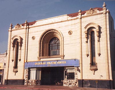
 23. Korean Philadelphia Presbyterian Church/Sinai Temple
1924
407 S. New Hampshire Ave, Koreatown
You've probably heard of people converting from Judaism to Christianity, but did you know buildings can, too? This building right at the route's turn at 4th and New Hampshire was established in 1924 by the Sinai Temple Conservative Jewish Congregation, which moved from here in 1960 to its current synagogue on Wilshire Blvd and Beverly Glen in Westwood. Look closely and you'll still see the Jewish imagery in the church's facade.
pre-1930
4th Street between Vermont Ave and Shatto Pl, Koreatown
Sacatela Creek was a natural stream that ran from the Franklin Hills south to what is now Koreatown and on to Ballona Creek The Militant wrote all about it back in April 2008 and it's one of his greatest posts ever. When you ride along 4th Street near Shatto Recreation Center, you are crossing what was once Sacatela Creek (which is actually buried in a drain pipe under the street).
23. Korean Philadelphia Presbyterian Church/Sinai Temple1924
407 S. New Hampshire Ave, Koreatown
You've probably heard of people converting from Judaism to Christianity, but did you know buildings can, too? This building right at the route's turn at 4th and New Hampshire was established in 1924 by the Sinai Temple Conservative Jewish Congregation, which moved from here in 1960 to its current synagogue on Wilshire Blvd and Beverly Glen in Westwood. Look closely and you'll still see the Jewish imagery in the church's facade.
 24. Little Bangladesh
 2010
3rd Street between New Hampshire and Alexandria, Little Bangladesh
Check it out, you're now in Los Angeles' newest designated community!
25. Godzilla Monument at Frank Del Olmo Elementary School
2006
100 N. New Hampshire Ave, Koreatown
Wait, what? Godzilla monument? At the front entrance of the school (named after the late Los Angeles Times columnist and editor), there's a plaque memorializing the location as the former site of Visual Drama studios, where in the mid-1950s the Japanese Gojira films were adapted for American audiences using Raymond Burr and other American actors. The result was 1956's Godzilla, King of the Monsters! The plaque credits this site as the birthplace of the American Godzilla films and pop culture phenomena.
 26. Visible Yellow Car Trolley Tracks (Heliotrope Drive)
c. 1915
Heliotrope Drive and Rosewood Avenue, Ambassador Hill
2006
100 N. New Hampshire Ave, Koreatown
Wait, what? Godzilla monument? At the front entrance of the school (named after the late Los Angeles Times columnist and editor), there's a plaque memorializing the location as the former site of Visual Drama studios, where in the mid-1950s the Japanese Gojira films were adapted for American audiences using Raymond Burr and other American actors. The result was 1956's Godzilla, King of the Monsters! The plaque credits this site as the birthplace of the American Godzilla films and pop culture phenomena.
26. Visible Yellow Car Trolley Tracks (Heliotrope Drive)c. 1915
Heliotrope Drive and Rosewood Avenue, Ambassador Hill
The Los Angeles Railway Yellow Car trolleys used to run through here; one line, called the H line, actually ran through Heliotrope Drive where the CicLAvia route runs. Today there is a community garden,which stands on what used to be the trolley's private right-of-way. Look at the ground towards the entrance to the garden - you can still see remnants of partially-buried tracks! Unfortunately, the street and sidewalk were repaved in 2010. Damn you, urban renewal! But the entire length of the community garden going all the way south to Beverly was the trolley's right-of-way. The Militant wrote about this site in a September, 2007 post. The H line continued to Downtown Los Angeles and ended at 63rd and Wall streets in South Los Angeles. The H line was abandoned on August 3. 1947.
 27. Ukrainian Culture Center/Jensen's Melrose Theatre
1924
4315 Melrose Ave, East Hollywood
The Ukrainian Culture Center of Los Angeles opened in 1961 to serve what was then a strong ethnic enclave - a Ukrainian church stands just four blocks east. Today it is a popular venue for quinceañeras. The Grammy-winning indie rock band Arcade Fire played a "secret" show here in February 2011, prior to picking up their award. This building was built in 1924 as "Jensen's Melrose Theatre" (one of a series of entertainment centers built by the Jensen brothers, whom also built one on Sunset Blvd in Echo Park), built for what was then an upper-class neighborhood located next to what was then UCLA (University of California, Southern Extension, now the Los Angeles City College campus). It was one of the last silent movie theatres built in the country, and operated until 1959. Take a look at the top of the facade -- the original name of the building is etched in concrete!
North and South Spurs
Added to the classic 7.5-mile route is the 2.5-mile stretch that was added in October 2011. Tons of history here!
El Pueblo Branch Route

1908
622 1/2 North Main Street, Downtown
This 103-year old building is the oldest vestige of what was once Los Angeles' Little Italy neighborhood. Built as a cultural center to serve the ethnic community, which has been present in the city since the 1820s, today, the well-restored structure, part of the El Pueblo De Los Angeles Historical Monument (a historical tour destination unto itself), is the site of Los Angeles' Italian American Museum, which will display artifacts and exhibits from the Little Italy district and the contributions of Italian Angelenos.

1825
You Can't Miss It
Los Angeles has (long exhale) often been criticized for not having a "center," The Militant countered with both an ancient center and a regional center. But The Plaza, for nearly two centuries (longer than any one of us has been here, right?), functioned as the undisputed Center of Los Angeles. Forever standing in the shadow of its tourist-heavy younger cousin Olvera Street (which you've all been to, so The Militant isn't adding it to his Epic CicLAvia Tour), The Plaza was really Los Angeles' own town square.
What's historic is not the hexagonal, wrought-iron bandstand (known as the Kiosko) -- that was built in the late 1940s as part of an urban renewal project for the El Pueblo district -- but the circular space itself, which was built in 1825 and actually functioned part-time as Los Angeles' first-ever sporting venue (bullfights were staged there in the 1800s). This was actually the third location of The Plaza. It was first established at the time of Los Angeles' founding 230 years ago, but much closer to The River. Flooding in the 1810s forced The Plaza to re-locate twice to higher ground. Hey, the third time's the charm...

c. 1830s-1960s
Aliso Street and Arcadia Street, Downtown
In addition to an Italian community, beleive it or non, Los Angeles had a French ethnic enclave, called The French Quarter. Before today's Hollywood Freeway trench and nearby parking lots was a bustling community of Franco-American businesses and institutions. When Frenchman Jean-Louis Vignes bought up land on the Yangna village site a few blocks east on Aliso Street, he essentially became the anchor of our French community. In 1912, businessman Marius Taix opened the Champ D'Or Hotel on Commercial Street and then opened his namesake restaurant in the same building in 1927. But the most famous constibution to our French Quarter was Philippe Mathieu's restaurant, which opened in various locations in the area. In 1918, his restaurant on 246 Aliso Street gave birth to The French Dip sandwich. But urban development (and cultural assimilation by the community) destroyed the French Quarter. In 1951, Philippe's moved a few blocks north to their present location on Alameda Street due to Hollywood Freeway construction, and Monsieur Taix's restaurant moved a decade later to Echo Park.

1975
Main and Temple Streets, Downtown
This $925,000 light-and-sound public art sculpture was designed by artist Joseph Young in the mid '70s as "a tribute to the unfinished, kaleidoscopic nature of Los Angeles." Intended to be Los Angeles' own iconic answer to the Eiffel Tower or The Statue of Liberty, it was also originally planned to be equipped with motion sensors and skyward-aiming laser beams. Budget constraints put a stop to that. Despite its shortcomings, it was the world's first public sculpture to integrate light and sound by use of a computer, something us 21st century types take for granted every day (cough LA Live cough).
The Triforium's lights are on daily from 6-8 a.m. and from 5-7 p.m. (6-8 p.m. PDT).
Though it's somewhat dated in its '70s-impression-of-the-future asesthetic (But hey, so is Star Wars), all it really needs to be hip to today's standards (it's already got its own Facebook page) is an iPod interface. Cultural Affairs Department, are you listening?
If continuing on to South Los Angeles, please refer to sites 5 to 11 above, then:
South Los Angeles Branch Route
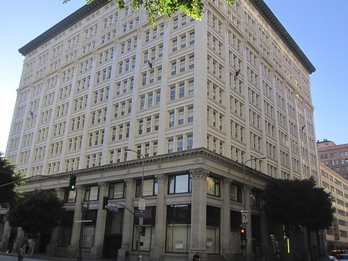
32. The I.N. Van Nuys Building
1911
210 W. 7th St (at Spring), Downtown
A 100-year old, 11-story Classical-style building built by banker and landowner Isaac Newton Van Nuys (who owned much of the San Fernando Valley, including his eponymous community). Designated as a Historic Cultural Landmark (#898) in 2007, what was once Los Angeles' most expensive office building ($1.25 million in 1911 dollars) was converted to senior housing. Do check out its unique parking structure, at 719-721 S. Spring St.
 33. Great Republic Life Insurance Building
1927
756 S. Spring St., Downtown
The Militant just loves old buildings with their names imprinted on their front and ornate bas-relief designs in the upper financial floors. This 13-story Beaux Arts style building is one of those, home to the Great Republic Life Insurance company, built right before the Great Dperession. This and many other financial institutions up and down Spring Street were part of the "Wall Street of the West." And since this is 2011, think of CicLAvia as #OccupyWallStreetOfTheWest. Today, it's home to the Great Republic Lofts.
 34. National City Bank Building
1924
810 S. Spring St., Downtown
Another fine example of 1920s Beaux Arts architecture is the National City Bank (not to be confused with the City National Bank) Building. They just don't make 'em like this anymore. Today, it's home to the National City Tower Lofts.
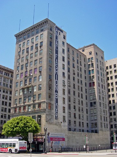 35. ANJAC Fanshion Buildings
Built various years in the 20th Century
Various Locations along Broadway, Spring and Santee Streets, Downtown
The ANJAC Fashion Buildings (you'll see a whole bunch of 'em) are a collection of older buildings re-purposed for use as rented showroom, warehouse or manufacturing spaces for the local clothing industry. They're all owned by Steve Needleman, who also owns the nearby Orpheum Theatre. One of the ANJAC buildings on nearby Broadway was the site of an historic 3-week garment worker's strike in 1933 that put Chicano organized labor on the map.
 36. Spring/Main Junctionc 1890s
Spring and Main Streets at 9th Street, Downtown
This very Manhattanesque portion of Downtown Los Angeles might not be The Great White Way, but it did serve as a junction point for both the Pacific Electric and Los Angeles Railway trolleys back in the day. The triangular park in the middle, recently ornamented with public art once served as a passenger platform for the streetcars. The building at the very tip of the corner, just north of it was once the local Anheuser Busch brewing company headquarters. More historical pics here, here, here and here.
 37. Harris Newmark Building
This 12-story building was at one time the tallest building in Los Angeles, built in honor of Harris Newmark, an early Los Angeles leader, businessman, landowner and philathropist. He helped to found the city of Montebello and helped shape Los Angeles' Jewish community through his leadership and charitable giving. It was once home to Sam's Deli, a local eatery institution that operated from 1963 to 2003. In the '90s, the building was carefully restored using the original blueprints. It now functions today as The New Mart (get it?)
9th and Cecilia streets, Downtown
Now here's a sight that longtime Angelenos haven't seen in a long time - the interlocking "S" logo of Security Pacific National Bank. Once upon a time, there were actually large banks founded and headquartered in Los Angeles. Security Pacific, a major bank whose heritage dates back to 1868 was swallowed up by the big, evil Bank of America in 1992. The Militant discovered recently that this apparent vestige of days gone by is actually more recent, as a new but unrelated Security Pacific began in 2005 and went out of business just three years later (the bank space in this building is vacant and currently available for lease). Judging by the condition of the sign, this may or may not be the case.
39. Dude, Where's My 9th Street?
1928
9th Street-Olympic Blvd at Ceres Ave.
Chalk this one up, along with the two San Vicente Boulevards, as one of the great street mysteries of Los Angeles. While heading east on 9th Street, the thoroughfare inexplicably becomes Olympic Boulevard, only to vanish into oblivion. Olympic, on the other hand, resurfaces west of San Julian and heads all the way Santa Monica's 5th Street. The Militant is only announcing this as a public service just so you won't think anyone was f'ing with your mind as you head east on 9th.
1227 E. Olympic Blvd, Downtown
This wholesale market operated in partial competition to the much larger wholesale market just a few blocks east, but it's in a supplementary role nowadays as a wholesale meat and poultry facility.
Central and Olympic Blvd, Downtown
Anyone who says Los Angeles, or even Downtown Los Angeles, isn't a 24-hour city, has obviously never been here. From about 2 a.m. to 2 p.m. (the action begins at 4 a.m. and ends before 10 a.m.), trucks roll up to unload fresh-from-the-farm produce in bulk for purchase. This market is mostly for supermarkets, distributors and restaurants, but anyone can purchase at the vendors here (you just have to take home a big-ass crate of apples rather than just a couple pounds). The Grand Central Market performed this role all but briefly before it was maxed out, and a new produce market, on 7th and Central was built closer to the railroad tracks in 1918. In 1986, the facility was expanded to what you see today. Check out this YouTube video of how the market looked like in 1963!
12th Street at Central Avenue, Downtown
Look at the cracks and crevices in the street, just east of the crosswalk: TRACK! These tracks carried the Yellow Cars of the Los Angeles Railway's 2 Line, which ran from South Central through Downtown to the City Terrace area in The Eastside. Look carefully and you can see the old school inlaid brickwork in between the tracks! And unlike #26 above, the tracks are verified to be there!
1936
1334 S. Central Ave, Downtown
Coca-Cola has been locally bottled in Los Angeles since 1895, with about five different locations in the Downtown area throughout history. But this is by far the most recognizable. A ship-like design by Robert Derrah (who also crafted Hollywood's likewise-nautical-flavored Crossroads Of The World) makes this one of Los Angeles' most unique buildings. And they'll be handing out free Coke and related beverage samples!

1401 S. Central Ave, Downtown
Originally built as LAFD fire station 30, it was one of two "Blacks Only" stations between 1924 and 1955, when the fire department was integrated and the station de-commissioned. In 1997 the building was converted into a museum to celebrate the contributions of African Americans in the LAFD and to highlight the long and painful struggle to integration and racial equality. The LAFD of today has a black Fire Chief, which would never have been possible without the struggles, stories and service of the people recognized at this museum. Definitely check it out.
Whoa, that's a lot of history and interesting sites for just 2 1/2 miles! But do enjoy this, appreciate Los Angeles more and have a great time at CicLAvia on Sunday!
To download and print a copy of this tour guide or send to your unspecified tablet computing device to take with you on your ride on Sunday, please click here! (Go to File | Print (PDF) in the Google Docs window)
210 W. 7th St (at Spring), Downtown
A 100-year old, 11-story Classical-style building built by banker and landowner Isaac Newton Van Nuys (who owned much of the San Fernando Valley, including his eponymous community). Designated as a Historic Cultural Landmark (#898) in 2007, what was once Los Angeles' most expensive office building ($1.25 million in 1911 dollars) was converted to senior housing. Do check out its unique parking structure, at 719-721 S. Spring St.
1927
756 S. Spring St., Downtown
The Militant just loves old buildings with their names imprinted on their front and ornate bas-relief designs in the upper financial floors. This 13-story Beaux Arts style building is one of those, home to the Great Republic Life Insurance company, built right before the Great Dperession. This and many other financial institutions up and down Spring Street were part of the "Wall Street of the West." And since this is 2011, think of CicLAvia as #OccupyWallStreetOfTheWest. Today, it's home to the Great Republic Lofts.
1924
810 S. Spring St., Downtown
Another fine example of 1920s Beaux Arts architecture is the National City Bank (not to be confused with the City National Bank) Building. They just don't make 'em like this anymore. Today, it's home to the National City Tower Lofts.
Built various years in the 20th Century
Various Locations along Broadway, Spring and Santee Streets, Downtown
The ANJAC Fashion Buildings (you'll see a whole bunch of 'em) are a collection of older buildings re-purposed for use as rented showroom, warehouse or manufacturing spaces for the local clothing industry. They're all owned by Steve Needleman, who also owns the nearby Orpheum Theatre. One of the ANJAC buildings on nearby Broadway was the site of an historic 3-week garment worker's strike in 1933 that put Chicano organized labor on the map.
Spring and Main Streets at 9th Street, Downtown
This very Manhattanesque portion of Downtown Los Angeles might not be The Great White Way, but it did serve as a junction point for both the Pacific Electric and Los Angeles Railway trolleys back in the day. The triangular park in the middle, recently ornamented with public art once served as a passenger platform for the streetcars. The building at the very tip of the corner, just north of it was once the local Anheuser Busch brewing company headquarters. More historical pics here, here, here and here.
1925
127 E. 9th St., DowntownThis 12-story building was at one time the tallest building in Los Angeles, built in honor of Harris Newmark, an early Los Angeles leader, businessman, landowner and philathropist. He helped to found the city of Montebello and helped shape Los Angeles' Jewish community through his leadership and charitable giving. It was once home to Sam's Deli, a local eatery institution that operated from 1963 to 2003. In the '90s, the building was carefully restored using the original blueprints. It now functions today as The New Mart (get it?)
38. Security Pacific Bank(!)
c 1990s or 2000s9th and Cecilia streets, Downtown
Now here's a sight that longtime Angelenos haven't seen in a long time - the interlocking "S" logo of Security Pacific National Bank. Once upon a time, there were actually large banks founded and headquartered in Los Angeles. Security Pacific, a major bank whose heritage dates back to 1868 was swallowed up by the big, evil Bank of America in 1992. The Militant discovered recently that this apparent vestige of days gone by is actually more recent, as a new but unrelated Security Pacific began in 2005 and went out of business just three years later (the bank space in this building is vacant and currently available for lease). Judging by the condition of the sign, this may or may not be the case.
1928
9th Street-Olympic Blvd at Ceres Ave.
Chalk this one up, along with the two San Vicente Boulevards, as one of the great street mysteries of Los Angeles. While heading east on 9th Street, the thoroughfare inexplicably becomes Olympic Boulevard, only to vanish into oblivion. Olympic, on the other hand, resurfaces west of San Julian and heads all the way Santa Monica's 5th Street. The Militant is only announcing this as a public service just so you won't think anyone was f'ing with your mind as you head east on 9th.
40. Central Market
c 1930s1227 E. Olympic Blvd, Downtown
This wholesale market operated in partial competition to the much larger wholesale market just a few blocks east, but it's in a supplementary role nowadays as a wholesale meat and poultry facility.
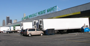
41. Los Angeles Wholesale Produce Market
1918, expanded in 1986Central and Olympic Blvd, Downtown
Anyone who says Los Angeles, or even Downtown Los Angeles, isn't a 24-hour city, has obviously never been here. From about 2 a.m. to 2 p.m. (the action begins at 4 a.m. and ends before 10 a.m.), trucks roll up to unload fresh-from-the-farm produce in bulk for purchase. This market is mostly for supermarkets, distributors and restaurants, but anyone can purchase at the vendors here (you just have to take home a big-ass crate of apples rather than just a couple pounds). The Grand Central Market performed this role all but briefly before it was maxed out, and a new produce market, on 7th and Central was built closer to the railroad tracks in 1918. In 1986, the facility was expanded to what you see today. Check out this YouTube video of how the market looked like in 1963!
42. Yellow Car Tracks
c. early 1900s12th Street at Central Avenue, Downtown
Look at the cracks and crevices in the street, just east of the crosswalk: TRACK! These tracks carried the Yellow Cars of the Los Angeles Railway's 2 Line, which ran from South Central through Downtown to the City Terrace area in The Eastside. Look carefully and you can see the old school inlaid brickwork in between the tracks! And unlike #26 above, the tracks are verified to be there!
 |
| I'M ON A BOAT! (Sorta...) |
1334 S. Central Ave, Downtown
Coca-Cola has been locally bottled in Los Angeles since 1895, with about five different locations in the Downtown area throughout history. But this is by far the most recognizable. A ship-like design by Robert Derrah (who also crafted Hollywood's likewise-nautical-flavored Crossroads Of The World) makes this one of Los Angeles' most unique buildings. And they'll be handing out free Coke and related beverage samples!
44. African American Firefighter Museum (Fire Station 30)
1913, 19971401 S. Central Ave, Downtown
To download and print a copy of this tour guide or send to your unspecified tablet computing device to take with you on your ride on Sunday, please click here! (Go to File | Print (PDF) in the Google Docs window)
No comments:
Post a Comment