Tuesday, December 21, 2021

32 More Suburbs in Search of Their Names: An Etymology of Cities in the Inland Empire


Wow, it's been a while since The Militant did something like this. Er, not just post something on This Here Blog Site that has nothing to do with an Epic CicLAvia Tour, but making a post about the name origins of places in Southern California.

It all started in November 2013, when The Militant made a pretty epic post about how all 88 of Los Angeles County's incorporated cities got their names. He then decided to follow it up in April 2014 with the name origins of Orange County's 34 incorporated cities (do read those if you missed them the first time...).

This time around, for some odd reason, he wanted to take on the Inland Empire, which is not a county per se, but a region of varying sizes and definitions. Most define the Inland Empire as two counties, some folks include parts of five. Since one of those counties includes the largest county in the United States in terms of geographical size (though the state of Alaska has county-like bodies called "boroughs" which are even larger), The Militant doesn't want to bother with having to go all the way out to MF'ing Zzyzx, so for the sake of this, and the relevancy to his (greater) Los Angeles jurisdiction, The Militant will define "Inland Empire" as "The parts of San Bernardino and Riverside counties that exist within the Los Angeles Basin and the greater Los Angeles Metropolitan Area that are not situated in the Mojave or Colorado deserts." So...Palm Springs, Victorville - you cool, but sorry, you ain't part of this.

The Inland Empire, a.k.a. The I.E. was actually known for years as "The Orange Empire," being part of a large swath of Southern California that included the San Gabriel Valley and Orange County known for its orange groves and citrus production. A regional annual citrus-themed fair called the National Orange Show has been taking place in San Bernardino since 1889. But the dynamics of the area had evolved over the years, as Los Angeles became more urbanized and the mass media market defined by radio, television, newspapers, transportation infrastructure and professional sports teams blanketed the region, the Orange Empire became more known as a suburb.

On November 14, 1992, a large part of the 714 telephone area code split off and became the 909 area code. That gave the suburban region east of Los Angeles anchored by the twin cities of San Bernardino and Riverside a much stronger regional identity, and the term "Inland Empire," (which dates back to 1914 as documented in the old Riverside Enterprise newspaper) garnered more usage locally and nationally (especially since a neighboring region had already gained more association with the name "Orange").

So while The Militant's previous two lists were limited to incorporated cities within counties, due to the nature of the I.E., this list will also include unincorporated areas and notable communities of incorporated cities. Because the Inland Empire is like that. Also, since Lake Arrowhead and Big Bear Lake are not topographically part of the Inland Empire, because of their recreational nature, they are just as connected to the Metropolitan Los Angeles area as the towns down below, so they made the list.

As typical with Southern California place names, there's a lot of Español, especially in terms of Mexican Rancho origins, as well as names of white dudes who founded that particular place, but there are also names of French, Italian and Danish origin, as well as indigenous origin, from the three Native American tribes in the region (as well as one well outside the I.E.).

So without further delay, and after much Militant research, here it is, the etymology of 32 places in the Inland Empire, in alphabetical order:

Big Bear Lake – The California grizzly bears that once lived in the area.

Chino - Originally part of the Mexican land grant Rancho Santa Ana del Chino (“Ranch of St. Anne of the Curls”); the “curls” refer to the curly grama grasses that grow in the valley.

Chino Hills – See Chino.

Colton – David Colton, vice president of the Southern Pacific Railroad, the company that built a large railroad yard in the city that remains in operation today.

Corona – Spanish for “crown”; the nickname of the one-mile diameter circular road (Grand Blvd) in the town’s center.

Etiwanda – The Etiwanda Native American tribe, which lived on the shores of Lake Michigan.

Fontana – Italian for “fountain” or “water source”; located near the Santa Ana River.

Hemet – Named after the Lake Hemet Land Company. There are several competing origins on the name “Hemet,” including the local Native American word for “box,” and the Hemmet Brothers, Scandinavian immigrants who settled in the area.

Highgrove – Originally named East Riverside, was renamed in 1897 after the local orange groves and to give it a separate identity from Riverside.

Highland – The area east of San Bernardino, higher in elevation (300’) than the rest of the city.

Jurupa Valley – Originally part of the Rancho Jurupa Mexican land grant.

Lake Arrowhead – Originally named “Little Bear Lake” (in reference to its fellow alpine reservoir to the east), it was re-named by the Arrowhead Lake Company after the natural rock outcropping overlooking San Bernardino that visually resembles an arrowhead.

Lake Elsinore – [Competing origins] 1) After the Danish city of Helsingør in William Shakespeare’s Hamlet; 2) Anglicization of Spanish “El señor”.

Loma Linda – Spanish for “pretty hill.”

Ontario – The Canadian province of Ontario, where city founders and brothers George, William and Charles Chaffey originated from.

Menifee – Luther Menifee Wilson, a miner who discovered quartz in the area in the 1880s.

Mentone – The town of Menton in southeastern France.

Montclair – Originally named “Monte Vista” in 1900, was officially named “Montclair” in 1958 as a result of a request by the US Postal Service to avoid confusion with the Monte Vista in northern California; also as a phonetic reference to neighboring Claremont.

Moreno Valley – Spanish for “brown;” a reference to Frank Brown, the co-founder of Redlands.

Murrieta – Brothers Juan and Ezequiel Murrieta, co-owners of the Rancho Temecula Mexican land grant.

NorcoNorth Corona Land Company, which first developed the town.

Perris – Fred T. Perris, chief engineer (as in designer, not train operator) of the Atchison, Topeka and Santa Fe Railway, who oversaw construction of the transcontinental railroad line between Chicago and Los Angeles along the Cajon Pass in 1885.

Rancho Cucamonga – The Tongva village of Kukamogna ("Place of the sand").

Redlands – The color of the local reddish soil, used for making adobe.

Rialto – The Ponte di Rialto (Rialto Bridge) in Venice, Italy.

Riverside – Alongside the Santa Ana River.

Romoland – Originally named Romola Farms, the name was changed due to a request by the US Postal Service to avoid confusion with Ramona, CA.

San Bernardino – San Bernardino de Siena Asistencia (or Estancia) (St. Bernardine of Siena homestead), an outpost of San Gabriel Mission established by Spanish settlers.

TemeculaTemeekunga, meaning “place of the sun” in the language of the indigenous Luiseño/Payómkawichum people.

Upland – The area north, or “up land” of Ontario; also a reference to the height of nearby Mt. San Antonio (a.k.a. Mt. Baldy).

Wildomar – Portmanteau of the names of the town’s founders: William Collier, Donald Graham and Margaret Collier Graham.

YucaipaYukaipa’t, meaning “green valley” in the language of the indigenous Serrano/Taaqtam people.

Saturday, December 4, 2021

The Militant's Epic Militant CicLAvia Tour XXXVIII!


Interactive Map! Click on green points to view hotspots, or click here for larger view.


Looks like we made it - Sunday's "South L.A." CicLAvia is the third and last CicLAvia of 2021, a year that seemed to go by oh so fast. But it was great to return to the open streets this year, wasn't it? This time around, the 38th edition of Los Angeles' open streets event features a modified version of the December 7, 2014 CicLAvia. Instead of running down Central Avenue (the historic Main Street of Black Los Angeles), we have a 5.3-mile route that begins at Central and heads west along Dr. Martin Luther King Jr. Boulevard. Instead of running south towards Leimert Park, we head north on Crenshaw Boulevard (the contemporary Main Street of Black Los Angeles). The 23-mile street was named in 1904 after banker and developer George Lafayette Crenshaw, who developed the Lafayette Square and Wellington Square neighborhoods near Washington Blvd and his namesake thoroughfare. In addition to being the center of Los Angeles' modern-day Black community, particularly in Leimert Park, Crenshaw once was home to a Japanese American community. The exceptional width of both Martin Luther King and Crenshaw boulevards has supported automobiles, streetcars (and soon, light rail) and even a space shuttle. And now, it'll host bicycles, skateboards, scooters, wheelchairs, strollers, runners and pedestrians. Hopefully if The Rona doesn't get out of control next year, we'll have more of these again in '22.

Stay safe, stay healthy and see you or not see you on the streets this Sunday!


1. Ralph J. Bunche House
1919
1221 E. 40th Place, South Los Angeles

The Central Avenue corridor was home to Los Angeles' black community, primarily due to the racial covenants that restricted them from owning homes elsewhere in the city. But great things can come from places of injustice. Ralph J. Bunche was a teenager arriving with his family from Detroit, by way of Ohio and New Mexico, who attended nearby Jefferson High School and went to UCLA, graduating as the valedictorian at both schools. He went on to Harvard, where he earned his Ph.D in Political Science (the first African American to receive a doctorate in PoliSci from a U.S. university), and later was one of the founders of the United Nations. In 1950, due to his diplomatic work in the negotiations that ended the 1948 Arab-Israeli War, he won the Nobel Peace Prize -- the first nonwhite person to ever win the esteemed award. And he once lived right here, just two blocks east of the CicLAvia route.

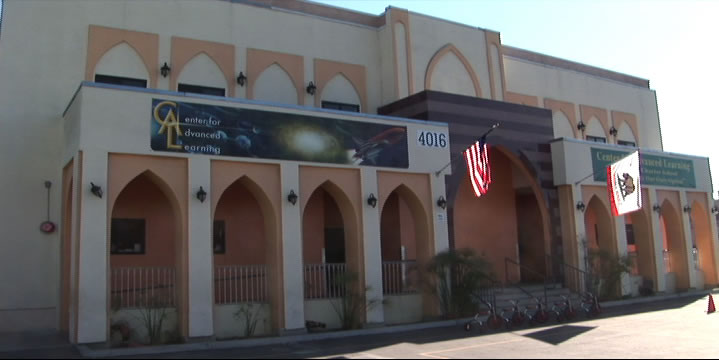
2. Masjid Bilal Islamic Center/Site of Elks Lodge
1929
4016 S. Central Ave, South Los Angeles

This mainstay of the local Muslim community since 1973 also has a deep history in the local black community. The building was originally built in 1929 as the home of the local Elks club. But it was no ordinary Elks Club (who discriminated against black membership). It was run by the Improved and Benevolent Protective Order of Elks of the World, an African American-run organization founded in Cincinnati, Ohio in 1898 that functioned as a fraternal order for people of color. Though obviously not directly affiliated with the white Elks club, it is run with the otherwise identical customs and traditions, and with nearly half a million members worldwide, is the largest black fraternal organization in the world.

3. Site of Wrigley Field
1925  (demolished 1969)
Avalon Blvd & 42nd Place

Just a few blocks south of the CicLAvia route is Gilbert W. Lindsay Park, named after Los Angeles' first African American city councilman. But years ago, this was the place where home runs, strikeouts and 7th Inning Stretches took place in the City of Angels. And yes it was a city of Angels, as the Los Angeles Angels of the Pacific Coast League made the 22.000-capacity Wrigley Field (named after the chewing gum magnate, who had several stakes in Southern California, including Catalina Island) its home. And as any truly militant Angeleno knows, the ivy-and-brick Chi-town tourist trap, though 11 years older, was originally called Weeghman Park and wasn't dubbed Wrigley Field until 1927, which made Los Angeles' Wrigley Field the first Wrigley Field ever. The stadium also was popular with TV and movie shoots, such as Damn Yankees and The Twilight Zone. In 1961, it literally went Major League as the American League expansion team Los Angeles Angels of Los Angeles played its home games there before moving to Dodger Sta, er, Chavez Ravine for the next four seasons, and then finally moving down the 5 to Anaheim. Wrigley Field was also home of the Los Angeles White Sox, a club in the short-lived, 6-team West Coast Negro Baseball Association, a Black minor league co-founded by Olympic gold medalist Jesse Owens which lasted but a single season in 1946. Yes, there's a baseball field in the park, but it's not the same location as the original diamond.

4. Banc of California Stadium
2018
3939 S. Figueroa St, Exposition Park

Home of the MLS' Los Angeles Football Club soccer team, this $350 million, 22,000-seat venue is the first open-air stadium to be built in the City of Los Angeles since Dodger Stadium opened in 1962. It was built on the former site of the 16,000-seat Los Angeles Memorial Sports Arena (1959-2016), which was the first Los Angeles home of the Lakers (1960-1967), the Clippers (1984-1999) and hosted the Boxing matches during the 1984 Olympics. In 2022, Banc Stadium will also become the home venue of the Angel City FC National Women's Soccer League team in 2022 and host the Men's and Women's Soccer tournaments during the 2028 Olympics.

5. Historic Southern Pacific Palm Tree
 Re-planted 1914
3901 S. Figueroa St, Exposition Park

Back in the late 1800s-early 1900s, the Southern Pacific Railroad operate out of a train station called the Arcade Station, on 5th and Alameda streets. A lone palm tree stood outside the station and functioned as a landmark for arriving passengers coming in from San Francisco or points east. In 1914 (dude, a hundred years ago) the Arcade Station was demolished (no, it wasn't consumed by a fire) to make way for a more modern station, called Central Station, and the palm tree had to go. So sentimental was the palm tree, instead of being cut down, it was moved to Exposition Park, where it has stood ever since. Like its neighbor the Space Shuttle Endeavour, it was a popular icon back in its day, and it's probably safe to assume that its transport through town was an event in itself. A little-known historic market at the base of the tree tells the whole story. So if you want to see a palm tree that was planted there over 100 years ago, there you go.

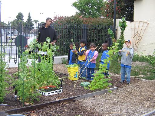
6. Community Services Unlimited Urban Garden
2003
Bill Robertson Lane and Martin Luther King Jr Blvd, Exposition Park

Did you know there's an urban garden along the CicLAvia route? Local nonprofit Community Services Unlimited (an organization that, interestingly enough, originated from the Black Panther Party's community outreach programs in the 1970s) grows their own organic fruits and vegetables in this Exposition Park urban garden that they sell and distribute in this predominantly food desert area to help local residents gain access to fresh, healthy produce. They sell this produce at a stand outside the LA84/John C. Argue Swim Stadium next door on Thursday afternoons from 3 to 6 p.m.

7. Los Angeles Swimming Stadium
1932
Bill Robertson Drive & Park Lane, Exposition Park

The Coliseum's little brother, the Los Angeles Swimming Stadium was the 10,000-seat venue for the 1932 Olympic swimming, diving and water polo competitions, as well as the aquatic portions of the pentathlon event. Olympians such as Buster Crabbe swam in its waters. After the games, it became a public pool, and in the '50s, USC's swim team used it as their training and competing venue. After over a half century of wear, and damage from the 1994 Northridge Earthquake, the swim stadium was renovated in 2002 and operates today as the LA84 Foundation/John C. Argue Swim Stadium.
Marco...Polo!

8. George Lucas Museum of Narrative Art
2023
Vermont and 39th St, Exposition Park

Taking shape on west side of Exposition Park like a Naboo Royal Starship is the George Lucas Museum of Narrative Art (or, "The Luke," as The Militant would like to call it), a state-of-the-art visual, cinematic and interactive museum founded by 'Star Wars' creator and filmmaker George Lucas and his wife Mellody Hobson. The site, located in close proximity to Lucas' alma mater, USC, beat out other site proposals in San Francisco (home of Lucasfilm, Ltd) and Chicago (Lucas' birthplace) when it was announced in 2017. Originally intended to open this year, it was delayed to 2023 due to the COVID-19 pandemic.

9. Celes King III Bail Bonds
1949
1530 Martin Luther King Jr Blvd, Vermont Square

Why is a Bail Bonds joint listed in the Militant's CicLAvia tour? WTF? Well, before 1983, this street was known as Santa Barbara Avenue. Celes King III was the person who lobbied to change the name of the street to Martin Luther King Jr (no relation) Blvd. A real estate broker, bail bondman, outspoken Republican, former Tuskeegee Airman, failed City Council candidate, co-founder of the Brotherhood Crusade and founder of the Kingdom Day Parade, he successfully lobbied the L.A. City Council in 1983 to re-name Santa Barbara Ave. after the slain civil rights leader -- albeit not without controversy. Some of his critics accused him of doing it to irritate then-Mayor Tom Bradley, one of his political enemies, and others have criticized CK3 of conflict of interest (his residence (he lived in the apartment upstairs) and his bail bonds business were located on Santa Barbara Ave after all) and even ego trippin' (the short-hand street signs say "King Bl"-- the same as his own last name). Whether this was a self-aggrandizing stunt or a genuine tribute to an American hero, we will never know: Celes King III died in 2003. But here's one interesting CicLAvia route fact: His father, Celes King, Jr was the owner of Central Avenue's Dunbar Hotel back in its heyday.
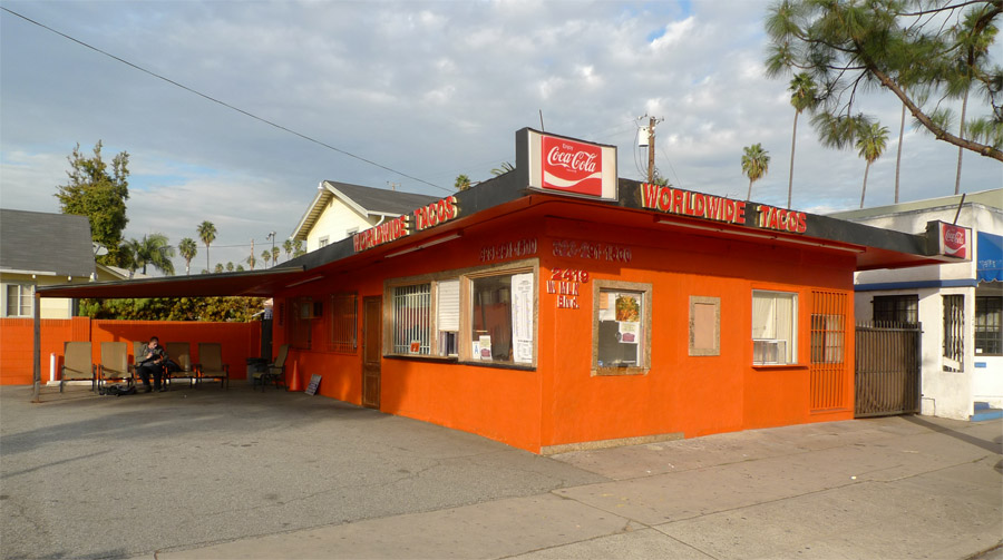
10. Worldwide Tacos
 [Year Unknown]
2419 Martin Luther King Blvd, Leimert Park

The Militant loves tacos, as you may or may know. But along the CicLAvia route is perhaps one of the most unusual taco joints around. Worldwide Tacos makes over 150 types of tacos, in chicken, beef, lamb, chicken, duck, turkey, pastrami, shrimp, fish and vegetarian varieties, all freshly-made and cooked to order. Prices range from $2.50 to $8.50 each. But that's not the catch. The catch is that the wait time ranges from 15 minutes to two hours. The Militant has not tried Worldwide Tacos (nor has he waited for one), but his operatives who have (and endured the long wait, though you can just leave them your cellphone number and they'll call you when they're ready) say they're pretty bomb-diggity. Hmmm...


11. Yellow Car Right Of Way

1902
Leimert Blvd between Martin Luther King Jr Blvd and Vernon Avenue

See that nice, wide, landscaped median branching south of MLK through Leimert Park? Could you ever guess what it used to be? Yup, it was the right-of-way for the Yellow Car trolleys of the Los Angeles Railway, part of  The 5 Line, which ran from Eagle Rock (ya, rly) to Hawthorne. Actually The CicLAvia route from the 110 Freeway to Leimert Avenue was part of the 5 Line, and because of that Leimert Park was originally planned as a transit-oriented community (it was also originally planned as a whites-only community, but so much for that, eh?) Incidentally, part of this same historic Yellow Car Line, along both Crenshaw Blvd and Florence Avenue, will soon be re-used for rail transit as part of Metro's under-construction Crenshaw Line.

12. Baldwin Hills Crenshaw Plaza
1947
3650 Martin Luther King Jr Blvd, Crenshaw District

Originally known as the Broadway-Crenshaw Center, it opened on November 21, 1947 as one of the first auto-centric regional shopping centers in the US. The Streamline Moderne shopping center, designed by Albert B. Gardner, was home to a 5-story Broadway department store, a Vons supermarket and a Woolworth's discount store. In 1949, a Silverwoods clothing store opened, and the landmark bridge over MLK (then known as Santa Barbara Avenue) was built to connect with the existing 1947 May Company building on the north side of the street. Today's version of the shopping center came about during a late 1980s remodel. If you drop by the mall, The Militant highly recommends checking out the cupcakes at Southern Girl Desserts!

13. Sanchez Adobe
1791
3725 Don Felipe Drive, Baldwin Hills

In the streets behind the Baldwin Hills Crenshaw Plaza stands what may or may be the oldest building in Los Angeles. The crown was long believed to belong to the 203 year-old 1818 Avila Adobe on Olvera Street, but further historical research in 2012 revealed that this structure, originally part of Rancho La Cienega o Paso de la Tijera, dates back some 50 years prior to when it was deeded to Don Vicente Sanchez in 1843, making it around 230 years old.  The building was later owned by Baldwin Hills' namesake Elias Jackson "Lucky" Baldwin, who brought freed slaves to work in his homestead after the Civil War. The historic structure - 30 feet wide and two stories tall - has been integrated into a large single-story building built in 1927. It is currently home to Agape Church of Los Angeles.


14. Black Dahlia Body Site
1947
3825 S. Norton Ave, Crenshaw District

On the morning of January 15, 1947, the body of 22 year-old waitress Elizabeth Short, a.k.a. "The Black Dahlia" - the victim of arguably the most famous unsolved murder case in Los Angeles history - was discovered on this site (at the time an empty lot; the house was not built until 1956) by a local woman walking with her young daughter. Short, a transplant from Boston who was reportedly an aspiring actress, was missing the week prior to the discovery of her body, and the case garnered national headlines due to the gory details of her murder. The LAPD's investigation yielded over 150 suspects but no arrests. The cultural intrigue surrounding Short's death became a huge influence on the 1940s 'Los Angeles Noir' phenomenon.

15. Ken Clark Pontiac/Majestic Pontiac Sign
1952
3740 Crenshaw Blvd, Crenshaw District

Although Crenshaw supported a streetcar line south of Vernon, the thoroughfare north of it had always been auto-centric in nature and design. From the late 1930s to 2000, The 'Shaw was once home to an auto row, boasting car dealerships such as Crenshaw Ford, Harry Mann Chevrolet (once the largest Corvette dealer in the US), O'Connor Lincoln-Mercury and Peterson Oldsmobile. The last of the lot, so to speak, was Majestic Pontiac, at Crenshaw and Coliseum. Originally Ken Clark Pontiac from 1952 to 1960, the business was sold and became Majestic Pontiac. The dealership's telltale neon sign with the Pontiac Indian logo was an icon on the boulevard, much like how Felix Chevrolet's cartoon cat smiles over Figueroa today. The dealership closed for good in 2000 and the lot was converted into a shopping center soon afterward. But the original 1952 sign still remains, Pontiac Indian head intact, this time adapted to bear the signage of Big 5 Sporting Goods and Goodwill Industries.
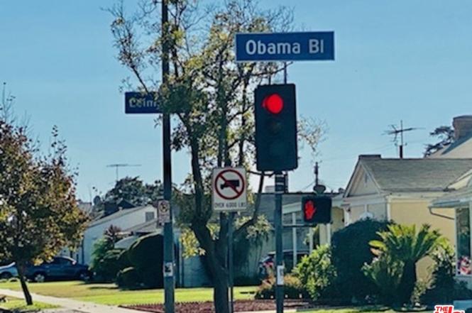
16. Obama Boulevard
2019
Obama Boulevard between Martin Luther King Jr. Blvd and Gramercy Pl

Originally named Rodeo Road in 1911, presumably to honor the history of cattle ranchers of the area, most specifically those of nearby Rancho La Brea. After living in the confusing shadow of the more opulent Rodeo Drive in Beverly Hills since the 1920s, the street was officially re-named and re-dedicated "President Barack Obama Boulevard" in a public ceremony and festival on May 4, 2019, in honor of the 44th (and first African American) president of the United States, who made one of his first presidential campaign appearances at Rancho Cienega Park on February 20, 2007. The street is nestled south of Washington, Adams and Jefferson boulevards, and intersects with Martin Luther King Jr. Blvd. It joins 16 other thoroughfares nationwide named after Obama.


Enjoy CicLAvia again and STAY MILITANT!

Saturday, October 9, 2021

The Militant's Epic CicLAvia Tour XXXVII!!

Interactive map! Click here for larger map.


Hey, we're still alive...it's the second CicLAvia of 2021 and the 37th iteration of Los Angeles' premier open streets event, and we're celebrating one whole decade (plus one year) of these things - the very first CicLAvia was also on a Sunday, October 10 (10 a.m. on 10/10/10).

It's October, which means the DTLA-centric 6-mile "Heart of L.A." route. Just like the last one in Wilmington, this Sunday's CicLAvia is a re-run of a previous route, this time it's the October 2019 and October 2016 alignments. So you may or may not have seen this Epic CicLAvia Tour guide before. But here it is, for consistency's sake.

It's Autumn which means you get to see Los Angeles' fall colors: Blue, purple, gold, etc...The defending World Champion Dodgers are in the midst of a National League Division Series against the hated San Francisco Giants (The series is tied 1-1 and Games 3 and 4 are at The Stadium on Monday and Tuesday), so The Militant expects to see a lot of you CicLAvians in Dodger Blue! The Los Angeles Rams (and, okay, the Chargers too) are playing great football right now, and the 2020 NBA Champion Lakers start their 2021-22 season later this month. Of course, we also got the Clippers, Kings, LAFC, Galaxy, Bruins and Trojans as well, so wear your Los Angeles Fall Colors proudly.

So stay safe, get vaccinated if you haven't yet, and as usual, see you or not see you on the streets on Sunday!


1. Eastside Luv
2006 (Built 1940)
1835 E. 1st St, Boyle Heights

One of The Militant's favorite hangouts in the Eastside, this bar, started by a bunch of friends who grew up in nearby City Terrace, took over the former Metropolitan bar eight years ago and updated it to a more contemporary Eastside-style flavor. Don't call it gentrification, call it gentefication.

2. Mariachi Plaza

1889
1st St and Boyle Ave, Boyle Heights

This is the new town square for Boyle Heights, anchored by the historic 1889 Boyle Hotel on the historic Cummings Block, where Mariachi musicians have been hanging out to get picked up for since the 1930s. The Kiosko, or bandstand, that sits in the plaza is actually not that historic. It was given as a gift from the Mexican state of Jalisco, who literally shipped it over in 1998 where it was assembled in place. But it only gets used once a year for the Santa Cecilia Festival around every November 21. The plaza is also home of the Metro Gold Line station of the same name, which opened in 2009. The unique lending library Libros Schmibros relocated here in 2011. This place could warrant a Militant blog post in itself -- no, an entire week of posts! Don't miss the Farmers Market events there every Friday and Sunday!

3. Simon Gless Farmhouse
1887
131 S. Boyle Ave., Boyle Heights

Back in the totally radical '80s...That's the 1880s, Boyle Heights was an open, rural area and French Basque immigrant Simon Francois Gless built a Queen Anne style house on his sheepherding farm at this location. Today, the house is a City Historic Cultural Monument and is a home that's rented out to -- Mariachi musicians! Just a few blocks west of here is Gless Street, and you might have heard of Simon's great-granddaughter -- actress Sharon Gless, who starred in the series Cagney and Lacey, which aired a century after her arrière-grand-père first settled in Boyle Heights.

4. Keiro Retirement Home/Jewish Home For The Aging
1974/1916
325 S. Boyle Ave, Boyle Heights

With Boyle Heights being a historically Jewish and Japanese community, how's this for an ultimate Boyle Heights institution? This property was originally built in 1916 as the Jewish Home for the Aging (now operating in Reseda), and in 1974, the Keiro Senior Health Care organization, basically their Japanese American counterpart. With the Hollenbeck Palms retirement home just down the street (and site of the John Edward Hollenbeck Estate, remember?) Boyle is a popular corridor for Senior Livin.'

5. Neighborhood Music School
1947 (Built 1890s)
358 S. Boyle Ave, Boyle Heights

The Neighborhood Music School is exactly what it is. But it's also a Boyle Heights institution. Originally founded over 100 years ago when it was located on Mozart Street (orchestral rimshot), the school moved to this Victorian home in 1947 where it still offers music lessons to local youth and the public can drop by on weekends to attend free recital concerts.

6. Metro Division 20 Subway Car Yard & Site of Old Santa Fe LaGrande Station
1992 / 1893
320 S. Santa Fe Ave (visible from the 4th Street Viaduct), Arts District

Take a break from riding/walking/skateboarding/pogo-sticking/etc. and take a glance off the north side of the bridge from the west bank of the River. This facility is where the 104 Italian-built subway cars of the Metro Red and Purple line cars are stored, repaired, serviced and cleaned. This was also the temporary storage and repair site of the Angels Flight railway cars after the fateful 2001 accident. The Militant actually visited this facility back in May 1992.

The subway cars are also serviced on the site of the old Santa Fe Railway La Grande Station (hence the name of the street) that was on Santa Fe and 2nd. Built in 1893, it was precisely where midwestern transplants arrived in Los Angeles after paying their $1 train ticket from Chicago. In 1933, the landmark dome was damaged by the Long Beach Earthquake and subsequently removed. In 1939, it was rendered obsolete by the opening of the new Los Angeles Union Passenger Terminal a few blocks north.

7. Metro 1st St /Central Station Site
2023
1st Street and Central Avenue, Little Tokyo

Prior to 2014, this lot was home to the popular Señor Fish taco joint (formerly the site of '70s-'80s punk venue Atomic Cafe) and Weiland Brewery Restaurant (which opened replacement locations in Echo Park and Uptown Long Beach, respectively). Both buildings were demolished in  to make room for this new Metro subway station for the  Regional Connector project, a new subway under Downtown Los Angeles that will re-align three light rail lines into two and provide continuous, transfer-free service from Azusa to Long Beach and East Los Angeles to Santa Monica. Although Little Tokyo already has a Gold Line station just yards away, that will be demolished and the station replaced with a new underground facility where the current construction activity exists. It's rather fascinating, and it's one way Little Tokyo will more resemble Big Tokyo.  The businesses around the station have been impacted by construction, so make sure you support them, not only during CicLAvia but after!

8. Site of Quaker Dairy, Original Little Tokyo Restaurant
1890
304 E. 1st St., Little Tokyo
On the southeast corner of 1st and San Pedro streets once stood the Quaker Dairy, a restaurant started on this site in 1890 by Sanshichi Akita, an immigrant from Japan. Though preceded five years earlier by another restaurant on First St (location unknown), this is the oldest traceable location of a Little Tokyo business. By the end of the 19th century, there were over 16 Japanese-owned restaurants in this stretch of 1st Street, creating what we know as Little Tokyo.

9. Los Angeles Sister Cities Monument
1987
1st and Main streets, Downtown

On the northeast corner of 1st and Main streets stands a pole bearing signs (in the "Blue Blade" style, no less) for every one of Los Angeles' 25 Sister Cities, each pointing towards their location. The signs range from Lusaka, Zambia (the farthest sister city, 10,017 miles) to Vancouver, Canada (the nearest, 1,081 miles) and everywhere in between. Nagoya, Japan is Los Angeles' oldest sister city (1959); Yerevan, Armenia is the newest (2007). Los Angeles, an Olympic host city (1932, 1984) also has that in common with sister cities Athens (1896, 2004), Berlin (1936), Mexico City (1968) and Vancouver (2010). Okay, the Militant is just filling up this paragraph with mindless trivia.

10. U.S. Federal Courthouse
2016
145 S. Broadway, Downtown
This big glass cube that is responsible for blocking your view of the Downtown Los Angeles skyline from Grand Park used to be a hole in the ground was once the site of the Junipero Serra State Office Building, which was damaged in the 1994 Northridge Earthquake and abandoned and demolished in 1998. This 10-story, 400-foot-tall U.S. Federal Courthouse building (don't we already have a few of those?), designed by Skidmore Owings and Merrill, opened in 2016. Do check out the embossed bald eagle situated over the main entrance on 1st Street.

11. Site of 1910 Los Angeles Times Bombing
1910
Northeast corner of Broadway and 1st Street, Downtown

This longtime empty lot, previously identified in this CicLAvia tour as the foundation of a state office building condemned after the 1971 Sylmar Earthquake has some additional history. It was recently dissevered to be the location of the 1910 bombing of the (then) Los Angeles Times building, which happened 104 years ago this week. The dynamite bombing was discovered to have been the work of Ortie McManigal and brothers John and James McNamara, all affiliated with the Iron Workers Union,  in what was meant to protest the newspaper's staunchly anti-union practices. 21 people died when the 16 sticks of dynamite exploded just outside the building at 1:07 a.m. on October 1, 1910, the explosion was exacerbated by natural gas lines which blew up a large section of the building. The Times since built a new building in its place, and later relocated across 1st Street to its current location. Today, the lot is being readied for an expansion of Grand Park.
NAVIGATIONAL NOTE: 
• If heading north to Chinatown, skip to #21.

12. Bradbury Building
1893
304 S. Broadway, Downtown

A building that's famously meh on the outside, but OMG from the inside, this building has been featured in movies from Chinatown to Blade Runner to 500 Days of Summer. Designed by Sumner Hunt and modified by George Wyman, this 5-story structure was designed to look like the 21st century from 19th century eyes. Despite the ahead-of-its-time design, this building has nothing to do with sci-fi author Ray Bradbury, but was named after developer and 1800s rich dude Lewis Bradbury, who founded his namesake city in the 626.

13. Biddy Mason Park

1991
331 S. Spring St (entrance on Broadway), Downtown

Born as a slave in Georgia over 200 years ago, Bridget "Biddy" Mason was a renaissance woman of her time. Having followed Mormon settlers west, she gained her freedom when California became a slavery-free Union state. As a nurse, she founded the first child care center in Los Angeles and later became a lucrative property owner and philanthropist, having founded the First AME Church, now a major institution in Los Angeles' African American community. She died in 1891 and was buried at ...Evergreen Cemetery (which you might have also seen earlier...see how things all tie together?). A century after her passing, this mini-park in DTLA, on the site of her house, was built and dedicated.

14. Broadway-Spring Arcade Building
1924
541 S. Spring St, Downtown

This unique building is actually three, opened in 1924 on the site of Mercantile Place, a 40-foot street cut between 5th and 6th streets connecting Broadway and Spring. Mercantile Place was a popular shopping and gathering locale in the early 1900s. Having fallen into decay by the 1970s, it was recently renovated and is now famous for, of all things, vendors selling rock band t-shirts. It also becomes an artistic venue during the DTLA ArtWalk. And The Militant probably doesn't need to mention that this building is home to the DTLA Guisado's.

15. St. Vincent Court
1868
St. Vincent Ct and 7th Street, Downtown

You'd hardly knew it was there, but this alley nestled between Broadway and Hill (blink and you'll miss it!), with its decorative brick pavement and European decor, seemingly belongs to another world. Originally the site of a Catholic college that was the predecessor of today's Loyola Marymount University, today it's a unique food court featuring Armenian and Middle Eastern eateries. The Militant calls it, "Littler Armenia." If the place looks familiar, it's also where Taylor Swift frolicked in the rain in the music video of her 2018 song, "Delicate." For more on St. Vincent Court, check out this 2008 Militant Angeleno post for more info!

16. Diamonds Theatre (Warner Theatre & Original Pantages Theatre)
1920
401 W. 7th Street, Downtown
This jewelry retail mart is actually a re-purposed theatre that was the original Pantages Theatre (remember from the last CicLAvia?) opened in 1920 by Greek American entertainment magnate Alexander Pantages for Vaudeville productions. Designed by B. Marcus Priteca (who also designed today's Pantages Theatre in Hollywood), it was sold in 1929 and eventually became the Warner Theatre, screening motion pictures from the WB during the days when the movie studios ran their own theatres. The theatre closed down in 1975 and became a jewelry mart in 1978.

17. The Bloc (Formerly Broadway Plaza/Macy's Plaza)
1973
7th Street between Flower and Hope streets, Downtown

A poster child for change in Downtown, this shopping center, originally built in 1973 and designed by Charles Luckman & Associates as the first suburban-style mall in DTLA combined an indoor (though massively truncated) indoor galleria, a hotel and a 32-story office building. Initially known as Broadway Plaza, named after the old upscale Southern California department store anchor tenant, its name was changed to Macy's Plaza in 1996 after The Broadway merged with the NYC-based equivalent Macy's. Its blocky, street-unfriendly design was derided by many, especially in an era where the outdoor mall format pioneered by Santa Monica's Third Street Promenade, and Rick Caruso's faux-urban monstrosities (and more recently, the newly-opened The Village at Westfield Topanga),  so in 2013 it was re-conceptualized as "The Bloc" and currently stands as a work-in-progress, (which also features a direct entrance to the 7th Street/Metro Center subway station).

18. Wilshire Grand Center
2017
900 Wilshire Blvd, Downtown

On this site rises the new Wilshire Grand Center, Los Angeles' (and the West's -- suck on it, Transbay Tower SF!) tallest building at 73 stories and 1,100 feet (kinda sorta, there's a spire, you see...). Opened in June 2017, it is the city's only modern skyscraper without a flat roof, the only Los Angeles building since Hollywood's Capitol Records tower in 1956 to feature a spire, the first skyscraper anywhere to sport a mohawk, and it also has its own irreverent Twitter account. ;) Owned by Korean Air (hence the red and blue taeguk LED logo), the tower houses the 900-room Hotel Intercontinental with its 70th-floor Sky Lobby and the unique Spire 73 skybar, with wonderful views of the south and west (the sunset vista from here is not to be missed). The building's construction site was the location of "The Big Pour" - which lasted from February 15 -16, 2014, where 21,200 cubic yards (81 million pounds) of concrete for the tower's foundation were continuously poured - earning it a Guinness World Record for that feat. Before the skyscaper, the site was home of the Wilshire Grand Hotel, formerly (in reverse chronological order) the Omni Hotel, Los Angeles Hilton, Statler Hilton and Statler Hotel.

19. City View Lofts/Young's Market Company Building
1924
1610 w. 7th St., Pico-Union

Ever wondered what's the deal with this 4-story Italian Renaissance-style building? It was built in 1924 as a liquor warehouse and original headquarters for Young's Market Company, which still operates today as the largest liquor distributor in the West. This building features actual marble columns and a decorative frieze made of terra cotta. The company, in the roaring, pre-depression 1920s, just felt like it. The building was looted and burned in the 1992 Riots and was rehabbed in 1997 to become the City View lofts. The building is in the National Register of Historic Places.

20. Gen. Douglas MacArthur Monument
1955
Southeast corner of MacArthur Park, Westlake

It's sort of strange how a monument to the park's namesake seems almost invisible (Gen John Pershing, MacArthur's WWI counterpart, could totally identify). In fact, most people don't know it's even there, but on the southeast shore of the lake is a dormant memorial fountain featuring a statue of the WWII general overlooking a model of the Pacific theatre (no, not that one) where he led allied forces to eventual victory. It was designed and built in 1955 by Roger Noble Burnham, who previously sculpted the Tommy Trojan statue on the USC campus and taught at the Otis Art School, formerly located nearby.

• North Spur to Chinatown

21. Site of Court Flight
1904 (demolished 1943)
Broadway between Temple and Hill streets, Downtown

With Angels Flight fiiiiiiiiiinally up and running again (fingers crossed), it's time to pay tribute to the city's other funicular, its cousin to the northeast, Court Flight. Built in 1904, it went up the northern end of Bunker Hill and was next to a former road called Court Street, hence its name. Even shorter than its more famous cousin at 200 feet, it ran steeper at a height of 200 feet. It was burned by a fire in 1943 and never reconstructed. The hill was eventually chipped away. The north side of the stairways going up to the Court of Flags (wonder if that was intentional there) in today's Grand Park is the precise location of ol' Courty.

22. Hall Of Justice

1926
Temple Street and Broadway, Downtown

No, you won't find Superman or any of the Super Friends here.  But this building, the oldest surviving government building in the Los Angeles Civic Center, was built in the mid-1920s as the original Los Angeles County Courthouse and Central Jail (which once housed the likes of Busy Siegel, Sirhan Sirhan and Charles Manson), as well as the headquarters for the Sheriff's Office, the District Attorney and the County Coroner. This Beaux Arts-style building was designed by Allied Architects Association, an all-star team of local architects put together to design publicly-funded buildings. The building is currently undergoing a major renovation project to modernize the facilities and repair damage from the 1994 Northridge Earthquake. It re-opened in 2015 as a LEED Gold Certified building (gotta be sustainable, y'all) with the return of the Sheriff's and District Attorney's offices.

23. Fort Moore Pioneer Memorial
1957
451 N. Hill St, Downtown

Way, way, waaaaay back before we had tall building and freeways, Downtown Los Angeles (well Los Angeles, period back then) had a bunch of hills, Bunker Hill being the most famed one. There was also Fort Hill, the site of a Mexican-American War encampment. On July 4, 1847 the facility was called Fort Moore (and the hill Fort Moore Hill), after Captain Benjamin D. Moore of the U.S. 1st Dragoons regiment, who was killed six months earlier in a battle near San Diego. The 1st Dragoons and the Mormon Batallion established the new fort and raised the U.S. flag during the first-ever observed Independence Day in Los Angeles. This event was immortalized in a bas-relief stone monument made in the 1950s. Speaking of forts, the very street you're riding (or walking, or skating, or scootering, or stand-up-paddling, or pogo-sticking) was once called "Fort Street," which inevitably led to directional problems some six blocks south of here. The monument also includes a fountain, which was shut off in 1977...due to the drought at the time.

So where's the actual hill, you ask? It was bulldozed away in the late 1940s to make room for the 101 Freeway (is this a recurring theme for this CicLAvia or what?!)

24. Chinatown Gateway Monument
2001
Broadway and Cesar E. Chavez. Avenue, Chinatown

Designed to be the symbolic entrance to Los Angeles' Chinatown District, The Chinatown Gateway Monument, a.k.a. the Twin Dragon Towers Gateway, depicts two dragons grabbing at a central pearl, which symbolizes luck, prosperity, and longevity. The 25-foot-tall structure was put up in 2001 and occasionally emanates steam coming from the dragons' mouths. Unlike Anglo dragons, the creatures in Chinese folklore are the good guys, meant to scare away evil spirits.

25. Capitol Milling Co.
1883
1231 N. Spring St, Chinatown

One of the last visible vestiges of Los Angeles' agricultural industry, this family-owned flour mill operated from 1831 to 1997, before moving its operation to a much larger facility in Colton. The facility that still stands today was built in 1883. The mill supplied flour to clients such as Ralphs, Foix French Bakery and La Brea Bakery. In 1999, the family-owned operation was purchased by industry giant Con-Agra Co.
The historic building, built even before the railroads arrived in Los Angeles, still has a horse-tethering ring, back to the days when grain was hauled by horse carriage from farms in the San Fernando Valley. The property is currently being adaptively reused into retail and creative office space.

26. Old (New?) Chinatown Central Plaza
1937
Gin Ling Way between Broadway and Hill, Chintown

The new northern terminus of CicLAvia is no stranger to public events; it was made for them. In the Summer it hosted three very popular Chinatown Summer Nights events. But don't let the "Old Chinatown" neon sign fool you -- This is actually Los Angeles' new Chinatown, which dates back to the 1930s. The real Old Chinatown was several blocks south, where a thriving community of Cantonese-speaking immigrants lived near the river, north of Aliso Street. Of course, they were kicked out in the early '30s to make room for Union Station. So they moved a few blocks north, in the former Little Italy, and they've been there ever since. Well, not really, since some of them moved east to the San Gabriel Valley and were supplemented with Mandarin-speaking immigrants from Taiwan and Mainland China. But you get the idea.

Happy CicLAvia, Los Angeles! Enjoy and STAY MILITANT!

Saturday, August 14, 2021

The Militant's Epic Militant CicLAvia Tour XXXVI!

Click here for larger view!

Hey...it's...been a while. 

The year 2020 initially began with 6 (count 'em) six CicLAvias planned - the most scheduled in a calendar year in the nearly decade-long history of Los Angeles' epic open streets event. 

But then Kobe died. And things weren't quite the same after that.

We did have one CicLAvia in The Most Challenging Year - on February 23, a 5.9-mile jaunt through South Los Angeles from Historic South Central to Watts, a perfect route for Black History Month.

And that was the last time we had a car-free smiling Sunday.

The COVID-19 Pandemic even prevented CicLAvia from having a proper 10th anniversary celebration in October (The Lakers and Dodgers championships kinda made up for that though...kinda).

But here we are, one year, five months and twenty-three days later (539 days for those of you keeping score), with a decent amount of us fully vaccinated (including The Militant himself), it's time to get back together again (though with this Delta thing, we might want to keep our masks on and not get too close (not a problem for The Militant, naturally).

This 2.27-mile zig-zag though the streets of Wilmington is a re-run of the April 28, 2019 route, the shortest CicLAvia route to date, and a truncated version of the "San Pedro Meets Wilmington" route from August 13, 2017.

Speaking of Short and Sweet, this route will only feature 10 points of interest. But these short routes are ideal for taking it easy and chillin', no crowding and keeping SoDis intact, with DMZ's (Dismount Zones) at a minimum.

If all goes well, there are two more this year - the big DTLA-centric "Heart of L.A." route in October to celebrate 11 years of America's Biggest Open Streets Event, and a return to South Los Angeles this December.

The Militant has not missed a CicLAvia since October 10, 2010 and has attended all 35 of them. So he certainly will NOT miss out on Number 36.  As usual, see you or not see you on the streets on Sunday! HAPPY CICLAVIA!

NOTE: When sharing pictures or selfies of any of these locations along your CicLAvia ride on Sunday, don't forget to tag #EpicCicLAviaTour when posting on social media!

1. Wilmington Cemetery
1857
605 East O St, Wilmington

Built on a plot of donated land just north of Banning Park by Mr. Wilmington Himself, Phineas Banning (who was laid to rest here in 1885), this cemetery, one of the oldest in the state of California, is also the final resting place of numerous local Civil War and World War I veterans. It is also designated as a Los Angeles City Historic-Cultural Monument (#414).

2. Phineas Banning Museum
1864
401 East M St, Wilmington

It's appropo that we start our journey (both literally and metaphorically) here. Phineas Banning was one of them 19th century white dudes who basically did something and changed the shape, size and function of the city of Los Angeles forever. Born in Delaware in 1830, he worked as a young man in the shipyards of nearby Philadelphia. He moved to Southern California at the age of 21, but instead of doin' it wagon style cross-country, he took a long-ass boat ride to pre-canal Panama, and took another long-ass boat ride on the Pacific side to this sleepy fishing village called San Pedro, where he worked a number of odd jobs, including driving stagecoaches (it's like being an 1850s Uber driver). The stagecoaches worked between San Pedro and Los Angeles, and after he made some mad bank driving Ube stagecoaches, he launched his own startup - BanningStagecoaches.com. Then he started buying up vacant marshland property near San Pedro and named it after his Delaware hometown of Wilmington. He also was a big visionary type and thought the whole San Pedro-Wilmington are would make a nice port for Los Angeles. Back then, the city was looking at making Santa Monica a port. That big thing he did? He went next level on all them fools and built a railroad from Los Angeles to San Pedro. The City was all like, "Dude, we got a port now." The reason why the City of Los Angeles has a big skinny stick in the bottom is because of Banning. The reason why millions of tons of cargo goes in and out of ships in this area today is because of Banning. The reason why the Ports of Los Angeles and Long Beach are the largest ship terminal complex in the United States is because of Banning. The Greek Renaissance Revival structure in the middle of this 20-acre park in Wilmington was his residence from 1864 to 1885. The City of Los Angeles bought the site in 1927 for historic preservation.

3. William Wrigley's Court of Nations
1927
Lakme Avenue, Banning Boulevard and Cary Avenue between M and L streets, Wilmington

This plot of land south of Banning Park was purchased by chewing gum magnate and Chicago Cubs owner William Wrigley, Jr in 1927 from Phineas Banning (This was not the first time Wrigley dealt with Banning; he also purchased Catalina Island from him in 1919). Wrigley built several residences to house the workers of his local companies, which also included the Wilmington Lines ship ferry company, which transported tourists from the mainland to Avalon. He hired architect Sid Spearin, who designed houses in Spanish, Dutch, American Colonial and Tudor Revival styles and called it "The Court of Nations." The neighborhood became a historic preservation zone in 2001. 
 
4. Avalon Palm Trees

1931
Avalon Bl between Pacific Coast Highway and East I St, Wilmington

Palm trees are everywhere in Los Angeles. Okay, so what? Well, these palm trees had a purpose for being here. Considering the City of Angels will be hosting its third Olympic games in 2028, these 218 Mexican Fan Palm trees are a remnant of an early Olympic legacy. They were planted here along Avalon Boulevard in 1931 as part of a citywide beautification effort for the 1932 Olympic Games. The Sailing competition took place in San Pedro Harbor, just past the southern end of Avalon. Speaking of Avalon Boulevard, did you know that it was originally named Canal Street before 1926? There was once a canal there, which was filled in 1851 and turned into a dirt road.

5. The Don Hotel

1929
906 Avalon Blvd, Wilmington

Opened in July, 1929, The Don Hotel (not to be confused with this guy, but rather its owner, a man named Don Hundredmark) was the most prestigious hotel in Wilmington during the pre-war period. Constructed to cater to tourists going to and from Catalina Island, it became an important gathering place in the area, with luminaries such as William Randolph Hearst and Bing Crosby once staying there. After falling into decay through the 20th century, the building was restored in the 1990s and turned into senior apartments in 1999. The landmark “The Don” neon sign atop the building is a restored sign put up in 2000 that was given the Hollywoodland treatment – it once read, “Don Hotel.”

6. Granada Theater
1926
632 Avalon Blvd, Wilmington

Once Wilmington’s landmark neighborhood Vaudevillian, and later motion picture, theater, it was built with with Renaissance Revival influences and a lighted prominent marquee. The only example of the property type remaining in the area. It was built by C.L. Post (of the Post Cereal family) in 1926 as part of the West Coast Theatres chain. In 1927, Fox Theatres purchased West Coast Theaters and changed the name to the Fox Granada. After falling into decay, it was resurrected (no pun intended) as a church in the 1990s, but was sold in 2015. It is now owned by the nonprofit Wilmington Granada Friends group that hopes to bring it back to its original use as a community entertainment venue.

7. Wilmington Municipal Building
1928
544 N. Avalon Blvd, Wilmington

Originally built in 1928 as the Seaboard Branch of California Bank, this Neoclassical style building has Corinthian columns and pilasters and decorated arches. And that corner clock! More recently, the building, now owned by the City of Los Angeles, is used as the office of the Wilmington Chamber of Commerce. It was also the former field office for Councilwoman Janice Hahn during the 2000s decade.

8. Brick House
1924
109 W. C Street, Wilmington

She's mighty-mighty, just lettin' it all hang out.

9. Wilmington Waterfront Park/Harry Bridges Blvd
2011
Harry Bridges Blvd between Lagoon Ave and Figueroa St, Wilmington

Wilmington Waterfront Park, which opened in 2011, was created a decade ago as a project to provide a 30-acre buffer zone in the form of public open space between the Port of Los Angeles and the residential community in Wilmington. The park features green space/landscaping, paths and walkways, benches, water features, pedestrian bridges, restrooms, drinking fountains, binoculars and a children’s playground. The project also widened Harry Bridges Boulevard.

And who, exactly, is Harry Bridges? He was a 20th century labor leader in the West Coast best known for forming the International Longshore and Warehouse Union (ILWU) in 1937. The union is a huge presence in the blue-collar port communities of Wilmington and San Pedro.

10. The Southernmost End of Figueroa Street

Figueroa Street at Harry Bridges Blvd, San Pedro

This is the extreme southernmost end of the longest street entirely within Los Angeles City Limits (sorry, Sepulveda, you go through so many other cities), Figueroa was named after General Jose Figueroa, the governor of Mexican-Era Alta California from 1833 to 1835. The 25 mile-long thoroughfare runs up through Harbor Gateway and South Los Angeles through Downtown Los Angeles to the extreme opposite end, just north of the 134 Freeway, right below Eagle Rock’s eponymous geological landmark (Yes, that picture is a blue blade style sign taken in Downtown Los Angeles, thanks for paying attention).