Showing posts with label Geography. Show all posts

Friday, March 17, 2023

Peak Knowledge: The Militant's Guide To Our Local Mountain Ranges!


A few weeks ago, while en route to the February 2023 CicLAvia, as The Militant drove up the not-that-congested 405 into the San Fernando Valley, the sight of snowcapped mountains surrounding The 818 made him gasp in a Huell Howsereque, "WHAAAAW!!!" It also reminded him that the various amounts of snow on the mountains emphasized the individual ranges, whereas if he saw the same view on a hot August day, the mountains would all have a uniform brownness to them, as if they were all the same range. But not on that day. The well-frosted San Gabriels loomed in the background, while the lightly-powdered Verdugos stood to the east, and the similarly thin white veil over the Santa Susanas towards the west offered some contrast.

Which got The Militant thinking, "Hey! How 'bout an Epic Militant Post about our local mountain ranges?"

Back during the early days of the COVID-19 Lockdown, in April 2020, The Militant posted this thread regarding that subject on Twitter. But Twitter threads seem rather ephemeral.

It was then he started work on This Here Post, hoping to churn it out in a couple of days, but the task seemed tougher than hiking Mt. Baldy in the winter. But alas, finally, here it is, take it. A few things though:

First of all, The Militant is going to be covering the mountain ranges that can be seen within the Greater Los Angeles Metropolitan Area. This covers everything from The Grapevine in the north to Camp Pendleton in the south, and from Vandenberg in the west to the Coachella Valley in the east. No, we are not going to cover the mountains over San Diego -- you'll have to consult the Militant San Diegan about any of that (Stupid-punk-ass Padres fan that motherf...but anyways...). And as a bonus, the Sierra Nevada Mountains will get covered - we'll talk about that later.

Second, you might ask, "What about the Baldwin/Puente/Chino/Etc. Hills?" The Militant will cover the local hills in a separate, similar post in the not-too-distant future...stay tuned!

Third, you might want to know, "What's the name of that mountain?" The Militant was going to label every one of them. But since there's so many mountains, and to mark them all would be a herculean task in itself (not to mention become very messy, presentation-wise), The Militant will instead share you one of his Militant Secrets: Now, The Militant's primary objective is to inform, educate and enlighten all Angelenos, and not be such a stingy knowledge gatekeeper influencer-type just for the sake of making himself look all bad-ass. So here's one really, really, really awesome resource to learning the names of mountains: peakfinder.org. Just 1) Visit the site; 2) Click on the pin/map icon to the right of the search bar; 3) Move the map until your preferred location is in the circle; 4) Click on the "bird" icon on the lower-right to "fly" to your preferred location; and 5) Scroll left or right to the desired direction to see the mountains you want to view (it will also show you the exact location and time of the sunrise and sunset appropo to your selected locale - cool, huh?). Voila! There's also a Peakfinder app for iOS and Android.

Fourth, a little geology 101 here: There are three kinds of rock classifications (no, not classic, hard and soft):

1. Igneous (borne of fire), like basalt or granite;

2. Sedimentary (comprised of sediments), like sandstone or limestone;

3. Metamorphic (a rock that begins as one of the other types but evolves like a Pokémon due to friction and heat), like the pun-tastic gneiss or schist

The Militant may or may not throw these terms around going forward. He just wants to make sure you know your schist. You will be quizzed at the end of class!

Fifth, The Militant is not a geologist by training or practice, only as a hobby. If you are an actual geologist and find any massive errors in his explanation of geological terms or processes, please let him know! His email: militantangeleno [at] gmail [dot] com.

Oh yeah, you might want the interactive Google map version, so here it is:


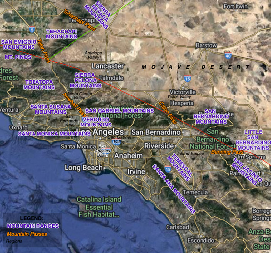
To start with, all y'allz need to know that we got two types of mountain ranges in Southern California: The Transverse Ranges and the Peninsular Ranges. So here we go yo:

Transverse Ranges


The Transverse Ranges are a family of mountain ranges that include the Santa Ynez mountains in Santa Barbara County, the Topatopa and San Emigdio mountains in Ventura County, the Tehachapi mountains in Kern County, the Sierra Pelona, Santa Susana, Santa Monica, Verdugo and San Gabriel mountains in Los Angeles County and the San Bernardino and Little San Bernardino mountains in San Bernardino County.

Whatup with the name? On the North American continent, generally every mountain range runs from north to south: The Sierra Nevadas, the Cascades, the Rockies, the Appalachians. You name it - they mostly all run north-south. But there are only a few places where exceptions exist: Alaska (Brooks Range), eastern Utah (Uinta Mountains), Oklahoma/Arkansas (Wichita and Ouachita mountains) and Southern California. The position of our local mountains greatly influence our climate, our air quality, our watersheds, and our human-built geography. The dozen or so east-west major mountain ranges in SoCal are called the Transverse Ranges, being that they run sideways contra to the usual trending direction of mountain ranges.

So why are they "transverse" like that?

The offshore subduction of an ancient tectonic plate, the movement of the San Andreas Fault and the influence of other major adjoining faults made it happen. Without going into a big-ass geography lesson tangent, let's just say that some 20 or so million years ago, our mountain ranges actually did run north-south (technically northwest to southeast), but good ol' Plate Tectonics actually rotated this little section of the Pacific Plate 110 degrees clockwise!

This video will break it down for ya:


Little San Bernardino Mountains

The Little San Bernardino Mountains, as seen from Highway 62.
Geologically the same as their bigger counterpart, but with radically different flora and climate, are the lower-profile Little San Bernardino Mountains. The easternmost and southernmost of the Transverse Ranges, they are considered part of the desert as opposed to an alpine range on the edge of a desert. Spanning over 40 miles between Morongo Valley in the west and the Salton Sea in the east, they separate the Mojave Desert in the north from the Coachella Valley and the Colorado Desert towards the south and overlook the Palm Springs area from the north. Like their bigger counterpart, they too are greatly influenced by the San Andreas Fault, which runs along their southern side. Their highest peak is Quail Mountain (5,813 feet). The LSBs are home to Joshua Tree National Park and the native environment of the California Fan Palm (Washingtonia filfera). A notable geologic feature is Joshua Tree's eroded granite Skull Rock formation.

Mt. Pinos Formation
Mt. Pinos, as seen from the Wind Wolves Preserve.
Not even a mountain range, yet still part of the Transverse Ranges is the Mt, Pinos Formation. Located in far northeastern Ventura County, just to the west of the I-5, it's the highest peak in the county (8,847 ft) and was once considered part of the San Emigdio Mountains. But further geological research concluded that not only is it separated from the San Emigdios by the San Andreas Fault, but it's made out of igneous granite rock, as opposed to the mostly-metamporphic rock of the San Emigdios. Mt. Pinos is the extreme southern part of what geologists call the Salinian Block, a big-ass piece of granite stretching from Bodega Head in Sonoma County all the way down to here. And the Salinian Block just so happens to rest on the western edge of the San Andreas Fault north of where the fault intersects with the opposite-moving Garlock Fault (the mountain itself is likely the result of the interaction between the two opposing faults). Pinos' shorter neighbor, Frazier Mountain, is part of the same formation. A popular location for hiking, skiing and stargazing, Mt. Pinos is both remote from city lights, yet accessible by The 5.

San Bernardino Mountains

The San Bernardino Mountains, as seen from Beaumont.
Towering over the Inland Empire and located in their eponymous county are the San Bernardino Mountains - the tallest mountain range in Southern California. Spanning some 60 miles from the Cajon Pass near Hesperia to the Morongo Valley, these mountains rise high above the Inland Empire to their south and the Mojave Desert to their north. Like their neighbors the San Gabriels to the west, the San Bernardinos were uplifted by the San Andreas Fault. which runs like a backslash between the two ranges. At one point, millions of years ago, the San Gabriel and San Bernardino mountains were all one mountain range; the San Andreas Fault sliced them into two. Looking at any relief map, the split is obvious. The mountains are the origin of the Mojave River and (most of) the Santa Ana River watersheds. The range's highest point is Mt. San Gorgonio (11,503 feet), which is also the tallest peak in Southern California. Named after the land grant Rancho San Bernardino, the San Berdoos are home to Lake Arrowhead, Big Bear Lake and Silverwood Lake (all artificial reservoirs), Baldwin Lake (natural) and the San Bernardino National Forest. An aquifer in the southern part of the range above the city of San Bernardino bore the mountain spring water which gave a popular regional bottled water company its name. Speaking of which, a notable geologic formation of the San Bernardinos is the natural granitic Arrowhead formation near Arrowhead Springs (then again, it may not be).

San Emigdio Mountains

The San Emigdio Mountains as seen from the southern end of the San Joaquin Valley
near Bakersfield. The white line against the side of Grapevine Peak
is the pipeline segment of the California Aqueduct.

A familiar sight to travelers who pass through the I-5's Grapevine, the San Emigdio Mountains form the southwestern corner of the San Joaquin Valley. As you leave Los Angeles, these mountains would be on your left (the Tehachapi Mountains are on your right) just after you cross the San Andreas Fault and as you descend northbound towards Bako or Frisco. Located within southern Kern County and stretching some 30 miles, the metamorphic and igneous San Emigdios ride just north of the San Andreas Fault and are situated between the Tehachapi Mountains to the east and the non-transverse Temblor Range to the west. Their highest peak is San Emigdio Mountain (7,492 feet). Named after Rancho San Emigdio, which is part of the Grapevine today, the San Emigdios are home to Fort Tejon State Historic Park, the California Aqueduct's Ira J. Chrisman Pumping Plant and Wind Wolves Preserve.

San Gabriel Mountains

The familiar central San Gabriel Mountains, with Mt. Wilson (5,699 feet) on the right.
The highest peak pictured towards center left is San Gabriel Peak (6,162 feet).

Located primarily in Los Angeles County (with the extreme eastern end within San Bernardino County), and stretching 68 miles bookended by the Newhall Pass in Santa Clarita and the Cajon Pass in north San Bernardino, The San Gabriel Mountains are the largest and most important mountain range in the Los Angeles metropolitan area. We may be going ga-ga over the snow cover this time of year, but they really do play a huge role in our daily lives: They help trap the inversion layer, giving us smog, haze and fog. They aid in funneling the notorious Santa Ana Winds in from the east and north. They shield us from the dry heat and monsoon storm humidity of the Mojave Desert (...well, at least most of the time). The sediment that flowed down its creeks and rivers created the alluvial plans that became the fertile farmlands of the San Fernando, San Gabriel and Pomona valleys. Even our leisurely lives are affected by the San Gabes: Our radio and television signals are transmitted from there, and they provide the picture-perfect backdrop every summer evening whenever we attend a Dodger game. Their highest point is Mt. San Antonio, a.k.a. Mt. Baldy (10,064 feet). The mighty San Andreas Fault forms the northern end, and the Sierra Madre (which produced the M6.4 Sylmar Earthquake of 1971) and Cucamonga faults form the southern end that faces us. The mountains are the origin of the San Gabriel River and Santa Clara River watersheds, as well as a secondary contributor to the Santa Ana and Los Angeles river watersheds. Named after Mission San Gabriel, the San Gabes are home to the Mt. Wilson Observatory and broadcast transmitter farm and the Mountain High, Mount Waterman and Mt. Baldy ski areas. Most of the Angeles National Forest is contained within the San Gabriels. Notable geologic formations include Devil's Punchbowl near the Antelope Valley and the pillow-like Mormon Rocks in the Cajon Pass - both located along and formed by the San Andreas Fault.

Santa Monica Mountains

The familiar Santa Monica Mountains overlooking Central Los Angeles.

Bookended by Ventura County's Point Mugu in the west and Los Angeles' Atwater Village neighborhood in the east, the 40 mile-long Santa Monica Mountains are the closest mountain range to many in Los Angeles - and a number of people actually live in them. Colloquially referred to as "The Hill," they form the wall that geographically, geologically and culturally separates the Los Angeles Basin and the San Fernando Valley.  They are also very influential to our local climate - they keep the Pacific Ocean breeze and marine layer within the Los Angeles Basin, which fuels the characteristic hotter and drier climate of The Valley. They are the source of the watersheds for Topanga and Ballona creeks, as well as one of the sources of the Los Angeles River (via Arroyo Calabasas). Formed primarily by the Santa Monica Fault, most of the Santa Monicas are made of sedimentary sandstone, but the far western end is primarily made up of igneous rock of ancient volcanic origin (Conejo Mountain, which overlooks Thousand Oaks, was once an active volcano). The highest peak is the ironically-dubbed Sandstone Peak (3,111 feet), which was actually also formed by volcanic activity. Geologists theorize that because the rock age and composition of the western Santa Monicas matches that of the Santa Ana Mountains down south, they were once the same mountain range some 20 million years ago until tectonic forces rotated most of what is now Southern California 110 degrees clockwise out towards the sea. And the northern Channel Islands - San Miguel, Santa Rosa, Santa Cruz, Santa Barbara and Anacapa - are geologically considered to be an undersea extension of the Santa Monica Mountains. Named after the eponymous coastal city, the Santa Monicas are home to the Hollywood Sign, Hollywood Bowl, Griffith Observatory, Universal Studios, Los Angeles Zoo, The Greek Theatre, The Skirball Center and The Getty (both of them). They were also the domain where P-22 (R.I.P.) once roamed, and where his fellow P-numbered mountain lion relatives currently live. Appropriately, they contain a number of national, state and municipal parks, including Santa Monica Mountains National Recreation Area, Topanga State Park, Malibu Creek State Park and Griffith Park. Two major mountain passes cut through the Santa Monicas - Sepulveda Pass and Cahuenga Pass - both which were originally established as routes by the indigenous Chumash and Tongva peoples and are still used today as streets and freeways. Notable geologic formations include the volcanic Boney Peak in the west end of the range and Griffith Park's Bee Rock sandstone outcropping in the east end.

Santa Susana Mountains

A rare sight of the snowcapped Santa Susana Mountains
overlooking the Valley in late February 2023. Oat Mountain, the range's tallest peak,
is seen on the left.

Stretching for over 30 miles between Saticoy in Ventura County and Santa Clarita in Los Angeles County, and sandwiched between the Santa Clara River Valley in the north and the San Fernando Valley in the south are the Santa Susana Mountains. Separated from the San Gabriel Mountains to the east by the Newhall Pass, the Santa Susanas' highest peak is Oat Mountain (3,747 feet), which overlooks Chatsworth and Northridge. The mountains are secondary contributors to the Santa Clara and Los Angeles river watersheds. Named after the old railroad town of Santa Susanna ("St. Susan"), which is now the city of Simi Valley, the mountains are home to Six Flags Magic Mountain (the thrill capital of the world!), Grimes Canyon, Pico Canyon (site of the first commercially successful oil well in California), the notorious (and particularly gaseous) Aliso Canyon, Big Sky Movie Ranch, Rocky Peak Park (where Boba Fett showed up on 'The Mandalorian') and Michael Antonovich Regional Park. A notable geologic formation in the Santa Susanas is the Chatsworth Formation, a group of sandstone outcroppings (which also contain marine fossils) formed by sand deposits and underwater ocean currents over 65 million years ago, which can be easily seen in the northwestern corner of the San Fernando Valley. It also covers the adjacent Simi Hills to the west.

Santa Ynez Mountains

The Santa Ynez Mountains north of Ventura, as seen from the 101.
The Santa Ynez are to Santa Barbara what the San Gabriels are to Pasadena - You really can't escape them. Located between the Pacific Ocean and the Topatopa Mountains, and primarily within Santa Barbara County, the Santa Ynez Mountains are the westernmost of the Transverses. Both the Santa Ynez and Santa Monica mountains are the only Transverse Ranges that reach the Pacific Ocean. And just like the Santa Monicas, the Santa Ynez Mountains are mostly sedimentary rock, with ancient igneous volcanic rock on their western end. They are created by the uplift of the Santa Ynez Fault. Their highest peak is the unimaginatively-named Peak 4864 (4,864 feet - shocking!), located due north of Santa Barbara but nestled where it can't be seen from that city. Named after Mission Santa Inés (St. Agnes) near Solvang, the Santa Ynez Mountains are home to the Vandenberg Launch Complex (where all those local SpaceX launches originate), Santa Barbara Bowl amphitheater, Santa Barbara Botanic Garden, Gaviota State Park, Knapp's Castle, Cachuma Lake and Lake Casitas. Notable geologic formations are the Chumash Painted Cave - a sandstone cave above Santa Barbara that is adorned with 400+ year-old rock art made by the indigenous Chumash people and the Gaviota Wind Caves.

Sierra Pelona Mountains
The Sierra Pelona Mountains from San Francisquito Canyon, north of Santa Clarita.
Located northwest of the San Gabriels and south of the extreme western edge of the Mojave Desert and Antelope Valley, the Sierra Pelona ("Bald Mountain Range" in Español) Mountains have the San Andreas Fault slicing through their northern edge. They overlook the city of Santa Clarita and the 14 Freeway, both to the range's south. The highest peak is Burnt Peak (5,791 feet). Primarily composed of metamorphic rock, with some sedimentary and igneous zones, Gold was discovered in these mountains in 1842 (six years before that more famous gold rush up north) and was actively mined until the 1890s. The range was also the location of the ill-fated St. Francis Dam (designed by William Mulholland), which collapsed on March 12, 1928. Speaking of Mulholland, the Los Angeles Aqueduct runs through this mountain range via both underground tunnels and siphon pipes, which include two DWP hydroelectric power stations that run off the cascading water from the pipes. The Bouquet Reservoir (St. Francis' replacement) now stores water from the Aqueduct. Meanwhile, Los Angeles' other major water source, the California Aqueduct, has branches that run along the northern base of the mountains (heading towards the Inland Empire) and another through the western part of the range, with a hydroelectric plant and storage facility at Castaic Lake. Notable geologic formations include the it-should-have-a-Hollywood-agent Vasquez Rocks in Agua Dulce (created by San Andreas Fault uplift) and Neenach Volcano, which last erupted 23 million years ago and was sliced in half by the San Andreas: the other half was moved by the fault over time some 200 miles north and now forms Pinnacles National Park in Northern California.

Tehachapi Mountains

Double Mountain (7,981 feet), with wind turbines at its foothills,
looms over the north end of the Antelope Valley.

The northernmost of the Transverse Ranges, the Tehachapi Mountains run some 40 miles between the Tejon Pass in the Grapevine and the Tehachapi Pass in the mountain range's eponymous city. Named after the native Kawaiisu word tihachipia ("difficult climb"), They separate the low-lying farmlands of the San Joaquin Valley to its northwest from the Joshua Tree-dotted Mojave Desert landscape of the Antelope Valley to their southeast. The mountain range is formed by the Garlock Fault, the second-longest tectonic fault in California and unique among faults as a "Left-Lateral Fault," meaning that if you stand in front of the fault line, the land on the other side is moving towards the left (whereas on the San Andreas and most others, the land moves towards the right). This quirk is one of the reasons why the San Andreas has a noticeable bend in Southern California and why the Transverse Ranges exist in the first place. The Tehachapis' highest peak is Double Mountain (7,981 feet), which overlooks the Antelope Valley to the south and the town of Tehachapi to the north. The Tehachapis are home to the Cesar E. Chavez National Monument in Keene, the Tehachapi Pass Wind Turbine Farm and the famous Tehachapi railroad loop.

Topatopa Mountains

The Topatopa Mountains, as seen from the town of Fillmore.
Located mostly within Ventura County (with their extreme eastern end in Los Angeles County), the Topatopa Mountains span over 40 miles between the I-5 on the east and Highway 33 on the west. Named after the Chumash word "topa" which are the rush or reed plants that grow in the wetlands of the area, the mountains are home to the town of Ojai, the Los Padres National Forest, the Sesepe Condor Sanctuary, Lake Piru and Pyramid Lake (both artificially-made reservoirs). The tallest peak in the Topatopas is Cobblestone Mountain (6,738 feet).

Verdugo Mountains

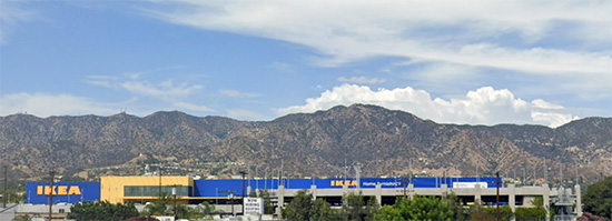
The Ikea Mountai..er...Verdugo Mountains, as seen from Beautiful Downtown Burbank.
The shortest (in length) of the Transverse Ranges, the Verdugos run just 8 miles between Lake View Terrace and Glendale, separating the San Fernando Valley from the Crescenta Valley. Formed by the Verdugo Fault, their highest peak is Verdugo Peak (3,126 feet). Unlike the other mountain ranges, the Verdugos are surrounded by urban development on all sides, making their flora and fauna habitat a virtual island of sorts. Named after Jose Maria Verdugo, the Spanish/Mexican soldier who owned Rancho San Rafael, which encompassed the nearby lowlands, the Verdugos are the home of Glendale's Brand Library, Burbank's The Castaway Restaurant and Starlight Bowl amphitheatre, as well as several parks, including La Tuna Canyon Park, Verdugo Mountain Park and Verdugo Mountains Open Space Preserve.


Peninsular Ranges

Okay, we've covered the Transverse Ranges, but we got normal-type north-south mountains too (well, a few...). Called the Peninsular Ranges (referring to the Baja California Peninsula, in which this mountain cordillera extends all the way down to Cabo San Lucas), they are comprised primarily of igneous granitic rock, which is of the same composition as the Sierra Nevada Mountains to the north. In fact, the Sierra, the Salinian Block (remember that one?) and the Peninsular Ranges (all granitic rock) were once the same mountain range formed by the same geologic process...until the San Andreas Fault came along and done messed things up. Locally, our Peninsular Ranges of concern are the Santa Ana Mountains in Orange, Riverside and northern San Diego counties; and the Temescal and San Jacinto mountains in Riverside County.

San Jacinto Mountains

The snowcapped Mt. San Jacinto towers over the Coachella Valley below
The northernmost of the Peninsular Ranges, the 30 mile-long San Jacinto Mountains are located between the Perris Valley in the west and the Coachella Valley in the east. Surrounded by the 10 Freeway and Highway 74, the range is to the south of the San Bernardino Mountains and to the north of the Santa Rosa Mountains. The mountains form the watershed of the San Jacinto River, which feeds Lake Elsinore. They also contribute to the Santa Ana River watershed and the Whitewater River watershed, which ends up in the Salton Sea. Their highest peak is Mt. San Jacinto (10, 834 feet), and the rest of the range is rather prominent, thanks to the influence of both the San Jacinto Fault (west) and San Andreas Fault (east). Named after the numerous "Rancho San Jacinto" land grants that were located in today's Perris Valley/Hemet Valley area, the range is home to the town of Idyllwild, the Palm Springs Aerial Tramway, Mt. San Jacinto State Park and Soboba Casino Resort. A notable geologic feature is Oswit Rock, a granodiorite outcropping that overlooks the southern end of Palm Springs.

Santa Ana Mountains
The Saddleback of the Santa Ana Mountains (Santiago Peak (R) and Modjeska Peak (C),
as seen from Highway 241 in Irvine.

Overlooking much of Orange County are the Santa Ana Mountains. Situated between (sub)urban Orange County in the west and the Inland Empire in the east, the range runs 61 miles from Santa Ana Canyon down to Camp Pendleton near Oceanside. Much like the Santa Monica Mountains, they trap the cool coastal breezes within OC (windward side) and help make the IE (leeward side) hot AF. The range also contributes to the Santa Ana Winds both in function and in name: The hot desert winds funnel through the mountain range's namesake canyon at their northern edge are the origin of the winds' moniker. Their tallest peak is Santiago Peak (5,689 feet). Together with its shorter neighbor, Modjeska Peak (5,496 feet), they form the Saddleback Ridge, which overlooks Orange County and can be seen from as far as the Santa Monica Mountains. The Santa Ana Mountains form the watersheds for Trabuco and San Juan creeks, both of which flow into the Pacific at Doheny State Beach in Dana Point. Named after the Santa Ana Valley (where Mission Viejo and San Juan Capistrano reside), the mountains are home to Irvine Lake, Santiago Canyon, Modjeska Canyon, Trabuco Canyon and Glen Ivy Hot Springs.

Temescal Mountains
California Golden Poppies decorate the Temescal Mountains near Corona
during the 2019 Superbloom.
These low-lying mountains in the IE, stretching some 21 miles from the Santa Ana River down to the San Jacinto River, with the Temescal Valley to the west and the Perris Valley to the east, are the Temescal Mountains, still comprised of the same granitic rock as its taller Peninsular Range neighbors. Gold and tin were mined here in the 1800s. Formed by the Elsinore Fault Zone, their highest peak is Estelle Mountain, (2,762 feet). Named after Rancho Temescal (which ran down the Temscal Valley into the Oceanside area), they are home to Walker Canyon (a.k.a. the Lake Elsinore Poppyfields), Painted Rock, which features ancient pictographs made by the indigenous Luiseño (Payómkowishum) people, the Lake Matthews reservoir (which is the southern terminus of the California Aqueduct) and Lake Matthews Estelle Mountain Reserve.

The Sierra

Sierra Nevada Mountains

Mt. Tom and the rest of the Sierra Nevada Mountains overlook the town of Bishop.

"Wait," you might say, "This isn't in Southern California!" Geographically, they may not be, but their influence on the Los Angeles area looms as high as they are. Stretching 400 miles from Fredonyer Pass in Lassen County to Tehachapi Pass in Kern County, the Sierra (not "Sierras," BTW) forms California's backbone, literally and figuratively. You may or may not know that some shiny mineral called gold was discovered at Sutter's Mill along the American River (one of the many Sierra Nevada rivers) in 1848. The rest is history. They are also California's icebox, storing the record snowpack from the Great Wet and Snowy California Winter of 2022-2023. Wanna talk watershed? They are the watershed of all watersheds: The snow on top of the mountains will melt into the Kings and San Joaquin Rivers and flow westward into the San Francisco Bay Delta and then south via the California Aqueduct, providing irrigation and livestock water for San Joaquin Valley farms and Central and Southern California municipal water supplies. The snow will also melt eastward into the Owens River and get intercepted by the Los Angeles Aqueduct, heading south through the Owens and Antelope valleys into the City of Los Angeles' municipal water supply (which also gets a good percentage from the CA Aqueduct). Even the city of San Francisco does some Sierra Snowmelt Stealing of their own - from the Hetch Hetchy Valley. That bottle of Crystal Geyser you bought from the liquor store? It originated from snowmelt from Olancha Peak, filters down into an aquifer in the Owens Valley and goes into that bottle. The water that you drink, bathe, swim in, water your plants with, wash your hands for 20 seconds with...a good percentage of it came from the Sierra Nevada Mountains. They're that important, not just to our area, but to every county between Sacramento and Los Angeles. Though not located in geographical Southern California per se, the Sierra Nevada Mountains are still a huge influence on our area, and are part of cultural Southern California: the Mammoth Mountain ski resort (founded by El Segundo native and former LADWP hydrologist Dave McCoy) is a popular skiing destination for SoCal folks (Nor Cal people prefer to head east on I-80 and ski Tahoe), Eastern Sierra towns like Mammoth Lakes and Bishop have Los Angeles Times newsracks, Dodger game broadcasts on the radio and Vons (and not Safeway) supermarkets. Born from magma lifted from deep in the earth some 115 million years ago through the subduction of an ancient tectonic plate into the North American continental plate; the jagged profile of the mountains was carved from glaciers that began over 2 million years ago. You already know that the tallest peak is Mt. Whitney (14,505 feet), but 8 of the 10 tallest peaks in the Golden State reside in the Sierra. Named the "snowy mountains" by Spanish priest Pedro Font in a map he charted in 1777, the Sierra Nevada mountains are home to none other than Yosemite, Sequoia, and King's Canyon national parks, Plumas, Eldorado, Stanislaus, Sierra and Sequoia national forests, the Pacific Crest and John Muir trails, and numerous alpine lakes - most notably the king of all alpine lakes: Lake Tahoe. Notable geologic features include the needs-no-introduction Yosemite Valley, the cinemagenic rounded granite Alabama Hills near the town of Lone Pine and the Palisades Glacier - the southernmost glacier on the North American continent - near the town of Big Pine.

So there you go! A little knowledge on our local ranges. Did you learn something new? Do you feel the mountains calling? Do you have a newfound appreciation for our local peaks? Support The Militant's endeavors via PayPal!

Much Militant thanks to the following who have shown their support over the past few weeks! You are appreciated!

Lily Cosgrove
Michael Gonzalez
Catherine Kay
Lydia Otero
Ramona Monteros
Joe Ryan
Sudeep Sharma
Anthony Swilley, Jr.
Michael Turmon
Kari Wenger
Christina Wilson
Arthur Wong


Wednesday, November 16, 2011

SGV Week: The San Gabriel Valley, Defined

Ever since The Militant first announced San Gabriel Valley Week, more than a few of you asked him to define the San Gabriel Valley's boundaries. Defining regional boundaries is not new for The Militant, as he successfully settled the Eastside/Westside geographical dichotomy by defining Los Angeles' center back in 2008, so he figured he'd take on the SGV.

Now, although The Militant doesn't reveal much about himself, here's what he can reveal from his SGV cred: The Militant has unspecified relatives and family friends from the SGV, and has been visiting those unspecified areas of the valley since the mid-1970s. Some of his best operatives have lived and grew up there. All of the cars the Militant has owned have been purchased from unspecified dealerships in the SGV, and his current automobile was bought at an unspecified dealership in Monrovia (he was smart enough to take the Gold Line and the Metro Local bus there, of course). He also may or may not have maintained employment in the 626 at some point in the past or present. So although he's neither born nor bred there, he feels he has earned considerable Essgeevee cred...(Did he reveal too much there?)

So here 'tis:
[Click on map to enlarge!]
Now, Webster's Dictionary dictionary.com defines a "Valley" as "An elongated depression between uplands, hills, or mountains, especially one following the course of a stream."

So lessee...The San Gabriel Valley is an area surrounded by the San Gabriel Mountains to the north, the San Rafael Hills to the west, the Puente and Brea hills to the south and the 57 Freeway to the east. Interesting how the San Gabriel River/605 Freeway nicely slice the valley in half. The 10 Freeway is the valley's equator. Therefore, the geographic center of the SGV is the 10/605 interchange.

Now...here come the little details: The San Gabriel River and Rio Hondo form an opening known as the Whittier Narrows between the Monterey Hills to the west and the Puente Hills to the east, and encompass other cities that don't perfectly fit the valley bowl (and the 626 area code) such as Montebello and Whittier. But they are undoubtedly linked to the rest of the SGV through the Narrows, so they are part of the SGV. South of Whittier are the Gateway Cities or Mid-Cities which buffer Los Angeles and Orange counties. The Militant considers the southern limit of that part of the SGV as more or less Whittier Boulevard.


The other area of question is towards the northeast of the SGV: Cities such as San Dimas, LaVerne, Pomona and Claremont. Are they SGV or Inland Empire?


The Militant considers them...neither. They are not in the SGV since they are in the 909 area code and not the 626. But they aren't really IE, since they are still Los Angeles County. They are in their own region: The Pomona Valley.

So The Militant's short definition of the SGV goes as such: The entire 626 area code region, plus the geographically-connected cities of Montebello and Whittier. Howzat?!

Monday, September 19, 2011

U Can't Miss This - The Lyrical Map Of Los Angeles (Stop...Hammer Time!)

Last week, The Militant stealthily slipped into Westwood's Hammer Museum to attend a cartographical conversation by Los Angeles In Maps author Glen Creason and artist J. Michael Walker, best known for his All The Saints In The City Of Angels artwork based on saintly city street names.

The artist took his geographical themed creations to another level by creating "City in Mind: a  Lyrical Map of the Concept of Los Angeles" a 23-foot long colored pencil-on-butcher paper illustration of a Los Angeles map highlighted by quotes and drawings of literary and lyrical figures through the ages, centered on various written perspectives of Los Angeles.

Everyone from Fr. Juan Crespi to Raymond Chandler to Joan Didion to Octavio Paz to Charles Bukowski to Jonathan Gold to Tupac Shakur gets quoted here, in a horizontal swath cutting from The Eastside to The Westside, which, incidentally, was direction the City proper expanded.

The illustration, which the artist contends, "still isn't quite finished yet" (there's a good amount of empty real estate and some more quotes to add), involved months of his own literary research, but only took days to draw.

Obviously something like this is MILITANT APPROVED! You must check this thing out! The Militant commands you!

The map is on display until Sunday, October 9 (which is also a CicLAvia Day) as part of the Eastside-based Libros Schmibros' temporary Westwood bookstore, located in the lobby of the Hammer, also until 10/9. There are also a number of interesting lectures that Los Angeles geeks like The Militant and some of you reading this may or may be interested in, so check their site for the full schedule of events. The temporary bookstore is FREE to visit and does not require museum admission.

Will Rogers said it right, even back then.
The Militant hates Westwood traffic with a passion, but fortunately, Metro's Rapid Line 720 stop is right outside the Hammer's front door, so save yourself a headache or two and load up that TAP card!

Tuesday, September 6, 2011

Native Month: Know Your "Na!"


Yesterday's first installment of Native Week gave you a profile of the Real Los Angeles Natives - The Tongva Native American tribe. Today, The Militant will show you where they lived.

We now know Los Angeles (the region) as a bustling metropolis megalopolis of some 15 million people - larger than the population of nations like Ecuador, Guatemala or Cambodia (!) And rightfully so -- this was a nation.

The Tongva was also surrounded by other nations - the Chumash (Ventura and Santa Barbara counties), the Tataviam (North San Fernando Valley and Santa Clarita Valley), the Cahulla (eastern Inland Empire) and the Payomkuishum (North San Diego County).

Take a look at the names and locations of Tongva villages, superimposed over a map of today's Los Angeles (Map updated 9/16/2011):
(Click on map to crumulently embiggen!)
This map was done with much Militant research, but it is no means comprehensive. There were more villages, whose names escaped documented hustory. Some of the locations are generalized and not precise.

Of course, the Tongva nation wasn't nearly as populous - it only had somewhere between 5,000 and 10,000 people.

By looking at the map, you would notice a few things. First, the densities of the villages. Unlike modern Los Angeles, which has its development and poulation centered around Downtown Los Angeles and the area slightly to the west of it, the villages were largely located along the rivers (from west to east on the map: Ballona Creek (which once connected with the Los Angeles River during certain seasons), The Los Angeles River, The San Gabriel River and The Santa Ana River). There were also large swaths of nothingness, mainly because, there were no natural resources (water source, farmable/huntable land) to take advantage of.The Tongva, being a seafaring people, also lived along the coast (Yes indeed, they before anyone else knew the value of beachfront property). There are also a large accumulation of villages (exact locations estimated only) clustered around the San Fernando and San Gabriel areas - of course, those are where the Spanish settlers established the Missions.

Second, though most of these names sound strange and exotic, some of them sound very familiar, and rightfully so -- their present-day names were Hispanicized versions of the original Tongva village name. Places like Cahugna (Cahuenga), Topagna (Topanga), Tuyunga (Tujunga), Azucsagna (Azusa) and Kukamogna (Rancho Cucamonga).

Lastly, most of them end with the letters "-na" or "-gna" (That was too weird sounding for the Spaniards, so they pronounced it "-nga"). That suffix meant, "place." These days, people ask you, "Where you from?" or "Where you stay?" The Militant asks, "Where's your na?"

Can you spot your neighborhood or city on the map?

Here's a list of Tongva villages (their name meanings if known) and their present-day locations (List updated 9/16/2011):

Achois – San Fernando
Ahaugna - North Long Beach, near Los Angeles River
Ahwaagna – Long Beach (Downtown/coast)
Akuuragna - Pasadena-San Marino
Ajaarvongna - Puente Hills
Amupungna - Compton
Apachiagna - Boyle Heights/East Los Angeles
Ashawagna - Chatsworth
Atavsangna - West Hills
Atavayagna - Palos Verdes
Awigna  - La Puente
Alyeupkigna – Santa Anita
Azucsagna (“Place of the grandmother”) – Azusa
Cahugna (“Place of the hill”) – Hollywood/Studio City
Chokishgna – Bellflower
Chowigna – Palos Verdes
Cucamogna – Rancho Cucamonga
Engvangna – Redondo Beach/Torrance
Guaspita – Westchester bluffs (LMU campus)
Hahamongna – Glendale/Pasadena
Homhoangna - Colton
Houtgna – Monterey Park/South San Gabriel
Huachongna - Culver City
Hutukgna - Anaheim
Huutngna - Watts/Willowbrook
Isantkagna - Mission Viejo
Isanthcogna – San Gabriel
Joatngna - Mt. Baldy area
Juyubit – San Gabriel, along the river
Kenyaangna - Newport Beach
Kinkipar - San Clemente Island
Komiikrangna - Malibu Canyon
Kowagna – San Fernando
Kuruvugna – West Los Angeles
Lukupangna – Huntington Beach/Costa Mesa
Masaugna – San Pedro
Maugna – Los Feliz
Momwahomomutngna - San Dimas
Moniikangna - Palos Verdes
Motuucheyngna - Seal Beach
Moyogna – Newport Beach
Muuhungna - Sylmar
Nacaugna – Downey
Okowvinjha – San Fernando
Ongoovangna - Redondo Beach
Ongobehangna - Malibu area
Pahav – Corona (southeast)
Pasbengna - Santa Ana
Pasinogna – Chino Hills
Paxauxa - Norco
Peruksngna - City of Industry
Pimocagna ("Place of the running water") – Pacoima
Pimugna – Santa Catalina Island
Pubugna – Long Beach (Alamitos/CSULB campus)
Puntitavjatngna - Pasadena
Pwingkuipar (“Full of Water”) – Playa Del Rey/Westchester
Quapa - Encino
Saangna – Santa Monica/Venice/Marina Del Rey
Sawayagna – San Fernando
Sehatgna – Whittier Narrows
Sheshiikuanungna - San Marino
Shiishongna - Corona
Shwaagna – Harbor City/Wilmington/Lomita
Sibagna – San Gabriel
Sisitcanogna – Northeast Pasadena
Siutcangna - Sherman Oaks
Sonagna - Downtown Los Angeles
Suangna – Cerritos
Tajauta - Willowbrook
Tibagna - North Long Beach/Lakewood
Toibigna - Pomona
Topagna (“The place above”) – Topanga
Torojoatngna - Claremont
Totongna - Northridge
Tovimongna - Coastal Palos Verdes
Toviseagna – San Gabriel
Tuyugna ("Place of the mountain range") – Tujunga
Wajijangna - Chino Hills
Watsngna - Fontana
Weningna - Covina
Wenot (“River”) – Los Angeles, along the river
Wikangna - Verdugo Hills
Yangna (“Place of the poison oak”) – Downtown Los Angeles

Do you know your Na?

Wednesday, August 31, 2011

A River Ran Through It: In Search Of The Lost Rivers Of UCLA

The Militant Angeleno, as you may or may not know, is fond of retracing the lost waterways of Los Angeles. In April of 2008, he won several awards (okay, he didn't win any, but his blog sure got a lot of hits) on discovering Sacatela Creek, which ran from Los Feliz to Koreatown. A couple months later, he found Arroyo de los Jardines, which runs from Hollywood down to Mid-City, some of it still visible. He thought there weren't any more rivers to retrace...until now.

(Cue dramatic epic theme music...)

School may not be starting up for another few weeks at UCLA, but you're about to get your first Militant History 101 lesson (and you don't even have to be a registered student to learn!).

Whether you're an incoming freshman, a senior about to graduate next Spring, working on your master's or Ph.D, there's a lot you may know, but what you Bruins may not know is what lies under the very ground you walk on.

When UCLA ditched its original campus on Vermont Avenue (now Los Angeles City College) in the late 1920s for a much larger space, originally called the "Beverly Site," it left the bustle of the city for a quiet, serene meadow land near the foothills of Santa Monica Mountains.

The first freshman class at UCLA arrived to a campus of all but five buildings - the landmark Royce Hall being one of them - and a terrain of streams, creeks and arroyos.

Wait, what?

Yes, rivers once ran in Bruin Land. But where did they go?

There were four waterways that ran through the UCLA campus - all north from the Santa Monica Mountains down south eventually towards Ballona Creek - just like the other two rivers that The Militant retraced. There was (from west to east) the West Arroyo, Foothill Stream, Stone Canyon Creek and East Arroyo.


View Lost Rivers of UCLA in a larger map

West Arroyo ran through where the student housing complexes now stand. Foothill Stream ran just west of Drake Stadium.

As for the East Arroyo, it was once the most prominent geological feature of the campus (seen towards the right of the above picture), a sunken ravine that somehow resembled a moat protecting the virtual castles of higher education. In fact, the main entrance to campus was once a bridge that went over the East Arroyo:


And here's what it looks like today (Royce Hall at the left is reference):

The arroyo was filled in in 1947 to make way for Dickson Court and more campus buildings, such as Schoenberg Hall.

So what happened to the bridge? Oh, it's still there. See the low wall running across the middle of the picture above? That's the bridge!


Yes, it's still recognized by the State of California as a functioning bridge, complete with weight limit restrictions (pictured left, ya rly) and periodic seismic inspections.

As for Stone Canyon Creek, it's still very much a creek, starting up in the Santa Monica Mountains, running down parallel to its emponymous road, making its presence in the front yards of more than a few Bel-Air homes.

On the UCLA campus, The Militant is proud to say, the creek still runs - albeit for just a little bit. Found sandwiched between Sunset Boulevard and the Anderson School of Management and hidden behind a layer of trees, lo and behold...you can still see the last vestige of the rivers of UCLA:


For even in the Summertime, the water still flows, just as it always has been, even before the university arrived here. Come see it for yourself sometime!

And then, just like that, the waters unceremoniously enter a storm drain (pictured right), never to reflect light again, at least until it gets dumped into a concrete channel just south of Westwood en route to Ballona Creek.

Fortunately, there are proposals to "daylight" Stone Canyon Creek on the UCLA campus, although it's quite a challenge (funding notwithstanding).  A website makes a call for volunteers to help restore the creek, although it looks like it hasn't been updated since 2007.

Class dismissed. You will be quizzed next week. Professor Militan Tan-Geleno will be available after class in his office for any questions.

In the meantime, The Militant seeks his next lost river adventure!

Militant props to the L.A. Creek Freak and UCLA alum Loteria Chicana for providing a couple leads towards the research of this blog post!
 

Friday, April 9, 2010

Sigh'ns Of Life In Echo, uh Elysian Park

The Militant was driving back to the compound late Tuesday night and spotted these fancy new electronic gateway signs on Sunset Boulevard, that proudly display the community name of "Echo Park." Like similar signs in Downtown, it's meant to relay traffic conditions, road closures, and possibly community announcements or even maybe the occasional Tweet.

Only problem are their locations: One is located on Sunset and Everett St.; the other is located at Sunset and Sutherland St. Doesn't that technically make the signs heralding the entrances to Elysian Park? Looks like some messed up geography there. That's what you get when you have transplants make decisions!

Echo Park, as you may or may not know, is the community just northwest of Downtown Los Angeles that is oft-mistakenly identified as "The Eastside," mostly by the transplanted hipsters that have kind of taken over the place in the past decade. Of course, they do have a lovely eponymous park, which will once again host the Lotus Festival this July.

The Militant saw the signs yet again today on his way to the Stadium to pick up his Opening Day tickets, and was thusly inspired to write this here post. He thought about bringing this up with the local neighborhood council, but the geographical issue is apparently meaningless to them.

The Militant only hopes this is only phase one of the electronic Twitter sign project and that at least two more will pop up further west on Sunset, between Sutherland and a few yards east of Coronado. Otherwise, Epic Geographical Fail!

Monday, March 23, 2009

Contest: Where In The World Is Militant Angeleno? #2

It's been a while wince the Militant did this, no?

Let's sing along again!

Doo wa, de-de-doo-day-ooo-wa
Well he sneaks around the town from Pico to Parthenia
He's an unspecified blogger from Brentwood to Boyle Heights
He'll take you for a ride on his bike in Pasadena
Tell me where in the world is Militant Angeleno?

Steal their Seoul in Koreatown, to an Allesandro alley
From Palms to Magnolia they'll just be all up a tree
He takes the Metro from San Pedro to the San Fernando Valley
Tell me where in the world is Militant Angeleno?

He'll go from Northridge to South Gate, from West Hills to East Los
Compton to Rancho Cucamonga -- and back!

Well he'll mow down your Lawndale and water your Gardena
Then turn on the power of Watts and set a Firestone
From down in Redondo to up in Altadena
Tell me where in the world is Militant Angeleno?

Alright gumshoes, time to find the Militant! Well, he's hard to find actually, but you can at least find out where he's been. The photo above shows part of a mural in an unspecified location in an unspecified part of town. Your job, gumshoes, it to specify it!

The first person to correctly identify the community/neighborhood in the photo above wins a prize!* Email your answer to: militantangeleno at gmail dot com.

Here's a clue: You'll never find a mural like this in the Westside, but it's not in the Eastside either! Though, this wall is facing the west.

Now get to work, gumshoes!

*Only emailed entries will be considered. If you have won a contest from the Militant before, you are not eligible (you know who you are...).

Friday, July 11, 2008

Where In The World...We Has A Winnah!

Militant congrats to reader Joey Terrill of Downtown, who successfully identified the Militant's "location" (for play's sake, not the location of his actual compound) in Tuesday's "Where In The World Is Militant Angeleno?" contest!

The location pictured above is in the community of...(drum roll)...West Adams! The scene pictured is on a little curvy street called Gramercy Park, near the corner of Adams Blvd. and Gramercy Place, just south of the 10 and west of Western Avenue. SOUTH LOS ANGELES REPRESENT!

Other guesses included the Cameron Woods neighborhood of Van Nuys (Deke Babamoto) and Country Club Park (Bert Green). Good gueses, but you oughtta know better! The Militant like totally threw you a curve there! The whole point was to show that the Southside is much more than just "da ghetto."

Joey wins a booklet published the City of Los Angeles entitled Your Government At A Glance, a 40-page primer on City government. It'll fuel Joey's militant knowledge on things like the meaning of the Los Angeles City Seal or the names and functions of all of the city's 42 departments and bureaus!

Congrats again, Joey and thanks for playing, gumshoes!

Doo wa, de-de-doo-day-ooo-wa...

Monday, July 7, 2008

Contest: Where In The World Is Militant Angeleno?

Sing along, will ya?

Doo wa, de-de-doo-day-ooo-wa
Well he sneaks around the town from Pico to Parthenia
He's an unspecified blogger from Brentwood to Boyle Heights
He'll take you for a ride on his bike in Pasadena
Tell me where in the world is Militant Angeleno?

Steal their Seoul in Koreatown, to an Allesandro alley
From Palms to Magnolia they'll just be all up a tree
He takes the Metro from San Pedro to the San Fernando Valley
Tell me where in the world is Militant Angeleno?

He'll go from Northridge to South Gate, from West Hills to East Los
Compton to Rancho Cucamonga -- and back!

Well he'll mow down your Lawndale and water your Gardena
Then turn on the power of Watts and set a Firestone
From down in Redondo to up in Altadena
Tell me where in the world is Militant Angeleno?

Alright gumshoes, time to find the Militant! Well, he's hard to find actually, but you can at least find out where he's been. The photo above shows an unspecified location in an unspecified part of town. Your job, gumshoes, it to specify it!

The first person to correctly identify the community/neighborhood in the photo above wins a prize!* Email your answer to: militantangeleno at gmail dot com.

Here's a clue: It may not be in Central Los Angeles!

Now get to work, gumshoes!

*Only emailed entries will be considered. If you have won a contest from the Militant before, you are not eligible (Sorry, Will Campbell and Robert Joyner, gotta give other people a chance this time...). Residents of IA, MD, SD and AR are not eligible (for no reason really, the Militant just picked those states at random...but then again most readers of the Militant Angeleno most likely do not live there anyway).