Showing posts with label San Gabriel Valley. Show all posts

Friday, March 24, 2023

Places Of The Water!

The sights of spring! The seasonally verdant San Gabriel Mountains overlook a gated subdivision and the San Gabriel River uncharacteristically rushing down below.

Friday, March 24 was a bright and clear day - high winds the night before blew the last remnants of the previous rainstorm away and Angelenos awoke to a sky of blue. Though the Vernal Equinox came and went earlier in the week, today was surely the unofficial official First Day of Spring, if the fully-opened California Golden Poppies on the grounds of The Militant's Compound was an indication.

The Militant headed east by car (he wasn't quite ready for a Metro + bike adventure just yet for an unspecified reason) to the 626. Though the 210 is normally a breeze, it slogged with 405esque slowness for most of the journey from the Rose Bowl onward. The destination: Azusa Canyon! The Militant looked forward to the northernmost reaches of State Route 39 to As Far As He Could Go.

Upon exiting Azusa Avenue, he headed due north, past the Metro station, reminding himself that he hasn't been around These Here Parts since the Gold Line Foothill Extension's grand opening some seven years ago this month. Has it really been that long?

Why Azusa Canyon? Though a light frosting of snow on the upper reaches of the middle San Gabriels (which overlook Pasadena) greeted us down below, the warm, sunny temperatures meant some of that snow was melting already, as well as some of the rainwater that came down during the past few days. The canyon is where the San Gabriel River begins upon its descent down to the San Gabriel Valley and on to its terminus in Seal Beach. After all, Azusa was named after the Tongva village of Asuksagna (later called "Rancho El Susa" by the 19th century Mexicans), which means, "Place of the water." So there you go.

The Militant's plans were slightly dashed when an orange Caltrans road condition sign trailer was set out on Highway 39 bearing the words, "AZUSA CANYON CLOSED." Booo! But The Militant still wanted to see how far he'd go. 

It wasn't long until he saw a set of cones on the road and two CHP vehicles blocking the way. The Militant took a U-turn onto a dirt lot on the side of the road, parked The Militant Mobile and heard the sound of rushing water. The dirt lot was conveniently set on a cliff overlooking the raging San Gabriel River down below. And was it raging. There was water alright, LOTS OF IT.

Not far from where The Militant stood, there was a bicycle/jogging trail that ended in a small cul-de sac. Guess The Militant could have biked up here after all. Noted for next time. After marveling at the sight of blue sky, green mountains and tan-colored rushing water, he made his way back southwards for a bit before crossing the river on a bridge leading to a gated community. But he was able to park on the un-gated street just west of the bridge and walked up to it.

The raging San Gabriel River as seen from the Mountain Laurel Way Bridge.

Though The Militant went as far as he was able to, he didn't want the day to go to waste. He realized that he wasn't too far from Glendora, so he made his way down Azusa Avenue and took a left on Route 66 to get his kicks. In The Militant's Lil'Mil days, Glendora was a familiar place, being where a family friend once lived and owned a business (no longer there). But back then he was not yet attuned to the legendary appeal of the one they call The Donut Man.

The Militant is almost embarrassed to admit that he never partook in the culinary wonder known as The Strawberry Donut, and even though TDM opened a location three years ago that was much, much closer to The Militant Compound, to be initiated into the sacred Strawberry Donuthood rite at a Donut Man location that wasn't the O.G. spot just didn't feel right. So he bought a few of them, as well as their almost-as-legendary Tiger Tail - a delightfully twisted chocolate-with-honey-glaze splendor. The Militant couldn't wait, so he opened the box on the trunk of The Militant Mobile and sank his teeth into the jelly-slathered strawberry wonder sandwiched between two horizontally-cut donut halves. OMG. The hype is real.

Now The Militant has finally earned his right to get one of these at Grand Central Market.

Since he was in Glendora, he might as well check up on the progress of the under-construction Metro L-previously-known-as-Gold-but-soon-to-be-known-as-A-previously-known-as-Blue Line station. He parked next to the Glendora USPS Post Office on Ada Avenue, and there it was, just a few yards up.

The Metro Rail Glendora station. Coming 2025. Or 2026. Or 2027. One of those.

Though the rails were in place, there was little to the station but its concrete foundation and a couple installed-but-non-functioning railroad crossing signals. Seems as though they have a ways to go. But for those of you already making your Foothill Extension Opening Day plans, The Donut Man is a 1 1/4-mile walk to/from the Glendora Metro station (great way to work off those carbs!). Just so you know!

The marquee of the old Azusa Foothill Drive-In Theatre (1961-2001).

Heading back to Azusa, the sight of the Azusa Foothill Drive-In Theatre marquee caught his eye. The drive-in, built in 1961, was, at the turn of the 21st century, the last remaining drive-in theatre along Route 66 west of Oklahoma. It closed in 2001 but the sign was declared a historic monument and was saved. The drive-in location is now the parking lot for APU (no, not that one).

A is for Asuksagna.

The Militant also caught sight of a white letter "A" on a mountainside overlooking The Canyon City. Yes, Azusa has a Hillside Letter (or a Mountain Monogram), a western U.S. phenomenon of placing the initial of a city, town or educational institution on the side of a mountain.

A piece of public art built in 2021 is based around the poem,
"The Stone, The River, The Door," by Krystal Chang.


A tiny cap of snow sits atop Monrovia Peak, as seen from Downtown Azusa.

Housing in Azusa - future and past.

The Union Station-bound L-Line train leaves the Azusa Downtown station with some snow-capped San Gabe peaks in the background.

The Militant wanted to walk around Downtown Azusa for a bit, so he parked off of Azusa Avenue on 6th Street - coincidentally, also in front of a USPS Post Office. He passed a playground that what was once the Azusa Theatre (1926-1972) and a modern mixed-use development a block up the street that features a facade that pays homage to the old theatre. There was also much public art in the form of wall murals, utility box art and a steel public art structure which bore the words of a poem. He went as far as the Metro Station and Target before walking back on the other side of the street. He also happened upon the Azusa  outpost of Congregation Ale House, conveniently just three short blocks from the Metro Rail station. Hmmm...noted.

Heading west on the 210, The Militant exited in Doorty, parked at Encanto Park and visited an old friend he had not seen since September 2015 - the 1907 Puente Largo Bridge, one of the featured surviving Pacific Electric remnants on his Pacific Electric Archaeology Map. It carried the Red Cars between Downtown and Glendora until 1951 and was renovated to its modern purpose as a pedestrian and bicycling path in 1989. The 1,019-foot bridge (the U.S. Bank Tower in Downtown Los Angeles could rest on the bridge end-to-end in its entirety with a foot to spare each side) spans the normally dry banks of the San Gabriel River - but not this day! The river was rollin' and raging! He was just a few miles south of where he was previously, and this water was well on its way to the spreading grounds in nearby Irwindale, where it will enter the groundwater table to be later used by the MWD and some of the local municipal water utilities.

The Puente Largo Bridge in Duarte. Not bad for a 116 year-old.

The riverbed was so much greener than when he was last there - the banks of the river also had small basins that caught excess flow from culverts. The basins also functioned as vernal pools, with wild (though invasive) mustard flowers popping up nearly everywhere. There was also a bike bath along the east bank of the river that reminded The Militant that he should take on this river path via two wheels sometime.

Vernal pools past the east bank of the San Gabriel River, with the bike path to the left.

The Militant continued on westward on the 210, but he wanted more. While searching for a place to eat, he saw a sign along Altadena Drive that read, "Eaton Canyon Natural Area Park." Hmmm. So he followed the signs up the road, past New York Avenue and entered an area right at the foothills with bushes and wildflowers galore. As soon as he got out of his car, he heard it: The sound of rushing water.

Eaton Wash is alive!
The Militant got so excited, he climbed down into the creek bed, crouched down and scooped up a handful of cold, clear water that made its way down the San Gabriels. It was this hardcore city boy's little moment with nature and it was quite awesome.

Wild Bush Sunflowers were in bloom.
Back on the trail, he was surrounded by rows and rows of native Bush Sunflowers in bloom. There were some prickly pear cacti in the area. A couple that was hiking asked him where the waterfall was. Though unfamiliar with the trail, he knew that it went in a roughly straight-line direction northward, so he pointed to the mountains. But he was curious about it now that the topic came up. So he kept walking towards the San Gabes. Several yards ahead, the trail dipped down in elevation slightly and the sound of rushing water grew louder. He saw another couple (one of them carrying a baby) walking across the shallow, yet fast-moving Eaton Wash, the water whitened as rapids by nearby large rocks. He didn't think crossing the water was a smart idea, but he watched vigilantly and at the ready while The Adventure Family was reaching the other bank, just in case there was a potential emergency. Fortunately, Adventure Family made it across safely, but The Militant didn't want to get his boots soaked, so he just stayed on the south bank, taking pictures and video.

Heading back, he stopped by the little Nature Center that had a small exhibit on the water table in the area. Eaton Canyon's watershed is part of what is called The Raymond Water Table, by which the cities of Pasadena, Altadena and other nearby municipalities pump for use in their respective water supplies. So no, this water doesn't go wasted out to sea. It is part of the greater Los Angeles River watershed, as it flows into the Rio Hondo, which meets the Los Angeles River in the South Gate area. There was also a cool California native plant garden outside of the Nature Center building.

The Militant headed out and back to Altadena Drive, being in awe that the Eaton Wash's rapids were just a few hundred yards from the streets of Pasadena. He proceeded south on Altadena Drive and west on Washington Street and found a place called Baja Cali Fish & Tacos.

Baja Cali's #3 combo with two Baja Cali Tacos, fries and drink for $11.99
The tacos had grilled fish and shrimp. Nothing mind-blowing, but it was pretty good. The restaurant seems to be a local chain with locations in the San Gabriel Valley, as well as in Long Beach and Highland Park. He'd definitely try out the other items next time (the potato and birria taco selections sound appealing).

He made his way back to the Militant Compound as the sun was setting on the first clear evening in a long-ass time. Here's to spring, here's to watersheds and wildflowers!


Thursday, April 19, 2018

The Militant's Epic Militant CicLAvia Tour XXV!!!

To see larger map view, click here.

Here we go, folks, CicLAvia season has officially begun! There are uh...[an unspecified number of] CicLAvia open streets events in this here year of 2018. The first one of the year takes us allllllll the way to the farthest eastern reaches of Los Angeles County, like almost even San Bernardino County here, for the "Heart of the Foothills" route.

Okay, The Militant is going to step on his soapbox here for a second: WHY IS THERE A CICLAVIA ALL THE WAY OUT IN FAR, FAR, FAR, FAR EASTERN SGV?!?! CicLAvia is supposed to take place within the City of Los Angeles or in neighboring cities (Pasadena - you cool). It's also sponsored by Metro, who's ponying up a lot of dough to put on an even that's NOT EVEN IN ITS SERVICE AREA. Also, the SGV has their own regionally-branded event, 626 Golden Streets. SO WHY IS THIS A CICLAVIA?!?! Especially when the City of San Fernando, which is 1) A neighboring city to the City of Los Angeles; 2) Well within Metro's service area (shout-outs to Metro Local Line 94) BUT THEY HAD A NON-CICLAVIA-BRANDED OPEN STREETS EVENT IN MARCH.

What next, CicLAvia Las Vegas Strip Meets Downtown Vegas?

Pardon The Militant, it's just that he NEVER misses a CicLAvia, and this time he has to either  take a one-hour Metrolink ride or drive all the way out to the route early Sunday morning (or even spend the night in a nearby hotel...). It seems as though this whole event was a total oversight, or there's some sort of shady activity going on, or...who knows what. The Militant has voiced this on Twitter and the normally-responsive CicLAvia account has been tight-lipped about staging a CicLAvia out there in BFE-adjacent. C'mon CicLAvia organizers...don't forget what the 4th and 5th letters of your name stand for.

Alright, take a deeeeep breath, Militant.

[inhales....exhales]

Okay, rant is over. The reality is that there's a CicLAvia, and The Militant has to travel a long-ass distance to get to it. FINE.

So here's your stinkin' Epic CicLAvia Tour...for the 25th time.

It's 6.7 miles from Claremont to San Dimas, via Pomona and La Verne (not Shirley). Lots of history yadda yadda yadda. Lots of old train stations, former railroad hotels and institutions of higher learning. That's basically it.

1. Marston Quadrangle
1923
College Ave & 4th St, Claremont

This open green space at the heart of Pomona College's campus not only marks the original site of the college (which started out here in 1887 in a former railroad hotel building), but in 1923 the Quad became the central commons area for the expanded campus, fashioned after the one at the University of Virginia (founded by some dude named Thomas Jefferson). The Quad was envisioned by the college's first president as a "college in a garden" borrowing aesthetic elements of East Coast Ivy League schools, but set in the Mediterranean climate setting of Southern California. The Quad was named after George White Marston, a San Diego-based philanthropist who was the first president of Pomona College's Board of Trustees. The Quad continues to be used as a public open space for recreation and formal events.


2. Claremont Depot & Pacific Electric Right of Way
1927
1st Street & College Ave, Claremont
Claremont might be known as a college town, but it started out as a railroad town. In 1887, it was founded by the Atchison, Topeka and Santa Fe Railway who built a wooden Gothic train depot on this site and named it "Claremont," because they felt like it. Forty years later, the station was replaced by a Spanish Colonial Revival building designed by company architect William H. Mohr (who also designed the station's older sister and familiar sight to Gold Line riders, the 1916 Monrovia Depot, as well as the 1918 San Bernardino Depot). Trains that originated in places as far as Chicago stopped at this station until 1967 when the station closed for business. The city of Claremont, recognizing its historic importance (it was placed on the National Register of Historic Places in 1982), purchased the building in 1989, and in 1993, it saw new life again as a train station, this time serving Metrolink commuters between Los Angeles and San Bernardino. A packing house a few doors to the west also served Santa Fe freight trains, shipping local citrus fruit to points east.
This location not only served Santa Fe trains, but Pacific Electric Red Cars as well. First Street, where the CicLAvia route runs, once had the Pacific Electric Right of Way running in its median. The photo above, taken by Jack Finn, shows the intersection of 1st St and College Ave (looking east) exactly 70 years ago!  The building on the right was the Pacific Electric's own train depot, which was unfortunately demolished in the 1960s. In addition to having train stations past and present, this location will also have a future rail stop in the form of a Metro light rail station as part of Phase 2 of the Metro Foothill Extension, opening by 2026.


3. Adobe de Palomares
1854
491 Arrow Hwy, Pomona

If you know your local history, you'll know that before the 1850s, Southern California was part of Mexico and the land was divided into large areas known as ranchos, granted by Alta California's governor to various aristocrats and prominent military figures, to use for cattle grazing, farming and homesteading. Ygnacio Palomares was one of these dudes, who in 1837, was co-granted Rancho San Jose (today all four of today's CicLAvia cities, as well as Azusa, Covina, Diamond Bar, Glendora and Walnut). Señor Palomares built his first adobe a few miles south in Pomona,  and in 1854 built a new single-story, 13-room, 20-acre hizzouse right here in north Pomona. It was a popular overnight stopover point between San Bernardino and Los Angeles (remember, no freeways or even paved streets back then). It was abandoned in the 1880s and restored in the 1930s, later purchased by the city of Pomona. In 1940, the adobe became a museum, and the city even allowed Palomares descendants to live in the adobe as caretakers. The last family member lived there until 1958. It is considered one of the most complete extant examples of Mexican rancho-era Southern California adobes. Check it out!

4. Pomona Depot
1941
Garey Ave & Santa Fe St, Pomona

Adjacent to today's Pomona North Metrolink station is the original Santa Fe Railway depot serving Pomona. Built in 1941, it is much newer than (and not as architecturally ornate as) its sister stations down the line, but it served legendary Santa Fe trains like the El Capitan from Chicago to Los Angeles via Pasadena until 1967. It served Amtrak trains until 1996 when the Northridge Earthquake damaged several bridges enough to re-route the line through Orange County. In 1992 the modern-day Metrolink station opened several yards west, and this building was converted into a Metrolink operations center.


5. Metro Gold Line La Verne Station
2026
E. St & Arrow Hwy, La Verne
There's nothing here yet, but the empty space on the northeast corner of E St. and Arrow Hwy will become the La Verne station for Metro's Phase 2 Foothill Extension light rail line. Not only will it serve the nearby University of La Verne campus, but it is pretty dang close to the Los Angeles County Fairgrounds, just over a mile southeast of the station. When the line opens by 2026, expect shuttle buses to take riders to the Pomona Fairplex every September. 

6. Church of the Brethren
1889/1929
2425 E St, La Verne

This church has played a huge role in the ity of La Verne. Originally known as "Lordsburg" after real estate developer Isaac Lord, who got the Santa Fe Railway to build a station on his property, the region attracted tourists and later transplants from the midwest due to a fare war between the railroads and the rapid popularity of Southern California due to its weather and agriculture. In 1889, a man named M.M. Eschelman, a member of the Church of the Bretheren (a German-based Christian denomination with a pacifist theology akin to that of the Quakers and Menonites), was responsible for establishing a Brethren-affiliated college that would eventually be known as University of La Verne. The current church building was designed by architect Robert H. Orr and built in 1929.

7. University of La Verne
1891
1950 3rd St, La Verne

Church of the Brethren member M.M. Eschelman arrived in town (then known as Lordsburg) in 1889. He sought to establish a church-affiliated college, after starting one such school in Kansas. He convinced town founder Isaac Lord to sell his unsuccessful railroad hotel to Eschelman, and Lordsburg Academy was established in 1891. The town's population grew, with many residents being church members. After Mr. Lord died in 1917, the town was re-named La Verne, a French phrase meaning "Spring-like" or "growing green." It was coined by local ranchers who described the foothills as such. With that, Lordsburg Academy became La Verne College, and University of La Verne in 1977. The university is now officially non-sectarian, but maintains traditional and organizational ties to its founding church.


8. Kuns Park/Kuns House
1939/1911
1600 Bonita Ave/2449 Magnolia Ave, La Verne

This 2.5 acre green space is the oldest park in La Verne. Built as part of the original Lordsburg tract, it was once part of an 18-acre ranch owned by Henry L. Kuns, the son of David Kuns, one of the four founders of Lordsburg Academy (now University of La Verne). In 1911, the younger Kuns, then the mayor of Lordsburg, had his  7-bedroom Edwardian Tudor/Craftsman  Bungalow house built on the property. Kuns himself planted the carob tree at the northeast corner of the park. He died in 1930 and his heirs refused to pay the property tax, so the park was bought by the city in 1938 at an auction for $200. The green space later became an official city park. The house was passed on from family members to other owners, and went on the market in 2012 following the death of its owner at the time. The University of La Verne eventually purchased the house to function as the university president's residence, bringing the house's connection to the academic institution full circle.

9. San Dimas Circle K
301 E. Bonita Ave, San Dimas

(DISCLAIMER: This was not the actual Circle K store depicted in the 1989 motion picture, "Bill and Ted's Excellent Adventure." That one was filmed in Tempe, AZ. [BOGUS!])


Despite the above disclaimer, if you choose to get a CicLAvia selfie/group selfie here, you may or may not encounter a couple of excellent local dudes there who have encountered a bodacious time travel experience. You also may or may not encounter a dude named Rufus who is known to appear in the parking lot in a telephone booth (If you're under 30, you'll have to Google that). Also, do not be alarmed if you see yourself come out of that telephone booth, explaining you you that they're you and have come from the future. After all, The Militant has heard that strange things are afoot at the Circle K.

And if not, there's always the hot dogs.


10. Jedediah Strong Smith Statue
1992
245 E. Bonita Ave, San Dimas

In front of San Dimas City Hall stands a bronze statue of some dude taking a knee, although it doesn't look he's engaged in prayer or protest. It's actually a public art monument created by sculptor Victor Issa in 1992 entitled, "A Welcome Sight." The dude is a man named Jedediah Strong Smith, a 19th-century explorer who was the first person to lead a party of Americans by land into California (then part of Mexico) in 1826. His group left Great Salt Lake in August of that year, crossed the deserts, and according to his journal, reached the crest of the San Gabriel Mountains by November and looked down at the valley below. His pose and the sculpture's title were meant to reflect his expression as he looked down into what would be known as The 626. His connection to San Dimas was that his party camped in an area filled with mud springs on November 26, 1826 en route to Mission San Gabriel. San Dimas' former name was La Cienega Mud Springs.  If the dude's name sounds familiar, he is the inspiration behind the folkloric character Jebediah Springfield on "The Simpsons." Interestingly, Jebediah Springfield's town square statue also depicts him also standing on one knee. Wait a minute...Mud Springs...Springfi...OMG NO WAY!


11. Metro Gold Line San Dimas Station
2026
San Dimas Ave & Railway St, San Dimas

The Phase 2 of the Metro Gold Line's Foothill Extension, which broke ground in December 2017, will stop at this location just south of downtown San Dimas by 2026, en route to its eventual terminus in Montclair. Of course, by then the line will no longer be called the Gold Line, but the Blue Line (or the A Line), which, thanks to the Regional Connector, will merge the current light rail lines to Long Beach and Azusa into one long-ass one.

12. The Walker House
1887
121 N. San Dimas Ave, San Dimas


Known as the most historically significant building in San Dimas, this Queen Anne structure, designed by the Newsom Brothers, was originally built in 1887 to be a local railroad hotel (the second building built in town) until Kentucky transplants James and Sue Walker purchased it for their family residence in 1889. Multiple generations of the family lived in the house until the 1970s. In 1972, it made the National Register of Historic Places, functioned as a restaurant at one time, and in 2000 it was purchased by the Redevelopment Agency of the City of San Dimas, who performed a major restoration on the house completed in 2009. Today it is home to the San Dimas Historical Society, the San Dimas Festival of Arts and the Lucabella restaurant.

13. Pacific Railroad Museum/San Dimas Santa Fe Depot
1934
210 W. Bonita Ave, San Dimas

By now, you've pretty much got the hang of it: The Atchison, Topeka and Santa Fay Railway built a railroad from Chicago to Los Angeles and en route ran the tracks through here in 1887 and pretty much established most of the cities we see today. The existing historic train station was built in 1934 to replace the original wooden depot. The last train served it in 1967 and was re-purposed as the offices of the San Dimas Chamber of Commerce and later a senior center. In 1994, the nonprofit Pacific Railroad Society purchased the depot and made it into a railroad museum, which also has a stretch of the original track that Santa Fe laid here in 1887. The Militant visited the museum (and Downtown San Dimas) in 2009.

Happy CicLAvia on Sunday! As always, see you or not see you on the streets!

Friday, December 30, 2011

A Balian Points Of Light


For those of you still trying to get your Holiday Spirit on, get on up to Altadena. It's not only home to the famous Christmas Tree Lane on Santa Rosa Avenue, but it's also home of one of the biggest light displays in town.

The famous Balian mansion on Mendocino Lane near Allen Avenue, has been lighting up their house every Christmastime since 1955. The Armenian American family built an empire out of selling ice cream in 1949 and today is the largest supplier of ice cream to the LAUSD and other school districts (those of you who went to LAUSD schools know what's up).

The Militant would have linked to their website in the above paragraph, but...they don't have one.

The Militant checked it out recently and was floored. Yeah, it's bright, but surprisingly not as tacky as you'd think (seriously, there have been some real awful ones around town). It's also an equal-opportunity Christmas display, with religious figures of The Nativity, Three Wise Men and angels on one side, and secular wintery figures of Santa Claus, snowmen and sleighs on the other. Naturally, it's a tourist attraction - The Militant counted about two dozen people, mostly families, posing for pictures or taking videos.

It's relatively easy to get to - just take Allen Avenue north, keep going, keep going, keep going...after you pass New York Drive and the school on the right side, make a right on Mendocino. YOU CAN'T MISS IT, LOL. It's also transit-accesible - take the (M) Gold Line to the Sierra Madre Villa Station, and take Metro Local 264 (why you can't take a single bus from the Allen Station (the 686 stops there, but only takes you to New York Dr.)...that's Metro Logic). You can ride your bike, of course, from the Allen Station.

A Nativity scene with the Three Wise Men...

...and just a couple yards away, another set of Three Wise Men. That's gonna be awkward when they arrive.
Jolly Old St. Nick appears to be setting a brush fire!

Families pose for pictures at Altadena's biggest tourist attraction.

Wednesday, November 16, 2011

SGV Week: The San Gabriel Valley, Defined

Ever since The Militant first announced San Gabriel Valley Week, more than a few of you asked him to define the San Gabriel Valley's boundaries. Defining regional boundaries is not new for The Militant, as he successfully settled the Eastside/Westside geographical dichotomy by defining Los Angeles' center back in 2008, so he figured he'd take on the SGV.

Now, although The Militant doesn't reveal much about himself, here's what he can reveal from his SGV cred: The Militant has unspecified relatives and family friends from the SGV, and has been visiting those unspecified areas of the valley since the mid-1970s. Some of his best operatives have lived and grew up there. All of the cars the Militant has owned have been purchased from unspecified dealerships in the SGV, and his current automobile was bought at an unspecified dealership in Monrovia (he was smart enough to take the Gold Line and the Metro Local bus there, of course). He also may or may not have maintained employment in the 626 at some point in the past or present. So although he's neither born nor bred there, he feels he has earned considerable Essgeevee cred...(Did he reveal too much there?)

So here 'tis:
[Click on map to enlarge!]
Now, Webster's Dictionary dictionary.com defines a "Valley" as "An elongated depression between uplands, hills, or mountains, especially one following the course of a stream."

So lessee...The San Gabriel Valley is an area surrounded by the San Gabriel Mountains to the north, the San Rafael Hills to the west, the Puente and Brea hills to the south and the 57 Freeway to the east. Interesting how the San Gabriel River/605 Freeway nicely slice the valley in half. The 10 Freeway is the valley's equator. Therefore, the geographic center of the SGV is the 10/605 interchange.

Now...here come the little details: The San Gabriel River and Rio Hondo form an opening known as the Whittier Narrows between the Monterey Hills to the west and the Puente Hills to the east, and encompass other cities that don't perfectly fit the valley bowl (and the 626 area code) such as Montebello and Whittier. But they are undoubtedly linked to the rest of the SGV through the Narrows, so they are part of the SGV. South of Whittier are the Gateway Cities or Mid-Cities which buffer Los Angeles and Orange counties. The Militant considers the southern limit of that part of the SGV as more or less Whittier Boulevard.


The other area of question is towards the northeast of the SGV: Cities such as San Dimas, LaVerne, Pomona and Claremont. Are they SGV or Inland Empire?


The Militant considers them...neither. They are not in the SGV since they are in the 909 area code and not the 626. But they aren't really IE, since they are still Los Angeles County. They are in their own region: The Pomona Valley.

So The Militant's short definition of the SGV goes as such: The entire 626 area code region, plus the geographically-connected cities of Montebello and Whittier. Howzat?!

Tuesday, November 15, 2011

SGV Week: Made In The San Gabriel Valley


Hot and sprawling, you wouldn't think anything of any value could come from a place like the San Gabriel Valley, but think again, it's actually given birth to many people and things, some of which you'd never guess originated here.

For instance, the whole concept of college football "bowl" games started on New Year's Day 1902 in Pasadena with the inaugural "Tournament East-West Football Game" -- eventually renamed "The Rose Bowl" 21 years later. And erryone else be bitin' afta dat.

Speaking of bites, being heavily influenced by Route 66, the postwar car culture and associated suburbanism, a number of well-known food chains were born here in the SGV. By far the most famous is Baldwin Park's In-N-Out Burger, established in 1948. Also started that year was a Temple City donut shop owned by Verne Winchell -- Winchell's Donut House. Supermarket entrepreneur Joe Coulombe started the first Trader Joe's market on Arroyo Parkway in Pasadena in 1967, and on the other side of town six years later, Chinese immigrants Andrew Cheng, his wife Peggy and his father Ming Tsai opened Panda Inn on Foothill Blvd, spawning the Panda Express chain.

But perhaps the biggest contribution the SGV gave to the food world was the cheeseburger. Yes, the food that LOLcats everywhere crave was invented in Pasadena by 16-year old cook Lionel Sternberger who worked at his father's now-defunct restaurant The Rite Spot on 1500 W. Colorado in the mid 1920s and "experimentally dropped a slab of American cheese on a sizzling hamburger."

A couple legendary toys were introduced to the world in the SGV -- in the 1950s, the then-San Gabriel-based Wham-O Manufacturing Company gave us the frisbee and the hula hoop (Though both had origins from other times and places, the plastic toy versions we know and love were 100% SGV product).

Even everyone's most beloved little green slab of clay, Gumby, is an SGV native. He was created in the early 1950s by recent USC film school grad Art Clokey and his wife Ruth in their Covina home. GUMBY!!! GUMBY, DAMNIT!!!

Other famous San Gabriel Valley natives inclue World War II General George S. Patton (San Gabriel), former New Mexico governor and presidential candidate Bill Richardson (Pasadena) and cooking legend Julia Child (Pasadena).

The SGV's biggest contribution to music is Pasadena's own Van Halen (none of its members were SGV natives, but the band itself originated here), formed in 1972 as "Mammoth" and renamed to VH two years later. The Black Eyed Peas' singer Fergie (Hacienda Heights), the late scatting '90s Euro-house singer Scatman John (El Monte) and "Toy Soldiers" singer Martika (Whittier) also all hail from the SGV.

Remember this guy? Straight Outta Whittier.
Two major Oscar-winning actors were also born in the San Gabriel Valley: Sally Field (Pasadena) and Tim Robbins (West Covina).

A number of TV child stars also came from the SGV: Punky Brewster's Soleil Moon Frye (Glendora), Family Ties' Tina Yothers (Whittier) and even Steve Urkel himself, Jaleel White (Pasadena).

Being full of recreation areas, the SGV also spawned a number of professional athletes -- most notably former UCLA Bruins and Dallas Cowboys quarterback Troy Aikman (West Covina), former Yankees and A's (and current Rockies) slugger Jason Giambi (West Covina) and Phillies second baseman Chase Utley (Pasadena). but the SGV-born athlete The Militant is most partial to is none other than former Dodger Nomar Garciaparra (Whittier). Oh yeah, he played on some Boston team too.

Yes, great things can and do emerge from that vast flatland surrounded by the San Gabriel Mountains, and the San Rafael, Monterey, Puente, Brea and Pomona hills. SGV, you definitely can has cheezburger.

Monday, November 14, 2011

SGV Week: The Militant Is On A Mission

The Militant wanted to start off San Gabriel Valley Week with a post on the eastern glen's namesake and cradle of civili...er...Western civilization - Mission San Gabriel Arcángel, located in its eponymous city.

It was founded on September 8, 1771 - a full decade before the City of Los Angeles was founded.

But what most people aren't aware of, is that the stately mission, which has withstood centuries of earthquakes, and has flown under the flags of four nations, isn't even the original San Gabriel Mission.

The mission is actually the San Gabriel Mission 2.0.

History is a sticky thing. Though the founding of the 21 missions of  Alta California were credited to one Fr. Junipero Serra, the actual on-site founders of the San Gabriel Mission were padres Padro Cambon and Angel Somera. And it wasn't even planned to be in the San Gabriel Valley -- the original location was along the Rio de los Temblores, now known as the Santa Ana River. Yes folks, the SGV could have been located in the OC...

But they founded the O.G. San Gabriel Mission some 20 miles northwest along another river - the Rio Hondo, which, at least in that location, still flows  in its natural state.

The new transplants moved into the neighborhood next to the native Tongva villages of Shevaangna and Isanthcogna (you do know your Na's by now, right?), where they reaped the benefits of the riparian environment and grew crops. Newly-founded missions didn't yet comprise of a large stone church and neighboring adobe buildings -- they resembled forts with temporary wooden structures.

In 1776, a large flash flood oveflowed the banks of the Rio Hondo and flooded their compound. So the padres packed up and moved five miles to the northwest, a good distance from another river - the San Gabriel River - yet close enough to access it. The mission building that we see today wasn't built until the early 1790s.

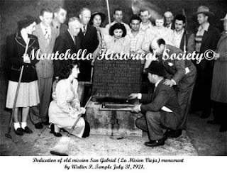
The O.G. mission site, known as "Mission Vieja" (no, not Mission Viejo) is long gone, but a little-known monument stands on its site -- on a mini-park on the corner of San Gabriel Boulevard and Lincoln Avenue, right at the edge of Montebello. It's a simple landscaped corner with a familiar El Camino Real bell and a stone marker which reads:
Take note of some of the names, especially "Walter P. Temple." We'll get to that name later in San Gabriel Valley Week!

 The marker was dedicated in 1921 to mark the sesquicentennial of the founding of the mission. Pictured right is a photo of the dedication ceremony. The site is also a California Historical Landmark (#158). It's easy to miss, and it's nearly impossible to park there, though there's a dirt clearing  just past the Montebello City Limit sign on Lincoln Avenue that could fit a car. Of course, the Whittier Narrows Recreation Area is full of awesome bike trails, and you can ride all over the place, and visit the nearby Bosque del Rio Hondo park just across San Gabriel Blvd, or ride on the Whittier Narrows Dam about a mile to the south along the Class 1 bike path. Score one for bikes in the SGV!

The San Gabriel Valley, built on history, seems to celebrate it, as well as the vast natural expanse of the Whittier Narrows area. There may or may not be more of this...stay tuned!

Tuesday, October 25, 2011

Coming In November: San Gabriel Valley Week!

The Militant Angeleno, who brought you Long Beach Week earlier this Summer and Native Week Month back in early September-early October, decided to bring it to the people to decide the theme of his next topical "Week" series.

Offering a choice between The San Fernando Valley, The San Gabriel Valley, The Westside, The Eastside (the real one, not "that" Eastside), South Los Angeles, The South Bay and The Inland Empire, The Militant put it to an online poll on This Here Blog from October 11 to October 24.

Welp, The People Have Spoken. San Gabriel Valley has led the poll results from the get-go and never faced a real contest. Of course, some of you out there who are either longtime SGV residents or SGV natives voted enthusiastically, as are some who just wanted to see an 'SGV Week.' 


The SFV and The Westside were tied for runner-up, and South Los Angeles and The Inland Empire both drew for the bronze medal. The Eastside and The South Bay also were neck-and-neck for a distant fourth place.

So there you go, it's official now. Look for The Militant Angeleno's San Gabriel Valley Week sometime this November (after The Militant does some additional militant research and plans his fact-finding missions accordingly)!

THANKS FOR VOTING!

A couple things before we move ahead: The Militant's SGV Week series will not be all about the following:

- Pasadena. The Militant digs The 'Dena and all, but there's so much more to the SGV than Pasadena. Unfortunately, that's as far as Metro Rail goes in the SGV, so there's gonna be some Metrolink trips racked up soon (Maybe a good chance to try out their new bike cars). 

- Chinese Food. Again, The Militant loves him some dimsum, boba joints, tofutarian and Szechuan, but Chinese Food in the SGV has been done. The Militant is all about uncharted territory and the road less traveled, aite?!

To be perfectly honest, Though The Militant knows a few interesting things about the SGV, he obviously doesn't know it as well as the city of Los Angeles proper. But he's totally down for the adventure and will undoubtedly learn a thing or two about the SGV as y'allz will. Soooo, if any of you SGV operatives want to drop some tips or recommendations off to The Militant, he may or may not welcome them! So send them via email to militantangeleno@gmail.com!

Friday, September 3, 2010

Celebrate Los Angeles' 229th Birthday Weekend!

Whatup, Angelenos?! Tomorrow is Los Angeles' 229th birthday, and it's so huge, most businesses will be closed on Monday! Oh wait, it's a national holiday? OK, whatever. But here's some kick-ass events to celebrate your city's b-day!

Pobladores History Walk - 6 a.m. to 12 noon, San Gabriel Mission to Olvera Street. Every true Angeleno must do this at least once in their life! Re-enact the original 9-mile journey by our City's founders on foot (Bring comfortable shoes)! The walk was canceled for the first time last year due to the Station Fire, so if you were planning on doing it last year, now is your chance! The Militant did the walk in 2007 and had a great time (the blisters were a bitch though).

2nd Annual Leimert Park Village African Art & Music Festival - 10 a.m. to 6 p.m., 43rd St. and Degnan Ave, Leimert Park (also Sunday and Monday). Enjoy "The Soul of Los Angeles" with this three-day free festival featuring African and Africa-American music, arts, crafts and food. Last year's festival was a blast, and this year's should be even bigger!

Outdoor 'L.A.' Movies At Barnsdall Park - 7:30 p.m., Barnsdall Park, Hollywood. Cap off the day with this first-in-a-series outdoor screening of famous Los Angeles-based films at Barnsdall Park. Saturday night's featured film will be 2009's 500 Days Of Summer. Upcoming films are: Sept. 11: LA Story (1991); Sept. 18: LA Confidential (1997) and Sept 25: Who Framed Roger Rabbit? (1988). The movies aren't free, they cost $10 a person, but the proceeds go to the Barnsdall Art Park Foundation and their programs.

Tuesday, December 1, 2009

The Militant's Excellent Adventure In San Dimas

Ask most Angelenos what comes to mind when they hear of "San Dimas," and they will list two things: Raging Waters and Bill and Ted's Excellent Adventure.

The Militant found himself here Monday afternoon in the far-eastern stretches of the San Gabriel Valley (though he has been even farther east before) due to unspecified circumstances. Call it fate, or mere curiosity, but the Militant found a historically fascinating locale.

While most So Cal 'burbs mark their central business district with some faux-Main Street getup, or even worse, a large, auto-oriented retail development (anchored by one or more of the following: A Target, a Best Buy, a Home Depot and a smattering of fast food chains, including a Chick-Fil-A), San Dimas was surprisingly different.

From the moment one exits the 210 at San Dimas Avenue, the environs are different from most of the arid pueblos that lie in the shadows of the San Gabriel Mountains - there's considerably more trees and shade here. Part of that lay in the town's history as a former early 19th-century settlement named Mud Springs, and later named after this saint.

Bonita Avenue, the town's main street, boasts a total Old West flair, right down to the wooden boardwalk that lines the town's shopping promenade, the architecture of the buildings (even the local Thai restaurant doesn't look out of place in Old West San Dimas) and the large-serif fonts on nearly all of the street signs. Shops ranged from a vintage Ford automobile garage (pictured right), to a gourmet food market, to a pet store, a model train shop and a hardware emporium.

For history buffs (like the Militant), pictorial markers are positioned right across the street from various historic buildings, depicting them in an earlier life, and explaining their historic significance. Some buildings were relatively self-explanatory, like the old Santa Fe train depot that now functions as the Pacific Rail Museum. But next to it stood even more morsels of history: a restored water trough for horses, a stretch of the original Santa Fe railroad track first laid here in 1887 and an old water pump that once brought the plentiful groundwater up for human consumption.

Speaking of which, the town bears its own still-natural river, Cinnamon Creek, which runs just south of the city center. The street named Cataract Ave. refers not to an opthamologist's office but to a waterfall made by the creek.

Another surprise were the people of San Dimas: Expecting a total lilywhite town where the Militant would stick out like a sore thumb and may or may not feel welcome, at least from the people walking down the street it looked surprisingly diverse. A South Asian mother and daughter stroll through the shops on Bonita, while later down the street, an African American couple point to a new dessert shop and exclaim that "This used to be a Quiznos!"

Half-jokingly, and half-honoring his '80s nostalgia, lo and behold a few blocks east on Bonita yields - yes - a Circle K mini-mart.

[Say it with the Militant now: "EXCELLENT!"]

No, the Militant didn't notice any strange things afoot here, nor did he run into some dude named Rufus, but the Militant wouldn't be surprised if other non-locals would instinctively look for a Circle-K in San Dimas. Even though, in actuality, the "Bill and Ted" films were shot on location...in Arizona.

[Say it with the Militant now: "BOGUS!"]

Heading back on Bonita, the Militant passed the San Dimas City Hall building and saw some sort of Jebediah Springfield-type statue (pictured left).

Which was all funny until he read the marker:

"JEDEDIAH STRONG SMITH"

[Say it with the Militant now: "NO WAY!"]

Turns out Smith was an Old West explorer/hunter type famous for being the first American to arrive in California over land from the east (Yo transplants, there's your forefather! LOL) and lived to the ripe old age of...32. He led an exploration party from Utah, over the Nevada desert and California mountain ranges and into Mud Springs, 183 years ago last Thursday.

Even the accoutrements of the modern retail world did not feel out of place here. A shopping center blended with the local architecture without looking faux-historically tacky. The requisite local Starbucks seemed to fit in. And the nearby Albertson's supermarket even had a public space next to it -- a pocket park with a fountain, benches and rose bushes (pictured right).

The premature dusk skies typical of mid-Autumn soon fell upon San Dimas, and the Militant naturally had to set off into the sunset (he drove here, BTW, though Foothil Transit's line 492 takes you here from the El Monte Transit Center, and one fine day in the future, the proposed Foothill Extension of the Metro Gold Line may or may not take you here as well).

The beauty of Southern California lies in its surprises that reveal themselves before you if only you pay attention, get out of the car and walk around a little. San Dimas proved to be an, um, excellent example of that.