Showing posts with label Venice Beach. Show all posts

Thursday, August 6, 2015

The Militant's Epic Militant CicLAvia Tour 4.1!!!!


Interactive map - click and zoom! Click here to view the map separately!


So we're already nearly 5 years into the CicLAvia thing, haven't we had enough already?

OF COURSE NOT!

Just when we got over the last CicLAvia, along comes the XIVth edition of America's largest open streets event (Oh you know it, baby), and the third of four this year (But wait a minute, the last Epic Militant CicLAvia Tour was number 10.0, why is this one 4.1? You might ask. Well, The Militant categorizes his CicLAvia routes into unique versions of routes, and since this route is basically a modification of the fourth unique route from April 2013 (The legendary 17-mile "To The Sea" edition), The Militant categorizes Sunday's route as 4.1. Got it?). But even though this one is but a slight change from the Epic Venice Boulevard Route, there's a lot more new sights to see, especially along Washington Boulevard/Washington place, plus some locales he forgot to add during the 4.0 posting. Anyways, you know the drill, Share this link on your Facebooks and Twitters, visit the sights yourselves -- and if you do, Tweet with the hashtag, #EpicCicLAviaTour to stroke The Militant's ego and make him feel like his several days of staying up late at night to research and write all this was worth his while. And most of all, Stay Militant and Enjoy CicLAvia this Sunday! See you or not see you on the streets!

1. Culver City Metro Expo Line Station/Site of Culver Junction
2012
Venice and National boulevards, Culver City

You may or may not have arrived at CicLAvia via the Metro Expo Line, which is the modern reincarnation of the Pacific Electric Santa Monica Air Line. Not only can you experience Los Angeles' transportation present, but you can glimpse its future (Phase 2 of the Expo Line, which opens next year, is clearly visible towards the west), and you're in the clear presence of its past -- this area is also the site of Culver Junction, where not one, not two, but three Pacific Electric Red Car lines converged, going to Santa Monica, Venice and Redondo Beach. TIP: Make sure you buy a Day Pass or that your TAP card is well-loaded before CicLAvia, so you don't have to queue at the ticket machines! The Militant says "You're Welcome."

2. Ince Boulevard/The Culver Studios
1918
Ince Blvd & Washington Ave, Culver City

As you make your first turn going westbound on the CicLAvia route, take note of the street name: Ince.

If you know your Culver City history, the town was a planned community built by landowner Harry H. Culver, a Spanish-American war veteran who worked for SFV pioneer Isaac N. Van Nuys and purchased a large section of the old Rancho La Ballona. In 1913 he established the town and filmmaker Thomas Ince moved his operation here from Pacific Palisades (via his Triangle Studios down the street -- more on this later...) and bought this section of land from Culver himself to establish the Ince Studio, which featured a large mansion fashioned after George Washington's Mt. Vernon residence, that remains in full view today. Ince's studio was sold to Cecil B. DeMille after his mysterious death and had changed hands and names over the years, finally adopting its current name of The Culver Studios in 1970. Legendary Hollywood films were shot this studio, including Gone With The Wind, King Kong, E.T. and The Matrix.
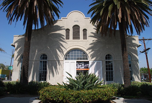
3. Pacific Electric Ivy Substation
1907
Venice and Culver boulevards, Palms

Downtown  Culver City is already rich in retail and artistic activity, and has a bevy of well-known eateries, like the popular Father's Office. The Militant can cover that in its own post (and kinda already did before). But welcoming people to Downtown Culver City along Venice Blvd (though technically located in the Los Angeles neighborhood of Palms), a block from the Culver City station is an appropriate link to the past - the Ivy Substation. The single-story Mission Revival-style structure served as a powerhouse for the Pacific Electric Railway from 1907 to 1953, when the Expo Line's predecessor, the Santa Monica Air Line, ceased operation. Today, it's a 99-seat venue for The Actor's Gang theatre company, renovated in the early 1990s. How interesting that a building originally built for transportation infrastructure was repurposed into a building for the arts, which in turn attract people using the new transportation infrastructure.
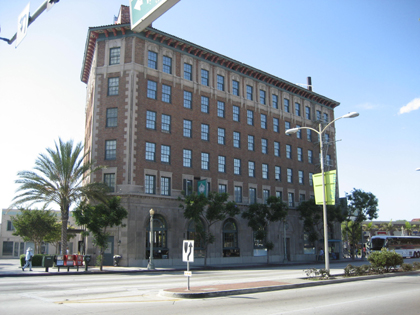
4. Culver Hotel
1924
9400 Culver Blvd, Culver City

This 6-story triangular building, originally named Hotel Hunt, opened in 1924 as Culver City's first skyscraper (it was the tallest building between Downtown Los Angeles and Venice)  and housed Harry Culver's personal office on the second floor. Numerous Hollywood stars have stayed here, such as Joan Crawford, Clark Gable, Greta Garbo and Ronald Reagan, and most notably the little people actors who played the Munchkins in The Wizard of Oz during its filming down the street. Actor John Wayne was one of the later owners, and it was fully restored in the 1990s.

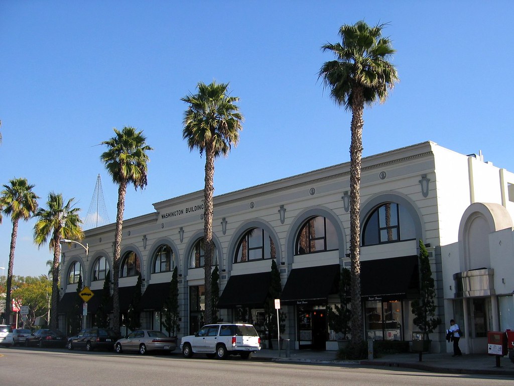
5. The Washington Building
1927
9718 W. Washington Blvd, Culver City

Culver City's other 1920s-era triangular building is just down the street from The Culver Hotel. Built by Charles E. Lindblade, a business associate of Harry Culver who also bears a city street name of his own, this Beaux Arts-style building was designed by Arthur D. Scholz and Orville L. Clark. As it is today, the building housed numerous retail and office businesses over the years, including the Culver City post office, the MGM Studios Fan Club and Lindblade's real estate company.

6. Kirk Douglas Theatre/Culver Theatre
1946
9820 W Washington Blvd, Culver City

Built in 1946 as The Culver Theatre, a 1,100-seat Streamline Moderne cinema designed by Karl G. Moeller that screened 20th Century Fox films as part of the Fox West Coast Theatres chain.
It was later operated by the National General and Mann Pictures chains, and finally as an independent theatre. It was split into three screens circa 1970s, and closed in 1989. In 1994, it suffered damage from the 1994 Northridge Earthquake and underwent a major $8 million renovation later in the '90s, re-opening in 2004 as The Kirk Douglas Theatre (with Spartacus himself as a the major contributor in the renovation), operated by Center Theatre Group. It currently features two stages, one seating about 300 and a smaller stage seating around 100.


7. Sony Pictures Studios/MGM Studios
1915
10202 West Washington Boulevard, Culver City

One can't mention Culver City without mentioning its massive movie lot, originally Thomas Ince's (remember him?) Triangle Studios operation until he moved to the Culver Studios property and sold this site to D.W. Griffith and Mack Sennett.  In 1918, the studio was sold to Samuel Goldwyn, which became Metro Goldwyn Mayer in 1924 (following the merger of Metro Pictures, Goldwyn Studios and Louis B. Mayer Productions). It became the Columbia Pictures studios in 1989 and Sony Pictures Studios from 1992 to the present.

On this lot was filmed a countless list of Hollywood productions, most notably The Wizard of Oz in 1939 (you will be riding next to the actual Land of Oz, think about that...), and currently, TV shows like Jeopardy! and Wheel Of Fortune.

10. La Ballona Elementary School
1865
10915 W Washington Blvd, Culver City

This local school is literally some old school Culver City right heah! Established in 1865, it's one of the oldest schools in Los Angeles County still in operation. Back in the day, it had an enrollment of 158 pupils between the ages of 5-15, being taught by one teacher, a Miss Craft who made $50 a month, and the school year lasted seven months, since it revolved around the agricultural calendar of the surrounding area.
When it was established, it was in an unincorporated area that eventually became Palms, which was annexed to the City of Los Angeles in 1914. When Culver City was founded the year before, it had no schools within its boundaries, so another school was built in the area in 1916. Eventually La Ballona was annexed into Culver City in 1920.

9. NFL Network
2003
10950 W. Washington Blvd, Culver City

Well, well well. The TV network and web site run by the National Football League is based in an area that hasn't had a football team since 1994. Let that irony sink in for a second.

10. King Fahd Mosque
1995
10980 Washington Boulevard, Culver City

This Islamic house of worship was built in 1995 as a gift from Saudi Prince Abdulaziz Bin Fahd to serve the growing community of Muslims in the Westside, named after the king of Saudi Arabia at the time. Its facade features hand made marble tiles from Turkey, and a 72 foot-high minaret topped with a gold leaf crescent.


11. Tellefson Park/Rollerdrome Site
1976/1928
1105 W. Washington Pl, Culver City

There's a designated activity hub here at this 1.5-acre Culver City park, which was dedicated in 1976 as part of the U.S. Bicentennial celebrations. It was named after former Culver City councilman and city attorney Mike Tellefson, who served the city for 31 years. In 2013, the body of a suicide victim was discovered in the park.

But longtime Culver Citizens remember this site as a legendary roller skating rink called The Rollerdrome,  a wooden structure which opened in 1928 and had a characteristic rounded roof. Roller skating events were centered around the rink's organ, which was played by a live organist, and provided memorable evenings for local families and youths. It was torn down in 1970, which was a shame, since roller skating enjoyed a renaissance of sorts in the '70s.

12. Tito's Tacos
1959
11222 Washington Pl, Culver City

Many Angelenos already know of this longtime Westside (American) taco joint known as Tito's Tacos, which as we all know, was founded in 1959 by a businessman who may or may not be an actual Mexican guy named Tito. Everyone has their opinion on Tito's, but three things are indisputable truths: 1) It's a Culver City Institution; 2) It's not authentic Mexican food and 3) People come here for the nostalgia anyway. But this small business, currently owned by Señora Lynne Davidson, which makes roughly $310,000 in profits annually, has been in the news recently, and not in a good way to us CicLAvians.
See, Señora Davidson is threatening to sue Culver City government for lost revenue because the CicLAvia route will cut off access to her customer base (which crowd the tiny parking lot and forces motorists to circle the block and/or shortcut the lot from the little alley). The pro-CicLAvia city council has assured her she be trippin' over nothin' and everything will be aite, but she ain't got no time for dat.

So, CicLAvians, we've all heard this before. Business "A" is pissed at CicLAvia for "shutting down their business" during CicLA-Sunday. But CicLAvians swarm the place and the said business makes a lot of moolah. It's tempting to boycott, but it's perhaps a more powerful and more noble thing to prove Señora Davidson that she's just plain loca. So what else can you do?

You can also try their delicious burritos, chips and salsa -- enchiladas ooh, because the only thing better than a Tito's Taco, is two. Again -- the only thing better than a Tito's Taco, is two.

But seriously, Señora Davidson, you have no reason to fear CicLAvia this Sunday. Because we are coming. And you will get A LOT of business. And you can be rest assured that unlike your car-oriented customers, we won't be crashing into your wall. [MIC DROP]

UPDATE: It seems that Titogate has attracted a lot of negative press for the 56 year-old Culver City institution. However, The Militant is happy to report that as of early Friday afternoon, Tito's Tacos has changed their tune (no, not their catchy jingle, that should never change) and has worked things out with the CicLAvia organization, who is providing support for Tito's bicycle and automobile customers alike. So drop the Tito's hate everyone, they cool now:


13. The Oval District/Palm Place
1912
Area within Washington Place, McLaughlin Ave, Venice Blvd & Inglewood Blvd, Mar Vista

You might not see much from the street level, but this neighborhood just north of the CicLAvia route, a Historic Preservation Overlay Zone known as "The Oval District" is one of the first automobile-oriented property tract developments in Southern California.

When seen from a map or an aerial view. the streets of this 200-unit housing development of predominantly 1- and 2-story homes resembles an hourglass shape with an oval road in the center (which caught The Militant's eye and caused him to investigate the history of the place).

The 137-acre neighborhood was developed in 1912 by a Lillian Charnock Price (there is a "Charnock Road" two blocks north of Venice, BTW) who hired renowned landscape architect and urban planner Wilber David Cook, Jr. (who worked for legendary late 19th/early20th-century landscape architect Frederick Law Olmsted to design an "Aristocratic Suburb" marketed as “Palm Place."

The large-sized lots were unique, and park-like in their large setback from the street and the palm tree-lined parkways, but only a small number of homes were built. Price sold the development to Robert Sheman, who was the stepson of Moses Sherman, the developer of the Los Angeles and Pacific Railway, which built the original rail line on nearby Venice Boulevard. What was originally intended to be the first car-oriented development was going to be a transit-oriented development!

But those didn't sell either. The lots were still too large and pricey. So Sherman sold it to a financier group that marketed it as "Marshall Manor" in 1920 and interest began to pick up. But it wasn't until after World War II, when suburbanization was in vogue and Los Angeles' Westside development boom commenced, that the rest of the lots got built.

14. Mar Vista Hill (a.k.a. The 'Mar Vista' in Mar Vista)
1924
Centinela Ave & Rose Ave, Mar Vista

Everyone know that "Mar Vista" is Español for "sea view." But riding along Centinela or Venice during CicLAvia, you can't even see the sea. Where is it?

Well, The Militant will tell you where to see the "Mar Vista" in Mar Vista. He implores you to take a short detour from the CicLAvia route and continue north along Centinela Avenue, switch your gears (or pedal harder, you fixie heads), and go up the hill (Mar Vista Hill) until you reach Rose Avenue. Then turn right and go  up the hill to the open space that contains the baseball field and community garden. Look to the west, stand on top of the telephone poles laying on the ground in front of the small parking lot, and you can have a semi-unobstructed (damn you, DWP power lines!) view of Santa Monica Bay from the Palos Verdes peninsula to the Santa Monica Mountains.

Mar Vista Hill is a 203-foot-above-sea-level promontory that was once a garbage dump, and was later the site of the Venice Reservoir in 1940 (smart, huh). The reservoir was decommissioned in the 1960s and replaced with the baseball fields you see today.

So come on up to Mar Vista Hill, where you can see the sea, to see all that you can see!

Go visit Mar Vista Hill and tweet a pic of the ocean with the hashtag #EpicCicLAviaTour!


15. State Route CA 187
1964
Venice Boulevard between Lincoln Blvd and the 10 Freeway

You may or may not know that Venice Boulevard, in addition to being a two-time CicLAvia route, was also a Pacific Electric Red Car line, but did you know it's also a designated California State Highway?

In 1964, CalTrans designated State Route 187 starting at the Pacific Ocean. In 1994, it was shortened to the 5.4 miles from Lincoln Boulevard to the 10 Freeway.

The number "187" also happens to be a reference to the California Penal Code designation for murder, which is most likely why a young, '90s-era, pre-commercialized Snoop Dogg is standing by the sign in this photo.

17. Mario's Brothers Market
12904 Venice Blvd, Mar Vista

No deep history behind this neighborhood Mexican corner market on Venice and Beethoven, but the name caught The Militant's eye. He's seen some of you CicLAvians ride in CicLAvia in Mario/Nintendo cosplay, so this would be a perfect photo/selfie opportunity.

While you're here, support the business and buy something inside. Maybe it really is owned by a Mario. Or a Luigi. Ask where The Princess is. If they're successful enough, they might move to a larger location and rename themselves "Super Mario's Brothers."

Tweet a pic of yourself (or your group) in front of Mario's Brothers with the hashtag "#EpicCicLAviaTour"!


18. Venice High School
1920
13000 Venice Blvd, Venice

Venice's namesake secondary school was one of three on-location sites for Rydell High in the 1978 motion picture Greaseand was the school scene in the Britney Spears video for her debut hit, "...Baby One More Time." The main Moderne-style school buildings, built in 1935-37  were designed by local architects John C. Austin and Frederick M. Ashley, who also designed the Griffith Observatory.
The campus is also famous for its statue of legendary Hollywood actress and famous alumna Myrna Loy at the front of the school. Other famous alumni include Beau Bridges, Crispin Glover, the late Ivory Queen of Soul, Teena Marie and In-N-Out Burger founder Harry Snyder. Go Gondoliers!

19. Old Venice Civic Center
1911
681-685 Venice Blvd, Venice

Venice, originally founded as part of Santa Monica, seceded from that city in 1911 and for the next 15 years, functioned as an incorporated city. In 1926, due to political mismanagement and crumbling infrastructure, it was annexed into the City of Los Angeles. Its vestigial remnants of its civic government still remain, though. The old Venice City Hall still stands at 685 Venice Blvd (pictured), now the venue for Beyond Baroque Theatre. Next door on 681 Venice Blvd is the old Venice Police Station, now the home of the Social Public Arts Resource Center (SPARC), the community arts nonprofit that spearheaded the modern urban mural movement. It's interesting to note that both of these government buildings were adaptively re-used for arts purposes. The Militant is looking at the old LAPD Parker Center in DTLA and wonders if it could make some sort of badass performing arts venue...

20. Electric Avenue
1905
Electric Ave and Venice Blvd, Venice

No, '80s singer Eddy Grant didn't rock down to this street to take it higher (VROOOM!) But this street was so-named because it was one of the old Pacific Electric Red Car rights-of-way, which included Pacific Avenue (of course) and Venice Blvd. The railway, of course, was built to serve (and sell property in and around) Abbot Kinney's Venice of America development. Rock on to Electric Avenue towards Brooks Avenue and look to your left for actual remnants of Pacific Electric tracks at Millwood Avenue, Westminster Avenue and Broadway. If that kind of stuff excites you, be on the look out for The Militant's upcoming Pacific Electric Archaeology Map (view the preview edition map here, including Venice sites). And then we take it higher (Oh yeah)!

21. Abbot Kinney Blvd
1992
Abbot Kinney Blvd between Washington Blvd and Main Street

New arrivals to Los Angeles are likely oblivious to the fact that Venice's upscale arts and boutique corridor is technically one of its newest streets. Until 1992, that stretch was confusingly known as West Washington Blvd, which, along with Washington Street and Washington Way, was a source of disorientation among motorists. A small group of business owners lobbied to re-name the stretch after the community's founder. Ignorance of local history was so bad back then, that then-City Councilman Zev Yaroslavsky, who grew up in the Westside, asked aloud at a Los Angeles City Council committee meeting, "Who is Abbot Kinney?" (Really, Zev?!?!) Thankfully, due to a street name change, and other things, we're a lot better at our Los Angeles history.

22. Venice Of America Centennial Park
2005
Venice & Abbot Kinney boulevards

This park, which neighbors the Venice-Abbot Kinney Memorial Branch Library and built for Venice's centennial year of 2005,  was made on the very same median that carried the Pacific Electric Railway tracks, and in honor of that, the design on the park's paving resembles that of railroad tracks. The Militant went there in a famous bike ride to Venice Beach in 2008 and encountered a bunch of ducks walking in this park.
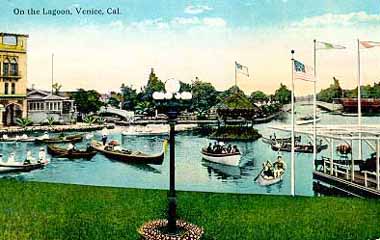
23. Venice Traffic Circle and the Lost Canals
1929
Grand and Windward avenues, Venice

Traffic circles, or "roundabouts" as they're known in Britain, are not a common sight in the US, much less Los Angeles, though a dozen or so are known to exist here (more in a future post). So what up with this one? This part of Venice was part of Abbot Kinney's original "Venice of America," replete with its own canals. But unlike their Italian counterpart, these canals were not physically connected to the ocean, and the water had gone stagnant and kinda gross. By the 1920s, the Venice city infrastructure was falling apart (which meant little resources or political will to maintain the canals), and the automobile had started to conquer the streets of the Southland. So they were filled in circa 1929. The CicLAvia course on Grand Avenue was once the Grand Canal, and the traffic circle was formerly the location of a large saltwater swimming lagoon. The surviving canals, located south of Venice Blvd, were built by a different developer a couple years after Kinney's canals opened.

24. Windward Hotel/Pacific Electric Station
1905
Windward and Pacific avenues, Venice

The Windward Hotel, now a traveler's hostel, is not only the oldest hotel building in Venice, but its eastern ground floor entrance also functioned as Venice's Pacific Electric station. For the first half of the 20th Century, Venice was a popular western destination for the Red Cars, and the preferred way to go. North of Windward Way, there was no Pacific Avenue, but a dedicated "Trolleyway" for the Red Cars. When passengers disembarked at the Venice station before 1929, they were treated to an awe-inspiring view of the large lagoon (now the traffic circle) and canals just across the street, welcoming them to Venice of America. Now, for CicLAvia, when you arrive here, use your imagination and pretend to be transported back to a time when you didn't need cars to get around. On this day, it won't be that hard.

25. Pacific Electric Grand Canal Bridge
1905
Grand Canal at Venice Blvd, Venice

Ride just a few blocks down Pacific Avenue to Venice Boulevard to see Venice's characteristic namesake -- it's system of canals, built in 1905 by the aforementioned Mr. Kinney. The ornate concrete bridge spanning two side of the Los Angeles City parking lot near the Grand Canal is the original bridge that carried the Pacific Electric Venice Short Line tracks until 1950.

Tuesday, April 23, 2013

Sea-cLAvia!


Two and a half years since the advent of Los Angeles' own ciclovia event, we have the longest CicLAvia route to date at a length of 16 miles, from El Pueblo to la playa, and going as far west as it can go, to the iconic Angeleno seaside playground known as Venice Beach, just yards from the famed boardwalk. The planners call it "CicLAvia to the Sea." The Militant will skip the redundant syllables and come up with his own portmanteau: Sea-cLAvia.

The Militant was there, and has yet to miss a CicLAvia (and plans never to do so, unless they make this a daily event), so he got on his chromoly steed and rode westward.

Had it really been that long since his the last CicLAvia in October - half a year ago? CicLAvia season has now begun, and Angelenos have officially sprung back into life.

We haven't seen THIS since last October...
True to CicLAvia fashion, there was nary a cloud in the sky (except at the beach, which burned off eventually), the temperature somewhere between 74 and 80 degrees, zero arrests (compared to 171 out in Coachella) and hundreds of thousands of smiling faces.

The severely undercounted estimate of 100,000 participants (which is a hard figure to quantify with any precision whatsoever) had to have been surpassed, as the past 3 or 4 have already broken the 100K mark. The Militant's estimate is some 225,000 people for CicLAvia VI.

Westbound CicLAvians outnumber the eastbound ones on Venice Blvd.
Because the event lasts an all-too-short five hours -- a major pet peeve of The Militant since CicLAvia began -- He skipped the Downtown-to-Westlake segment and headed for the goods.

He passed by several of his listed points of interest in his Epic Militant CicLAvia Tour 4,0 post, and even had some nice chats with fellow riders, even educating one on where the Expo Line was headed to in three years (he knew there was construction in Santa Monica, but for some reason didn't put two and two together...). He saw a family bang on percussion instruments from their balcony on Venice Blvd to the delight of cyclists, Brazilian capoeira on Venice, Hare Krishnas singing, DJs spinning, and even rode along with the mayor, as well as a likely future mayor.

Bikes backed up on Venice at Sawtelle. There's something about being close to the 405 that creates congestion. 
The biggest complaint shared by most was the traffic bottlenecks west of Culver City. Yep, even without cars, the Westside still has the worst traffic in town, and CicLAvia was proof. Most of it had to do with the fact that the eastbound lanes of most of Venice Blvd were still open to normal auto traffic, while both directions of the CicLAvia flow had to share the westbound lanes.
But CicLAvia being a work in progress, expect to not experience that next time we have see a Sea-cLAvia route.

The Metro Expo Line, of which its current western terminus in Culver City was one of three directly located along the route was put to the test on Sunday, not just ferrying CicLAvians and their bikes, but transporting literature fans to and from the Los Angeles Times Festival of Books at USC. A number of operatives have also reported to The Militant that trains were still handling CicLAvians even several hours after the streets had let cars back in.

And of course, there's the whole time issue. Again folks, an eight-hour CicLavia. It's totally possible.

The next CicLavia route on June 23rd will be along Wilshire Blvd, expected to run from Grand Avenue in DTLA to Fairfax Avenue, just outside of LACMA. If that indeed will be the route, it will be 6 miles long -- the shortest route ever (CicLAvia started at 7 miles). They should continue the route either north along Fairfax to Sunset Blvd (imagine passing by Farmer's Market, Canter's and Oki-Dog), or head south along Fairfax through Little Ethiopia and onto La Cienega to the Expo Line station for a way to transport people in and out of the area. We'll also get a third this year on October 6, which may or may not be the classic CicLAvia route seen in the first three runs.

Speaking of future CicLAvias, rumor has it from operative reports that there will likely be four CicLAvias next year, working towards 5-6 scheduled through the year, perhaps every other month (leaving out December and January as the off-season). Yes sir, may we have another?

More pics of course!

Homies for Historic Homes, at the Casas Alicia Restoration Project on Alvarado: "DON'T MESS WITH THESE PROPERTIES! HOMIES "R" WORKING ON THEM!! XV3HI!"
The Old Venice Civic Center turned quite festive on Sunday.
Capoeira on Venice Blvd! Little Brasil comes alive for CicLAvia!
CicLAvia with the current mayor...
...And CicLAvia with the next mayor (Face it, we all know he's gonna win).

Thursday, April 18, 2013

The Militant's Epic Militant CicLAvia Tour 4.0!!!!


View The Militant Angeleno's CicLAvia Tour 4.0! in a larger map


This Sunday's CicLAvia route, the sixth iteration of the car-free, open-streets event, and the first of three planned for this year, will be the longest and most ambitious to date. Adventurous Angelenos can bike, skate, walk or run for the 16 miles from Downtown Los Angeles to Venice Beach. Only time will tell if five all-too-quick hours is enough time for people to make it from end-to-end and back.

Already sporting bicycle lanes, Venice Boulevard is all-too familiar for cross-town cyclists. It's also the location where Mayor Villaraigosa got his legendary cycling injury in July 2010 and where The Militant biked to Venice Beach two years before then. But this time, you ain't restricted to no 4-foot bike lane!

In the spirit of CicLAvia, as a way for us to appreciate our City a little more in a different way, The Militant has been writing these guides from the beginning to help you learn a little more about our town. So here it is, for your reading (and discovering) pleasure, listed from from east to west, the 32 points of interest of The Militant's Epic Militant CicLAvia Tour 4.0!!!!


1. Italian Hall
1908
622 1/2 North Main Street, Downtown

This 105-year old building is the oldest vestige of what was once Los Angeles' Little Italy neighborhood. Built as a cultural center to serve the ethnic community, which has been present in the city since the 1820s, today, the well-restored structure, part of the El Pueblo De Los Angeles Historical Monument (a historical tour destination unto itself), is the site of Los Angeles' Italian American Museum, which will display artifacts and exhibits from the Little Italy district and the contributions of Italian Angelenos.

2. The Plaza
1825
You Can't Miss It

Los Angeles has (long exhale) often been criticized for not having a "center," The Militant countered with both an ancient center and a regional center. But The Plaza, for nearly two centuries (longer than any one of us has been here, right?), functioned as the undisputed Center of Los Angeles. Forever standing in the shadow of its tourist-heavy younger cousin Olvera Street (which you've all been to, so The Militant isn't adding it to his Epic CicLAvia Tour), The Plaza was really Los Angeles' own town square.

What's historic is not the hexagonal, wrought-iron bandstand (known as the Kiosko) -- that was built in the late 1940s as part of an urban renewal project for the El Pueblo district -- but the circular space itself, which was built in 1825 and actually functioned part-time as Los Angeles' first-ever sporting venue (bullfights were staged there in the 1800s). This was actually the third location of The Plaza. It was first established at the time of Los Angeles' founding 231 years ago, but much closer to The River. Flooding in the 1810s forced The Plaza to re-locate twice to higher ground. Hey, the third time's the charm...

3. Site of Los Angeles' French Quarter
c. 1830s-1960s
Aliso Street and Arcadia Street, Downtown

In addition to an Italian community, beleive it or non, Los Angeles had a French ethnic enclave, called The French Quarter. Before today's Hollywood Freeway trench and nearby parking lots was a bustling community of Franco-American businesses and institutions. When Frenchman Jean-Louis Vignes bought up land on the Yangna village site a few blocks east on Aliso Street, he essentially became the anchor of our French community. In 1912, businessman Marius Taix opened the Champ D'Or Hotel on Commercial Street and then opened his namesake restaurant in the same building in 1927. But the most famous constibution to our French Quarter was Philippe Mathieu's restaurant, which opened in various locations in the area. In 1918, his restaurant on 246 Aliso Street gave birth to The French Dip sandwich. But urban development (and cultural assimilation by the community) destroyed the French Quarter. In 1951, Philippe's moved a few blocks north to their present location on Alameda Street due to Hollywood Freeway construction, and Monsieur Taix's restaurant moved a decade later to Echo Park.

4. Triforium
1975
Main and Temple Streets, Downtown

This $925,000 light-and-sound public art sculpture was designed by artist Joseph Young in the mid '70s as "a tribute to the unfinished, kaleidoscopic nature of Los Angeles." Intended to be Los Angeles' own iconic answer to the Eiffel Tower or The Statue of Liberty, it was also originally planned to be equipped with motion sensors and skyward-aiming laser beams. Budget constraints put a stop to that. Despite its shortcomings, it was the world's first public sculpture to integrate light and sound by use of a computer, something us 21st century types take for granted every day (cough LA Live cough).

Though it's somewhat dated in its '70s-impression-of-the-future asesthetic (But hey, so is Star Wars), all it really needs to be hip to today's standards (it's already got its own Facebook page) is an iPod interface. Cultural Affairs Department, are you listening?

The Triforium's lights are on daily from 6-8 a.m. and from 5-7 p.m. (6-8 p.m. PDT).

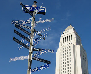
5. Los Angeles Sister Cities Monument
Circa late 1980s
1st and Main streets, Downtown

On the northeast corner of 1st and Main streets stands a pole bearing signs (in the "Blue Blade" style, no less) for every one of Los Angeles' 25 Sister Cities, each pointing towards their location. The signs range from Lusaka, Zambia (the farthest sister city, 10,017 miles) to Vancouver, Canada (the nearest, 1,081 miles) and everywhere in between. Nagoya, Japan is Los Angeles' oldest sister city (1959); Yerevan, Armenia is the newest (2007). Los Angeles, an Olympic host city (1932, 1984) also has that in common with sister cities Athens (1896, 2004), Berlin (1936), Mexico City (1968) and Vancouver (2010). Okay, the Militant is just filling up this paragraph with mindless trivia.

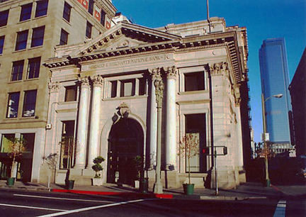
6. Farmers and Merchants Bank Building
1905
401 S. Main Street, Downtown

When they say "The Old Bank District," they're probably talking about this one. One of Los Angeles' early financial institutions, and also an example of historic preservation, this early 1900s Classical Revival building served as the home for Isaias Hellman's Farmers and Merchants Bank, which helped Harrison Gray Otis establish the Los Angeles Times and Edward Doheny drill for oil in the Westside. The building is used for events and filming today, and is on both the National Register of Historic Places and the Los Angeles Historic-Cultural Monument list.

7. Pacific Electric Building
1905
6th and Main streets, Downtown

Before 7th Street/Metro Center, before Union Station, was Los Angeles' O.G. transit hub, the grand headquarters of the Pacific Electric Railway. At one point the largest building in Los Angeles, the facility served trains coming in on street level along Main Street, as well as a larger elevated multi tracked platform area on the east side of the building. From here, you could take trains to all points south and east, such as San Pedro, Long Beach, Santa Ana and Huntington Beach. And the upper floors contained offices and executive lounges. The building went vacant following the fall of the P.E. in the 1960s but now lives on today as loft apartments. The 1908 Cole's P.E. Buffet restaurant (a.k.a. Philippe's bitter rival in terms of the French Dip sammich), on the north side of the building, is still in operation today.

8. St. Vincent Court
1868
St. Vincent Ct and 7th Street, Downtown

You'd hardly knew it was there, but this alley nestled between Broadway and Hill (blink and you'll miss it!), with its decorative brick pavement and European decor, seemingly belongs to another world. Originally the site of a Catholic college that was the predecessor of today's Loyola Marymount University, today it's a unique food court featuring Armenian and Middle Eastern eateries. The Militant calls it, "Littler Armenia." Check out this Militant Angeleno post on St. Vincent Court from 2008 for more info!

9. Wilshire Grand Hotel
1952
7th and Figueroa streets, Downtown

What we see today as the Wilshire Grand Hotel is the latest in a long lineage of hotels that operated from that building. Originally built as the Los Angeles Statler Hotel (one of a dozen nationwide in that chain) in 1952, it became the Statler Hilton, then the Los Angeles Hilton, then the Omni Los Angeles Hotel, and finally the Wilshire Grand. Take a good look at this hotel, though - the hotel's owner, Korean Air Lines, is in the process of demolishing it to put up the next tallest building in Los Angeles.

10. City View Lofts/Young's Market Company Building
1924
1610 W. 7th St., Pico-Union

Ever wondered what's the deal with this 4-story Italian Renaissance-style building? It was built in 1924 as a liquor warehouse and original headquarters for Young's Market Company, which still operates today as the largest liquor distributor in the West. This building features actual marble columns and a decorative frieze made of terra cotta. The company, in the roaring, pre-depression 1920s, just felt like it. The building was looted and burned in the 1992 Riots and was rehabbed in 1997 to become the City View lofts. The building is in the National Register of Historic Places.

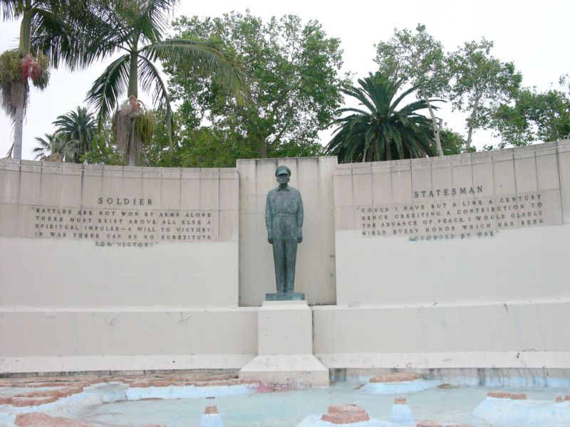
11. Gen. Douglas MacArthur Monument
1955
Southeast corner of MacArthur Park, Westlake

It's sort of strange how a monument to the park's namesake seems almost invisible (Gen John Pershing, MacArthur's WWI counterpart, could totally identify). In fact, most people don't know it's even there, but on the southeast shore of the lake is a dormant memorial fountain featuring a statue of the WWII general overlooking a model of the Pacific theatre (no, not that one) where he led allied forces to eventual victory. It was designed and built in 1955 by Roger Noble Burnham, who previously sculpted the Tommy Trojan statue on the USC campus and taught at the Otis Art School, formerly located nearby.

12. Casas Alicia Restoration Project
1904/1908 (Project began 2010)
1115 S. Alvarado Street, Pico-Union

Breaking up the commercial bustle of Alvarado Street in the Pico-Union District is a pair of old-school historic homes - the Casas Alicia Restoration Project of the Pico Union Housing Corporation. A pair of historic houses were moved from nearby streets onto Alvarado, which will be restored for community use. These are not just any old-school Los Angeles homes though -- The Jevne Residence (1904) was home of grocery company owner Jesse A. Jevne, who was also director of First National Bank and Southern California Savings Bank. The Colonial Revival Foursquare house was designed by Frederick Roehrig who also crafted Pasadena's Hotel Green. The other house was the Harris Newmark Residence (1908), once home of the very influential Angeleno who was one of the founding members of such institutions as the Los Angeles Chamber of Commerce, the Los Angeles Public Library, The Southwest Museum and the B'nai B'rith Congregation, of which he was considered the patriarch of our City's Jewish community. The Craftsman house was designed by Summer P. Hunt, one of the architects of the Automobile Association of Southern California building on Figueroa and Adams.

13. Iglesia Adventista Central/1st Church of Christ, Scientist
1912
1366 S. Alvarado Street, Pico-Union

Currently the site of a 7th Day Adventist Church catering to a Latino congregation, this 101-year old Mediterranean Romanesque Revival house of worship has changed owners, and even denominations, and has had a long, and even dark, history behind it. Built in 1912 as the 1st Church of Christ, Scientist, it served its Christian Science congregation for six decades, before it became a Jewish synagogue for a few years. In the mid-1970s, it became the Los Angeles location of The People's Temple, the cult founded by Jim Jones, who infamously led over 900 his followers to live in a commune in Jonestown, Guyana, and consequently, to die in the largest mass-suicide in history (which spawned the euphemism, "Don't drink the Kool-Aid"). The current Adventist church has been there since the late 1970s, since, Jim Jones uh...couldn't really use it anymore. The church structure was inducted into the National Register of Historic Sites in 1984.

14. Hoover Street (City Boundary)
1850
Hoover Street, Pico-Union

CicLAvia only runs for a few yards on this street, but note how all the streets east of Hoover run in a diagonal fashion, and all the streets west run perfectly east-west. Yes, Virginia, Los Angeles was not always big and sprawled. From 1850 to 1896, Hoover was the original western boundary of the City of Los Angeles, which meant that 120 years ago, you'd be on the Westside. On April 2, 1896, the "Western Addition" was annexed into the City, extending the boundaries a few miles west to Arlington Avenue (more on this latter...)

15. Angelus-Rosedale Cemetery
1884
1831 W. Washington Blvd (Venice Blvd and Normandie Avenue)

This 65-acre memorial park, originally established as Rosedale Cemetery, has been serving Los Angeles for the past 129 years, and is the final resting place of a number of historic Angelenos, such as Port of Los Angeles founder Phineas Banning, the City of Burbank's namesake Dr. David Burbank, jazz legend Eric Dolphy, actress Hattie McDaniel and mayors George Alexander, Arthur C. Harper, Owen McAleer, John G. Nichols, Frank Rader and Frederick T. Woodman. One of the most notable graves is that of Catalina Island developer George Shatto, who is interred in a pyramid!

16. Arlington Avenue (City Boundary)
1909
Arlington Ave, Arlington Heights

Continuing the Los Angeles City Boundary history, Arlington Avenue was once the westernmost border of the City from 1896 to 1909, when the Colegrove Addition (which stretched north towards Hollywood) was annexed into the City. Note how the street dramatically widens west of Arlington - that, of course, was to accommodate both automobiles and the Pacific Electric Red Car tracks, which run the rest of the way along Venice Blvd.


17. Victoria Park
1908
North of Venice Blvd, between Crenshaw Ave and West Blvd

This semi-gated community is come to a unique collection of craftsman homes built in the early 1900s decade, arranged on the circular Victoria Park Place. All of the homes are about a century old and are listed on the National Register of Historic Places or are recognized as Los Angeles City Historic-Cultural Monuments. The only entry, though, is on Windsor Drive, off of Pico Blvd. If you're into old-timey homes, this is one of the true hidden jewels of Los Angeles.

18. Site of Vineyard Junction
1901-1963
Venice and San Vicente boulevards

You'll know you've arrived when you cross under the bridge that crosses over Venice Blvd. The north side of the street once carried three streetcar tracks, and the south side carried automobile traffic, while a different set of tracks diverged along San Vicente Blvd. Covered in a July, 2007 Militant Angeleno blog post, this area, now occupied by the Midtown Crossing shopping center, was a crossing of a different kind a century ago when it functioned as a major junction and transfer facility for the Pacific Electric Railway and the Los Angeles Railway streetcars. It was the site of the worst accident in the history of the Red Car system a century ago, killing 14 and injuring 200, and was once planned as the western terminus of a proposed Pacific Electric subway line from the Ambassador Hotel. The Los Angeles Railway's "P" line ended at Pico and Rimpau in a famous loop, and several bus lines terminated here as well. Pacific Electric service ended here in 1950, while the Yellow Cars last ran here in 1963.


19. Ballona Creek
Chochran Ave at Venice Blvd

When you cross Chochran, pull over to the south side of Venice Blvd and you'll see the visible start of Ballona Creek. Of course, the creek does not actually begin here, but is the result of a confluence of various long-lost creeks (now entombed underground) such as the Arroyo de los Jardines and Sacatela Creek both famously blogged about by The Militant back in 2008. Like Venice Blvd itself, Ballona Creek ends up in the sea, and continuing west, we'll encounter another creek that flows into the Ballona.

20. Former Site of KHJ Radio Towers
1938-2013
Venice Blvd at Fairfax Avenue

for 75 years, this field on the northwest corner of Venice Blvd and Fairfax Avenue were the site of twin radio towers and the studios that powered KHJ 930AM, and, later on, KRTH 101.1 FM. Radio personalities such as Robert W. Morgan and "The Real" Don Steele made their names on KHJ-AM, which was, during the 60s, one of the most popular radio stations in town. Elvis Presley even visited this site. Now, the station is operated by Spanish station La Ranchera and off-site transmitters were adopted. Sadly, the landmark radio towers were demolished in late February of this year.

21. Santa Monica Freeway Bridge
1994
10 Freeway at Venice Blvd, Los Angeles

On January 17, 1994, the 6.8 Northridge Earthquake, the most recent major quake to strike Los Angeles, caused this section of the Santa Monica Freeway - some 20 miles south of the epicenter - to collapse, resulting in the closure of one of the most-traveled sections of our freeway system (and yes it was one muther clusterfugger to get around to the Westside back then). But heeeey, less than three months later (and 74 days ahead of schedule), and at a cost of $30 million, the freeway was re-opened. Who'dve thunk it?

22. Helms Bakery
1931
8758 Venice Blvd, Los Angeles

From 1931 to 1969, Angelenos knew their bread, and it came from blue-and-yellow delivery trucks from the legendary Helms Bakery, founded at this site, with eventual satellite bakeries in Montebello and San Bernardino. It was the official bread of the 1932 Olympic Games here in Los Angeles, and the bread was so renowned, it was provided to the U.S. Olympic teams in subsequent Olympiads. It was even the first bread eaten on The Moon, as part of the Apollo 11 astronauts' food rations. But you couldn't buy the bread in any store, it was only from their delivery trucks (yes, the food truck craze is not new round here). Ultimately, after an era where people bought food from delivery trucks, the Helms brand succumbed to the rise of the supermarket. This building and its trademark neon sign stand, adaptively reused, as a testament to its history and impact on Southern California. But everything old is new, and come this Fall, a resurrected Helms Bakery will be baking again!

23. Culver City Metro Expo Line Station
2012
Venice and National boulevards

Speaking of everything old is new again, The Metro Expo Line, the modern reincarnation of the Pacific Electric Santa Monica Air Line, is here to serve you. Feel free to browse the under-construction segments of Phase 2 of the Expo Line (soon the tracks will cross over Venice Blvd), opening in three years, which will reach  Santa Monica. Of course, if you want to make your way back Downtown, you're gonna have to hop on board this station. TIP: Make sure you buy a Day Pass or your TAP card is well-loaded, so you don't have to queue at the ticket machines! The Militant says "You're Welcome."

24. Pacific Electric Ivy Substation
1907
Venice and Culver boulevards

Downtown  Culver City is already rich in retail and artistic activity, and has a bevy of well-known eateries, like the popular Father's Office. The Militant can cover that in its own post (and kinda already did before). But welcoming people to Downtown Culver City along Venice Blvd, a block from the Culver City station is an appropriate link to the past - the Ivy Substation. The single-story Mission Revival-style structure served as a powerhouse for the Pacific Electric Railway from 1907 to 1953, when the Expo Line's predecessor, the Santa Monica Air Line, ceased operation. Today, it's a 99-seat venue for The Actor's Gang theatre company, renovated in the early 1990s. How interesting that a building originally built for transportation infrastructure was repurposed into a building for the arts, which in turn attract people using the new transportation infrastructure.

25. Brazilian Mall
1990
10826 Venice Blvd, Palms

Don't be afraid to get your samba on during CicLAvia! For here's a building where you can enjoy Brazilian-style pizza and shop for groceries, Belo Horizonte style. The Palms/Culver City area has been home to an enclave of Brazilians for the past 40 or so years, and other Brazilian restaurants and shops can be found just blocks away on Venice Boulevard. This place will surely by hot next year during the 2014 World Cup and two years after that for the 2016 Olympics in Rio de Janeiro. For more information, read The Militant's blog post from last year about the Brazilian Mall.

26. Sepulveda Channel
McLaughlin Ave and Venice Blvd, Mar Vista

Yet another flood control channel, this actually collects water from Westwood Creek and Stone Canyon Creek (one of the "Lost Rivers of UCLA" covered in a famous 2011 Militant Angeleno blog post) and takes it, where? Yes, good old Ballona Creek. Pretty much every place between the beach and DTLA and south of the Santa Monica Mountains belongs to the Ballona Creek watershed, and though encased in concrete,  is still part of the functioning riparian system that exists today. Of course, it would be much better if at one point, one day, some of those creeks could be daylighted and some of the concrete removed to bring them back to their natural state. A Militant can dream...

27. Venice High School
1920
13000 Venice Blvd, Venice

Venice's namesake secondary school was one of three on-location sites for Rydell High in the 1978 motion picture Grease, and was the school scene in the Britney Spears video for her debut hit, "...Baby One More Time." But it's also famous for its statue of legendary Hollywood actress and famous alumna Myrna Loy at the front of the school. Other famous alumni include Beau Bridges, Crispin Glover, the late Ivory Queen of Soul, Teena Marie and In-N-Out Burger founder Harry Snyder. Go Gondoliers!

28. Old Venice Civic Center
1911
681-685 Venice Blvd, Venice

Venice, originally founded as part of Santa Monica, seceded from that city in 1911 and for the next 15 years, functioned as an incorporated city. In 1926, due to political mismanagement and crumbling infrastructure, it was annexed into the City of Los Angeles. Its vestigial remnants of its civic government still remain, though. The old Venice City Hall still stands at 685 Venice Blvd (pictured), now the venue for Beyond Baroque Theatre. Next door on 681 Venice Blvd is the old Venice Police Station, now the home of the Social Public Arts Resource Center (SPARC), the community arts nonprofit that spearheaded the modern urban mural movement. It's interesting to note that both of these government buildings were adaptively re-used for arts purposes. The Militant is looking at the old LAPD Parker Center in DTLA and wonders if it could make some sort of badass performing arts venue...

29. Electric Avenue
1905
Electric Ave and Venice Blvd, Venice

No, '80s singer Eddy Grant didn't rock down to this street to take it higher (VROOOM!) But this street was so-named because it was one of the old Pacific Electric Red Car rights-of-way, which included Pacific Avenue (of course) and Venice Blvd. The railway, of course, was built to serve (and sell property in and around) Abbot Kinney's Venice of America development.

30. Abbot Kinney Blvd
1992
Abbot Kinney Blvd between Washington Blvd and Main Street

New arrivals to Los Angeles are likely oblivious to the fact that Venice's upscale arts and boutique corridor is technically one of its newest streets. Until 1992, that stretch was confusingly known as West Washington Blvd, which, along with Washington Street and Washington Way, was a source of disorientation among motorists. A small group of business owners lobbied to re-name the stretch after the community's founder. Ignorance of local history was so bad back then, that then-City Councilman Zev Yaroslavsky, who grew up in the Westside, asked aloud at a Los Angeles City Council committee meeting, "Who is Abbot Kinney?" (Really, Zev?!?!) Thankfully, due to a street name change, and other things, we're a lot better at our Los Angeles history.

31. Venice Traffic Circle and the Lost Canals
1929
Grand and Windward avenues, Venice

Traffic circles, or "roundabouts" as they're known in Britain, are not a common sight in the US, much less Los Angeles, though a dozen or so are known to exist here (more in a future post). So what up with this one? This part of Venice was part of Abbot Kinney's original "Venice of America," replete with its own canals. But unlike their Italian counterpart, these canals were not physically connected to the ocean, and the water had gone stagnant and kinda gross. By the 1920s, the Venice city infrastructure was falling apart (which meant little resources or political will to maintain the canals), and the automobile had started to conquer the streets of the Southland. So they were filled in circa 1929. The CicLAvia course on Grand Avenue was once the Grand Canal, and the traffic circle was formerly the location of a large saltwater swimming lagoon. The surviving canals, located south of Venice Blvd, were built by a different developer a couple years after Kinney's canals opened.

32. Windward Hotel/Pacific Electric Station
1905
Windward and Pacific avenues, Venice

The Windward Hotel, now a traveler's hostel, is not only the oldest hotel building in Venice, but its eastern ground floor entrance also functioned as Venice's Pacific Electric station. For the first half of the 20th Century, Venice was a popular western destination for the Red Cars, and the preferred way to go. North of Windward Way, there was no Pacific Avenue, but a dedicated "Trolleyway" for the Red Cars. When passengers disembarked at the Venice station before 1929, they were treated to an awe-inspiring view of the large lagoon (now the traffic circle) and canals just across the street, welcoming them to Venice of America. Now, for CicLAvia, when you arrive here, use your imagination and pretend to be transported back to a time when you didn't need cars to get around. On this day, it won't be that hard.

To download and print a copy of this tour guide or send to your unspecified tablet computing device to take with you on your ride on Sunday, please click here! (Go to File -> Print (PDF) in the Google Docs window)