Tuesday, February 28, 2012

Secrets of the Metro: Wilshire/Vermont's 'Metro PCS'

One of The Militant's favorite Metro Rail subway stations is Wilshire/Vermont, because it's so different. First off, it's the only 'junction' station in the subway, being the diverging point for the Red and Purple lines. Also, because of that, it's the only stations where the tracks run parallel on top of each other (as opposed to the perpendicular nature of the 7th Street/Metro Center and the Imperial/Wilmington/Rosa Parks/Willowbrook/MLK Medical Center/Metro Central Control/Dennys stations. It's the only Metro Red/Purple line station to have a weekly farmer's market at street level (Though The Militant recently learned that one will also be coming to Hollywood/Western this Spring). It also sports the looooooooooooongest escalators in the state of California.

But most of all (and the whole dang point of this blog post), is the fact that it's the only Metro subway station that offers cell phone coverage.

Kinda sorta.

Metro bus and light rail riders currently enjoy chatting, texting, surfing and Tweeting from their phones during their journeys, and most of the time it makes the long ride a bit more enjoyable (unless you're not on the phone and sitting in close proximity to someone who's yapping louder on a call than they would talk to someone in person...). Even the Blue Line offers a place to charge one's mobile device.

But Red and Purple line riders do not have that privilege. Those QR codes on the subway car advertisements are useless. This all may or may not change in the near future though.

Some frequent riders who board at Wilshire/Vermont know what's up though. They can talk, text, Tweet and surf from 120 feet below the street - the deepest station in the entire system.  Because of the particular design of the station, which lacks a proper mezzanine level that would buffer cellphone signals from the surface, mobile users are able to get coverage here.

Cellphone reception is best near the escalators on either level, but if you're sitting on the train and your car is situated close to the escalators during your stop. you can send out that text or Tweet you were suddenly inspired to write while immersed in the zen of the whooshing of tunnel air and the acceleration and deceleration of the train's electric motors (Hey, at least The Militant finds those sounds to be soothing...).

So there you go Metro subway riders...you can use your mobile phone in at least one station. Of course, in that not-too-far-off future when those calming subway noises make way for the cacophony of People Yapping Too Damn Loud and the annoying din of Really Awful Ringtones, y'all gonna look back fondly at the days when only one station gave you the privilege of cell phone usage.
And lookie here, there's even a plug for you to charge up!

Monday, February 27, 2012

Suddenly Sylmar

One of the Militant's great joys is visiting the many communities of this great City. The Militant has covered both The Eastside and The Westside, and has ventured 24 miles south of Downtown Los Angeles to San Pedro. This time The Militant heads 24 miles the other direction, to Los Angeles' northernmost 'hood -- Sylmar.

For most Angelenos, Sylmar is famous for just two things: The eponymous 6.7 earthquake in 1971 (which was actually centered five miles to the northeast in Canyon Country) and the visible terminus of the 419-mile Los Angeles Aqueduct.

But there's so much more to Sylmar than historical quakes and one MF'er of a waterslide.

Okay not that much, but it's got some interesting places of note...

Compared to the rest of the City, or even the Valley, Sylmar is somewhat different. Most of its population of nearly 80,000 lives in the usual SFV suburban tract homes or large apartments, but a great deal of Sylmar is rural or semi-rural -- A horse in a stable is just as common a sight as a car in a garage.

Originally called "Morningside" and settled in the mid-1800s, having named two of its major streets after then-U.S. presidents John Tyler and James K. Polk, Sylmar was named so because of the many olive groves that once grew in the area, originally planted by the friars from nearby Mission San Fernando who found the immediate area's climate uncannily similar to certain olive-growing regions in Spain. In the 1890s, over a thousand acres of the pitted fruit were planted and Sylmar olives were known throughout California as da shiznit. On certain days, the wind would ripple the treetops like waves in the ocean. Thus Syl ("sylva" or forest) + mar (sea) = "Sea of Trees."

The Militant was on a mad search for these olive trees, which were seemingly away from view in Sylmar's main drag, which is the Foothill Blvd corridor from Maclay Avenue in the south to Bledsoe Street to the north. But alas, The Militant finally found the last vestiges of the old groves along...Olive View Drive (duh...).

On the corner of Olive View and Bledsoe, a ranch-style house sits on a large property that's mostly covered in a grove of mature olive trees. And to add to the quintessential nature of the scene, under the tree, there was a horsie (pictured left)!

The nearby mountains, thrusting thousands of feet above the Valley floor, are also popular with hikers and mountain bikers. Across the street, a pack of MTB'ers were loading up their bikes back into their cars, congratulating themselves after a long, rewarding ride.

Also across the street is a major icon from the earthquake of 41 years ago.

Olive View-UCLA Medical Center stands on the other side (pictured right), rebuilt 16 years after the quake, which caused several sections of the building and its parking structure to collapse. The entire structure was on the verge of collapse due to its weakened structural integrity, and the entire building was demolished two years later. The quake occurred just one month after the building re-opened after a 1962 fire. Today, it's operated by LA County and serves the health needs of the region's lower-income residents. A few of its own hospital staff could be found walking home or waiting for the Metro Local bus.

The facility originally opened in 1920 as a tuberculosis hospital, as the warm climate of the area was favorable for respiratory health patients (this obviously before the smog era). Ironically, the location of the building -- on an alluvial plain (where mountain runoff water traditionally flows) below a mountain range --caused it to be extremely vulnerable to liquefaction during the '71 temblor.

Speaking of history, just a few blocks down Bledsoe Avenue from the hospital is the 4-acre Pioneer Cemetery (pictured left), the final resting place of over 600 Valley residents interred between 1889 and 1939. A handful of Civil War vets were laid to rest there.  It after being threatened with abandonment in the late 1950s, the Native Daughters of the Golden West successfully fought to preserve it and got the cemetery State Historical Landmark status.

Okay, so where to the living hang out then? Like many SFV communities, there are chain stores galore, but Sylmar boasts its own local hangs.

Places like El Chaparral Mexican Restaurant on Foothill, opened in 1967, which is a local archetype of large chain Mexican restaurants like Acapulco or El Torito. Gary's Sports Lounge, just south on Foothill by Hubbard Street, is the old standby dive bar in the neighborhood.

But perhaps the most unique hang in Sylmar is Buffalo Bruce's Mercantile (pictured right). Tucked away behind a strip mall on Hubbard and Foothill, blink and you'll miss it. But if you're ever curious how a hippie-dippy coffeehouse and wild west barbecue joint can somehow coexist, then this place is worth a visit.

Sylmar has its own Metrolink station on the Antelope Valley Line, which is several blocks further west along Hubbard, so despite its relatively isolated location, it's still transit-accessible. Metro buses also serve Sylmar of course...but even The Militant doesn't want to endure a bus ride that long!

The Militant strongly believes that all of Los Angeles' communities have their own distinct charm, you just have to look sometimes. The next time you're in the north Valley, try your own olive tree hunt or try to discover what even The Militant couldn't discover in Sylmar.

Saturday, February 25, 2012

The Militant Gets Wet...For The Wetlands

A couple of weeks ago, everyone was talking about the brand spankin' new South Los Angeles Wetlands Park that was about to open. So The Militant, preparing to do a whole big-ass post about its opening, scoped out the area, took a few pics and was all set to go to the dedication on February 9...

...But some unspecified matters came up, and The Militant put it on the shelf.

In fact, The Militant put many things on the shelf the past couple months. But he didn't think it would matter. Aside from a couple rabid Militant Geeks out there, who cares? No one reads The Militant's Blog anymore. Heck, no one really ready blogs anymore period.

Basically, The Militant has taken some time off to think things over. Should he change his game, or hang up his cleats? Should he try a different angle? Should he try to stay ahead of the game? He is still trying to think these things through.

But here's the part of the blog post where The Militant realizes he's gone off on a large tangent, some four paragraphs into his post, and has yet to really tackle the intended subject matter.

So what's new?

Okay, Angelenos, The Militant was in The South Side on Friday, and after he got P.O.'ed at the Sectional Center Facility down on Central Avenue, he decided to pay the South Los Angeles Wetlands Park a visit.

It was a neat place, albeit slightly barren. White light poles with large, angled solar panels in some systematic fashion lined the grounds like an array of SETI instruments. The ground comprised of nearly all dirt paths.

The focus was the large lagoon running through the north end of the park, its main functional feature. Water is diverted from the San Pedro Street storm drain, separated, filtered and runs through the 3-foot deep body of water, and then out back again into the storm drain system, where it winds up, cleaner than ever, in Compton Creek, The Los Angeles River and The Pacific Ocean, respectively.

The symbolic Elephant In The Room is a massive "Existing Concrete Structure" (according to the park map) which seems to have no functioning windows nor doors. More on this later.

At the 2:00 p.m. hour, the park was quiet and serene. Aside from the whooshing of cars and the planes queuing to land at LAX, it was mainly the sound of the breeze, and occasionally the cacophony of seagulls or crows flying overhead. This was pretty cool.

There were a few teenagers walking in the park, a mother and her kids taking a walk through the park and posing for pictures, and a few other parents pushing their little ones on strollers. But come 3 o'clock, the kids from The School With No Name across the street (really, there's no signage whatsoever, but nearly a half hour's worth of Militant research came up with the name "Dorothy V. Johnson Opportunity High School," formerly known as Central Region HS #16...typical LAUSD, always making things more complicated than they have to be...tsk, tsk...) filter out and make the park their hang...which both may and may not be a bad thing.

Already the few picnic benches have permanent marker graffiti -- albeit more of the bathroom stall variety than gang turf markings. And snack food wrappers (Cheetos Puffs seems to be the most popular around here for some reason) can be found on the grounds and on the shores of the lagoon, as well as discarded water and soft drink bottles. But the youth have found value in the place, some of whom were seen kicking a mini-soccer ball around an open area towards the west side of the park. Teens being teens, The Militant's sure that a few adolescent couples have found this to be a place to walk while holding hands [Cue "Awwww" sound effect].

During this time of the day, the parking lot started to fill up, but not with park patrons -- it's turned into a temporary parking area for parents to pick up their kids.

Thing was, the parking lot could hold some 67 automobiles, but 0 bicycles! Zero! Zilch! Nada! No bike parking! So much for all this eco-wetlands-runoff-oasis! Like WTF?!

But alas, this is a young park. Its barren look will in time be overtaken by the eventual growth of the California native flora (The Militant, after learning much about native plants since his Native Month series, was quick to spot some white, purple, Cleveland and Bees' Bliss sage).

Most importantly, the park was made not so much for curious urban explorers from other parts of town, but for this South Los Angeles community. The community will find its own value and worth for the park, which admittedly, even in an upscale neighborhood, would still look a bit odd at the moment.

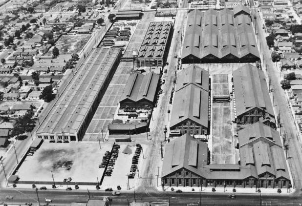
Now about that "Existing Concrete Structure." The property was once home to the Los Angeles Railway's South Park Shops (and, until recently, Metro's Division 14 Bus Yard), a facility where streetcars, and eventually buses were stored, repaired and maintained.
The old Los Angeles Railway South Park Shops. The left half of the property is now the South Los Angeles Wetlands Park, the right is now The School With No Name. The dividing line is 54th Street.
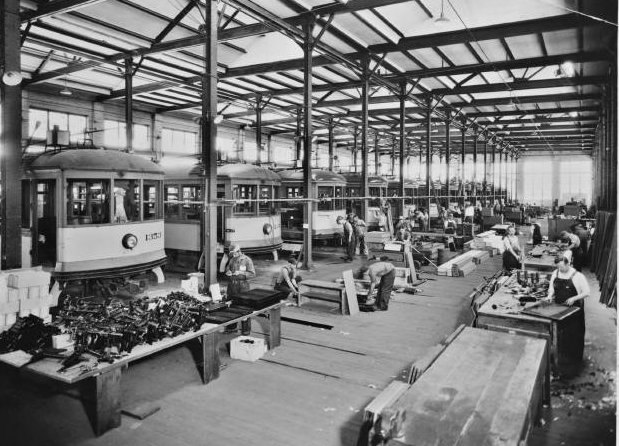
The South Park Shops were in operation from 1906 to 2008, encompassing the various transit entities of the City over those 102 years. The Existing Concrete Structure was a relatively new addition to the facility, built in 1926. It kinda looked like this inside:
Inside the South Park Shops. Safety was highly regarded here, though for some reason the few fatalities that did occur were attributed to workers named "Kenny."
It has no function today, but there are rumors that the Existing Concrete Structure will one day be turned into a streetcar museum. The Militant is feelin' kinda giddy over that. But other remnants of the area's transit past are still evident, for just a block north, on the corner of 53rd and San Pedro, one can see fractures caused by paved-over Yellow Car tracks:
See them cracks? That's track! Cool, huh?
The Militant was glad to finally visit the park, which inspired him to get off his lazy ass and finally do a blog post. Urban design, open public space, environmentally sound (well, mostly...get those bike racks installed, people!), native plant life, and with a historical transit theme...how much more militant can you get? The Militant looks forward to returning a few years from now when the plants are all grown up and the streetcar museum is ready. South Los Angeles, take good care of this place, and enjoy it with pride.

AW HECK WHY NOT (a.k.a An Excuse To Post More Pics):
Looks like a river. Existing Concrete Structure representin'.
A local family enjoys their new park.
A young native California Laurel grows here. Why, they even named a canyon after it.
Did you know Purple Needle Grass is the State Grass of California?
Underneath this gated section is where the storm drain water enters the park and gets filtered.
The new look of South Central.
Poor Jan Perry, she just doesn't get any respect these days...
The infamous School With No Name.
No comment.
These birds find the new Wetlands Park something to crow about.


Sunday, February 12, 2012

Heavy Metro


Here's absolute proof that Metro Rail RAWWWWKS!!! The Eastside-based hardcore band It's Casual performs "The Red Line."

Saturday, December 31, 2011

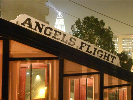
Happy 110th, Angels Flight!

Today is not only the final day of 2011, but 110 years ago today, Col. J.W. Eddy gave us our beloved  Angels Flight funicular railway, which has survived countless ups and downs through the years - literally.

Unfortunately, it wasn't even given a Centennial celebration in 2001 since it suffered a tragic accident in February of that year.

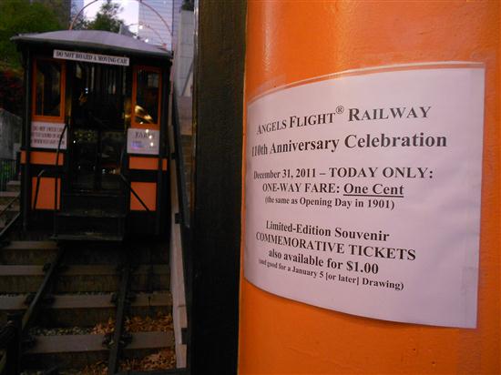
So today, to honor its century-plus-a-decade birthday, the Shortest Railway In The World is offering prices like it was 1901. So instead of a quarter -- You get to ride for a penny!

Interesting, since, when you adjust for inflation, one cent back in 1901 is worth about 27 cents today. But who cares? You get to use up your pennies!

For most of Angels Flight's history, the fare was five cents. According to an article in the Pacific Electric Railway Journal, written in 1958:

"Shortly after the service officially opened on December 31, 1901..."Tickets were cheap and it soon became labeled as 'The 1-cent Line' because of the penny service. It competed with nobody, except for theunlikely pedestrian who tried to save a penny by hiking up the 207 steps along the Third Street tunnel.


Increased operating costs eventually forced Col. Eddy to consider and then finally raise the fare to 5 cents."

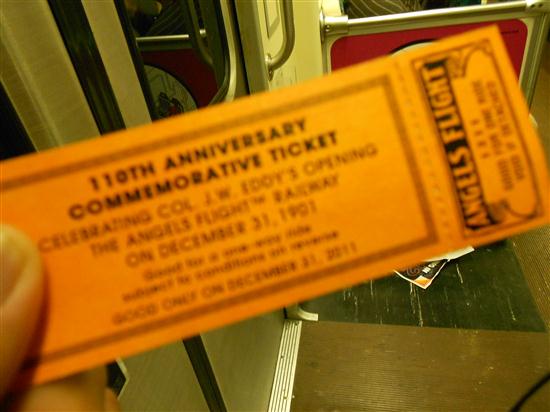
Today, though, the railway will also be selling up to 1,000 commemorative tickets for a dollar. All you collectors in da house!

This year was also a special one for Angels Flight -- in true Hollywood fashion, the funicular played a cameo role in the current movie, The Muppets (A film that happened to be written by a couple of Los Angeles natives and was surprisingly militant in nature at times).

Last year, The Militant earned the dubious distinction of being the last Angels Flight rider of 2010, the year it finally returned to service after the 2001 accident. He may or may not repeat that feat this year!

In any case, the railway is open today until 10 p.m., so bring some pennies and wish Sinai and Olivet a happy 110th!

Pictures of the 110th Anniversary:
A father and son enjoy the flight up.
The annual Angels Flight bulletin.
City Hall with the Lindbergh Beacon FTW!
The Militant got his ticket!

Friday, December 30, 2011

A Balian Points Of Light


For those of you still trying to get your Holiday Spirit on, get on up to Altadena. It's not only home to the famous Christmas Tree Lane on Santa Rosa Avenue, but it's also home of one of the biggest light displays in town.

The famous Balian mansion on Mendocino Lane near Allen Avenue, has been lighting up their house every Christmastime since 1955. The Armenian American family built an empire out of selling ice cream in 1949 and today is the largest supplier of ice cream to the LAUSD and other school districts (those of you who went to LAUSD schools know what's up).

The Militant would have linked to their website in the above paragraph, but...they don't have one.

The Militant checked it out recently and was floored. Yeah, it's bright, but surprisingly not as tacky as you'd think (seriously, there have been some real awful ones around town). It's also an equal-opportunity Christmas display, with religious figures of The Nativity, Three Wise Men and angels on one side, and secular wintery figures of Santa Claus, snowmen and sleighs on the other. Naturally, it's a tourist attraction - The Militant counted about two dozen people, mostly families, posing for pictures or taking videos.

It's relatively easy to get to - just take Allen Avenue north, keep going, keep going, keep going...after you pass New York Drive and the school on the right side, make a right on Mendocino. YOU CAN'T MISS IT, LOL. It's also transit-accesible - take the (M) Gold Line to the Sierra Madre Villa Station, and take Metro Local 264 (why you can't take a single bus from the Allen Station (the 686 stops there, but only takes you to New York Dr.)...that's Metro Logic). You can ride your bike, of course, from the Allen Station.

A Nativity scene with the Three Wise Men...

...and just a couple yards away, another set of Three Wise Men. That's gonna be awkward when they arrive.
Jolly Old St. Nick appears to be setting a brush fire!

Families pose for pictures at Altadena's biggest tourist attraction.

Wednesday, November 16, 2011

SGV Week: The San Gabriel Valley, Defined

Ever since The Militant first announced San Gabriel Valley Week, more than a few of you asked him to define the San Gabriel Valley's boundaries. Defining regional boundaries is not new for The Militant, as he successfully settled the Eastside/Westside geographical dichotomy by defining Los Angeles' center back in 2008, so he figured he'd take on the SGV.

Now, although The Militant doesn't reveal much about himself, here's what he can reveal from his SGV cred: The Militant has unspecified relatives and family friends from the SGV, and has been visiting those unspecified areas of the valley since the mid-1970s. Some of his best operatives have lived and grew up there. All of the cars the Militant has owned have been purchased from unspecified dealerships in the SGV, and his current automobile was bought at an unspecified dealership in Monrovia (he was smart enough to take the Gold Line and the Metro Local bus there, of course). He also may or may not have maintained employment in the 626 at some point in the past or present. So although he's neither born nor bred there, he feels he has earned considerable Essgeevee cred...(Did he reveal too much there?)

So here 'tis:
[Click on map to enlarge!]
Now, Webster's Dictionary dictionary.com defines a "Valley" as "An elongated depression between uplands, hills, or mountains, especially one following the course of a stream."

So lessee...The San Gabriel Valley is an area surrounded by the San Gabriel Mountains to the north, the San Rafael Hills to the west, the Puente and Brea hills to the south and the 57 Freeway to the east. Interesting how the San Gabriel River/605 Freeway nicely slice the valley in half. The 10 Freeway is the valley's equator. Therefore, the geographic center of the SGV is the 10/605 interchange.

Now...here come the little details: The San Gabriel River and Rio Hondo form an opening known as the Whittier Narrows between the Monterey Hills to the west and the Puente Hills to the east, and encompass other cities that don't perfectly fit the valley bowl (and the 626 area code) such as Montebello and Whittier. But they are undoubtedly linked to the rest of the SGV through the Narrows, so they are part of the SGV. South of Whittier are the Gateway Cities or Mid-Cities which buffer Los Angeles and Orange counties. The Militant considers the southern limit of that part of the SGV as more or less Whittier Boulevard.


The other area of question is towards the northeast of the SGV: Cities such as San Dimas, LaVerne, Pomona and Claremont. Are they SGV or Inland Empire?


The Militant considers them...neither. They are not in the SGV since they are in the 909 area code and not the 626. But they aren't really IE, since they are still Los Angeles County. They are in their own region: The Pomona Valley.

So The Militant's short definition of the SGV goes as such: The entire 626 area code region, plus the geographically-connected cities of Montebello and Whittier. Howzat?!

Tuesday, November 15, 2011

SGV Week: Made In The San Gabriel Valley


Hot and sprawling, you wouldn't think anything of any value could come from a place like the San Gabriel Valley, but think again, it's actually given birth to many people and things, some of which you'd never guess originated here.

For instance, the whole concept of college football "bowl" games started on New Year's Day 1902 in Pasadena with the inaugural "Tournament East-West Football Game" -- eventually renamed "The Rose Bowl" 21 years later. And erryone else be bitin' afta dat.

Speaking of bites, being heavily influenced by Route 66, the postwar car culture and associated suburbanism, a number of well-known food chains were born here in the SGV. By far the most famous is Baldwin Park's In-N-Out Burger, established in 1948. Also started that year was a Temple City donut shop owned by Verne Winchell -- Winchell's Donut House. Supermarket entrepreneur Joe Coulombe started the first Trader Joe's market on Arroyo Parkway in Pasadena in 1967, and on the other side of town six years later, Chinese immigrants Andrew Cheng, his wife Peggy and his father Ming Tsai opened Panda Inn on Foothill Blvd, spawning the Panda Express chain.

But perhaps the biggest contribution the SGV gave to the food world was the cheeseburger. Yes, the food that LOLcats everywhere crave was invented in Pasadena by 16-year old cook Lionel Sternberger who worked at his father's now-defunct restaurant The Rite Spot on 1500 W. Colorado in the mid 1920s and "experimentally dropped a slab of American cheese on a sizzling hamburger."

A couple legendary toys were introduced to the world in the SGV -- in the 1950s, the then-San Gabriel-based Wham-O Manufacturing Company gave us the frisbee and the hula hoop (Though both had origins from other times and places, the plastic toy versions we know and love were 100% SGV product).

Even everyone's most beloved little green slab of clay, Gumby, is an SGV native. He was created in the early 1950s by recent USC film school grad Art Clokey and his wife Ruth in their Covina home. GUMBY!!! GUMBY, DAMNIT!!!

Other famous San Gabriel Valley natives inclue World War II General George S. Patton (San Gabriel), former New Mexico governor and presidential candidate Bill Richardson (Pasadena) and cooking legend Julia Child (Pasadena).

The SGV's biggest contribution to music is Pasadena's own Van Halen (none of its members were SGV natives, but the band itself originated here), formed in 1972 as "Mammoth" and renamed to VH two years later. The Black Eyed Peas' singer Fergie (Hacienda Heights), the late scatting '90s Euro-house singer Scatman John (El Monte) and "Toy Soldiers" singer Martika (Whittier) also all hail from the SGV.

Remember this guy? Straight Outta Whittier.
Two major Oscar-winning actors were also born in the San Gabriel Valley: Sally Field (Pasadena) and Tim Robbins (West Covina).

A number of TV child stars also came from the SGV: Punky Brewster's Soleil Moon Frye (Glendora), Family Ties' Tina Yothers (Whittier) and even Steve Urkel himself, Jaleel White (Pasadena).

Being full of recreation areas, the SGV also spawned a number of professional athletes -- most notably former UCLA Bruins and Dallas Cowboys quarterback Troy Aikman (West Covina), former Yankees and A's (and current Rockies) slugger Jason Giambi (West Covina) and Phillies second baseman Chase Utley (Pasadena). but the SGV-born athlete The Militant is most partial to is none other than former Dodger Nomar Garciaparra (Whittier). Oh yeah, he played on some Boston team too.

Yes, great things can and do emerge from that vast flatland surrounded by the San Gabriel Mountains, and the San Rafael, Monterey, Puente, Brea and Pomona hills. SGV, you definitely can has cheezburger.

Monday, November 14, 2011

SGV Week: The Militant Is On A Mission

The Militant wanted to start off San Gabriel Valley Week with a post on the eastern glen's namesake and cradle of civili...er...Western civilization - Mission San Gabriel Arcángel, located in its eponymous city.

It was founded on September 8, 1771 - a full decade before the City of Los Angeles was founded.

But what most people aren't aware of, is that the stately mission, which has withstood centuries of earthquakes, and has flown under the flags of four nations, isn't even the original San Gabriel Mission.

The mission is actually the San Gabriel Mission 2.0.

History is a sticky thing. Though the founding of the 21 missions of  Alta California were credited to one Fr. Junipero Serra, the actual on-site founders of the San Gabriel Mission were padres Padro Cambon and Angel Somera. And it wasn't even planned to be in the San Gabriel Valley -- the original location was along the Rio de los Temblores, now known as the Santa Ana River. Yes folks, the SGV could have been located in the OC...

But they founded the O.G. San Gabriel Mission some 20 miles northwest along another river - the Rio Hondo, which, at least in that location, still flows  in its natural state.

The new transplants moved into the neighborhood next to the native Tongva villages of Shevaangna and Isanthcogna (you do know your Na's by now, right?), where they reaped the benefits of the riparian environment and grew crops. Newly-founded missions didn't yet comprise of a large stone church and neighboring adobe buildings -- they resembled forts with temporary wooden structures.

In 1776, a large flash flood oveflowed the banks of the Rio Hondo and flooded their compound. So the padres packed up and moved five miles to the northwest, a good distance from another river - the San Gabriel River - yet close enough to access it. The mission building that we see today wasn't built until the early 1790s.

The O.G. mission site, known as "Mission Vieja" (no, not Mission Viejo) is long gone, but a little-known monument stands on its site -- on a mini-park on the corner of San Gabriel Boulevard and Lincoln Avenue, right at the edge of Montebello. It's a simple landscaped corner with a familiar El Camino Real bell and a stone marker which reads:
Take note of some of the names, especially "Walter P. Temple." We'll get to that name later in San Gabriel Valley Week!

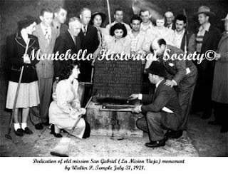
 The marker was dedicated in 1921 to mark the sesquicentennial of the founding of the mission. Pictured right is a photo of the dedication ceremony. The site is also a California Historical Landmark (#158). It's easy to miss, and it's nearly impossible to park there, though there's a dirt clearing  just past the Montebello City Limit sign on Lincoln Avenue that could fit a car. Of course, the Whittier Narrows Recreation Area is full of awesome bike trails, and you can ride all over the place, and visit the nearby Bosque del Rio Hondo park just across San Gabriel Blvd, or ride on the Whittier Narrows Dam about a mile to the south along the Class 1 bike path. Score one for bikes in the SGV!

The San Gabriel Valley, built on history, seems to celebrate it, as well as the vast natural expanse of the Whittier Narrows area. There may or may not be more of this...stay tuned!

Friday, November 11, 2011

On 11/11/11, This Militant Goes To 11

Gotta love being on the front end of the millennium. Some people say we're living in End Times, but in terms of dates, we're living in fun times. Two years, two months and two days ago, The Militant gave a big-up to the 99 Cents Only Stores on 9/9/09. On 10/10/10, The Militant joined tens of thousands at the inaugural CicLAvia.

So today, on 11/11/11, out of the four million people in Los Angeles, The Militant Angeleno was the only one who thought of no more appropriate place to be on that magic second than...1111 11th Street.

Of course, there's a West 11th Street and an East 11th Street, as well as an 11th Street down in San Pedro. Well 'Pedro is a long-ass bike ride, and West 11th Street? Though a major sports venue and entertainment center are located there, the 1100th block actually doesn't exist anymore, thanks to a legendary sports announcer.

So it left one solitary choice - 1111 East 11th Street, just off of Central Avenue. The Militant was in this area not too long ago, for last month's CicLAvia, but this place looked much different on a weekday.

The entire block is occupied by car stereo shops, as well as DJ/lighting stores. The area sounds like a mashup cacophony of rap and reggaeton music pumping out of demo speakers and fresh installs while, cars and trucks back in and out of shop driveways and day laborers hail every car that passes by in hopes of scoring a car stereo installation gig.

The Militant has come across unexpected retail areas of Los Angeles before, such as The Hair District on Wilshire Boulevard, but this is a new one...call it the Car Stereo District, Bass City or BOOMtown.

But on 11:11:11 a.m., on Friday, 11/11/11, The Militant spent the once-in-a-millennium moment here, on front of Sam's Music, on 1111 E. 11th Street:
And one of the store's employees had the most "WTF are you doing?!" look on his face.

So, Angelenos,  now you know where to get your boomin' system...on the 1100th block of East 11th Street. Where every day during business hours, the retailers on that block turn it up...to 11.

Happy 11/11/11, Everyone!